On the Road is a weekday feature spotlighting reader photo submissions.
From the exotic to the familiar, whether you’re traveling or in your own backyard, we would love to see the world through your eyes.
Good Morning All,
Looks like surgery Thursday, so far so good. Thanks to all for thoughts and prayers, he’s a really great guy.
Have a wonderful day, and enjoy the pictures!
Today, pictures from valued commenter ?BillinGlendaleCA.
Commenter Dangerman alerted me to the bloom in the Carrizo Plain, so I made plans to drive the Prius up there. The Carrizo Plain is grassy plain(the largest in California) between the Temblor Range on to the east(with the Central Valley on the other side) and the Caliente Range on the west(with the Coastal Range further west). The San Andreas Fault runs along the foot of the Temblor Range and is a noticeable part of the terrain. Soda Lake, a 3,000-acre alkaline lake is in the center of the plain. The northern third of the plain is privately owned and consists of cattle ranches and solar farms. The southern portion is a National Monument, administered by the Bureau of Land Management. On a clear day, Mt. Pinos(the hike to the summit was feature in last year’s Halloween edition of OTR) is visible towards the south.
Taken on 2019-04-19 00:00:00
Carrizo Plain, CA
While the super bloom wasn’t as super as it was a few weeks prior, it was still a noticeable part of the landscape. You can see the bloom on the far shore of Soda Lake and patches in the grasses on the near shore. This was taken on a hill above the lake that they’ve set up a road and trails to provide an overview of the lake and the plain.
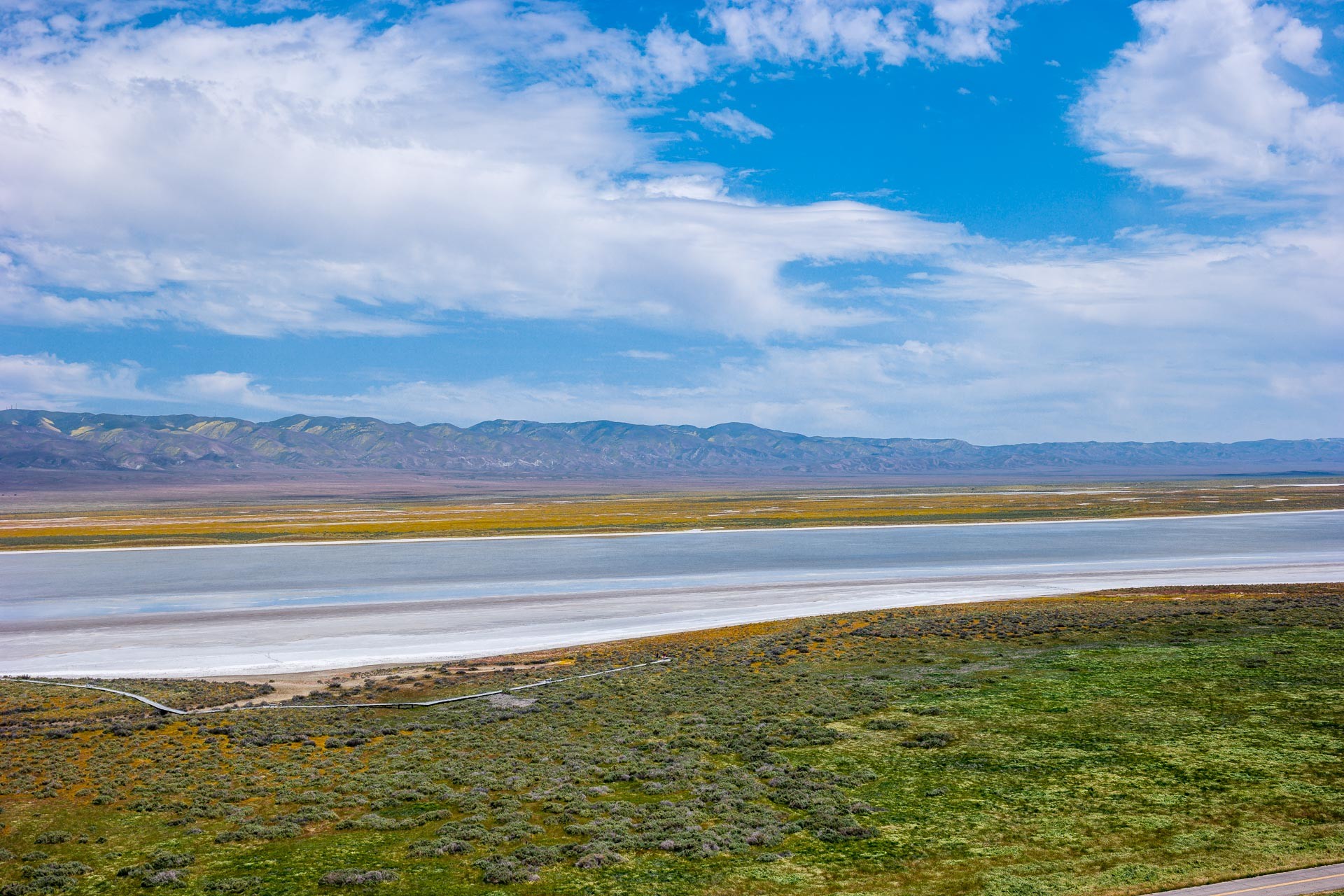
Taken on 2019-04-19 00:00:00
Carrizo Plain, CA
This was also taken from the Observation Hill and looks to the west and the bloom towards the Caliente Range. The purple and gold flowers dominate the plains leading up the the hills.
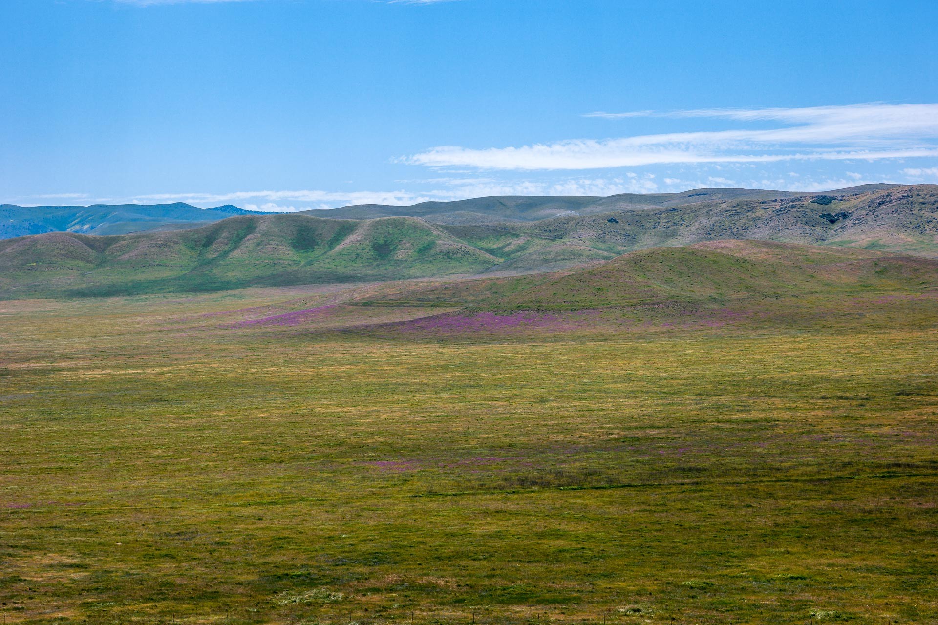
Taken on 2019-04-19 00:00:00
Carrizo Plain, CA
Here, we’re looking to the south across Soda Lake(which is dry in the summer months) towards Mt. Pinos 50 miles in the distance. You can see the bloom on the side of the Observation Hill as well as the distant shore of Soda Lake as well as snow on the upper slopes of Mt. Pinos.
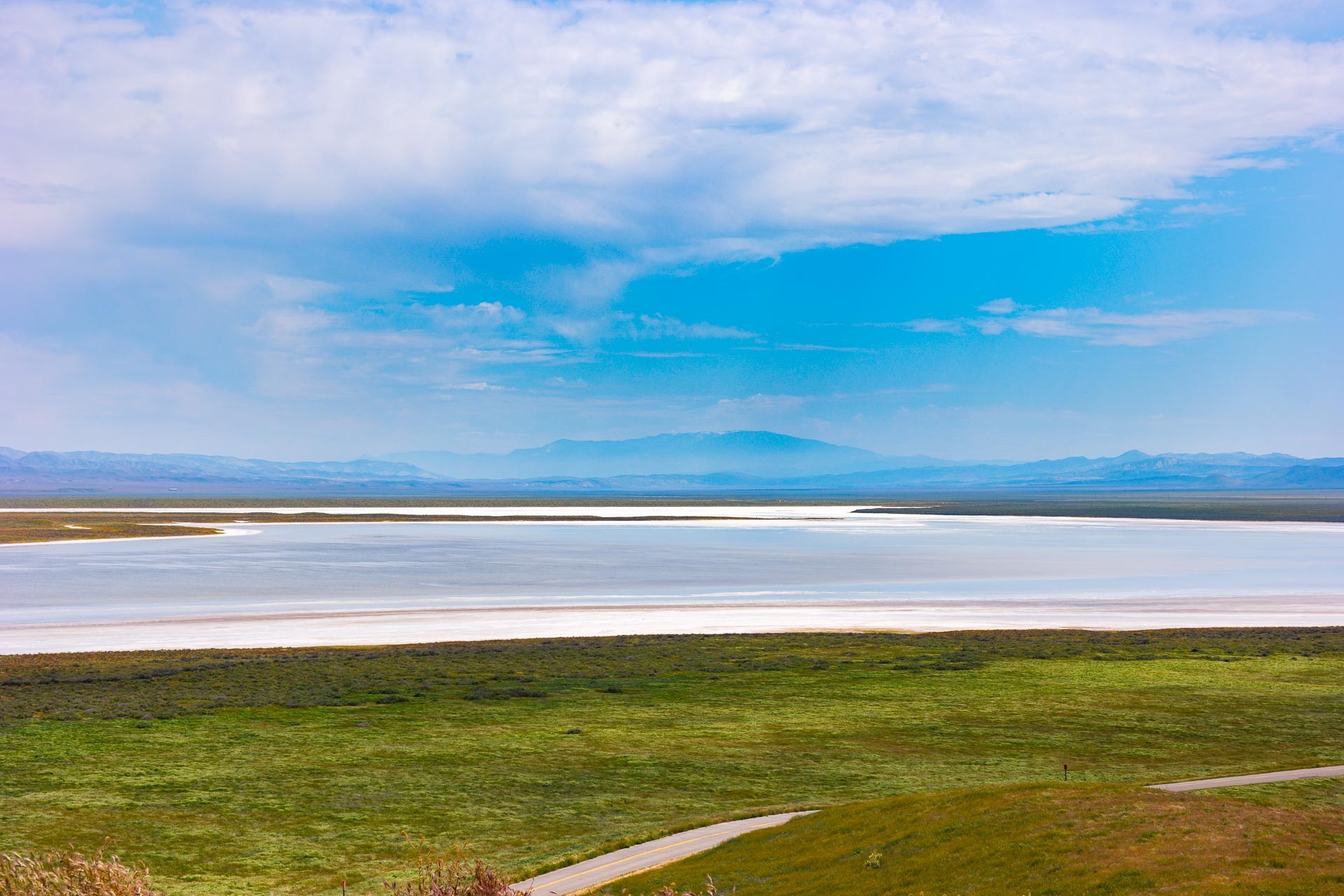
Taken on 2019-04-19 00:00:00
Carrizo Plain, CA
Again we’re looking south, but this time at the shore of Soda Lake. I kept the camera low to the ground to show the immense salt flats in the now drying lake and the really spectacular clouds in the sky. Mt. Pinos is in the lower center of the photo. I didn’t notice the stick in the mud just left on center when I was taking the picture, but I think it really makes the photo much better.

Taken on 2019-04-19 00:00:00
Carrizo Plain, CA
Since clouds are one of the areas where IR really excels, I had to include a IR photo(of course I did). This is looking west from Observation Hill across Soda Lake to the Tembler Range. I was worried about two things when I planned our(Madame accompanied me) trip up to the Carrizo Plain: it was forecast to be 50% cloudy(that turned out to not be a problem) and the drive from the south involved a gravel road(we took the longer route from the north).

Thank you so much ?BillinGlendaleCA, do send us more when you can.
Travel safely everybody, and do share some stories in the comments, even if you’re joining the conversation late. Many folks confide that they go back and read old threads, one reason these are available on the Quick Links menu.
One again, to submit pictures: Use the Form or Send an Email
Amir Khalid
The third and fifth photos aren’t loading for me, but the other three look magnificent.
?BillinGlendaleCA
@Amir Khalid: Here’s the fifth photo, I’ll upload a copy of the third on Flickr.
ETA: And here’s the third.
Amir Khalid
@?BillinGlendaleCA:
Awesome.
?BillinGlendaleCA
@Amir Khalid: Thanks?.
JPL
the pictures are beautiful
?BillinGlendaleCA
@JPL: Thanks.
arrieve
Beautiful as always, Bill. Thanks for the morning pickup! I especially love the first photo.
?BillinGlendaleCA
@arrieve: Thanks, I think that caught what remained of the bloom best.
Skepticat
Will be sending more strong vibes Thursday and after. Please keep us apprised.
Joy in FL
Sending good thoughts and energy.
SoupCatcher
Beautiful as always, BillinGlendaleCA. Looks like you came in from the north. Not sure how far down the valley you went. Soda Creek Road is unpaved through the middle of the National Monument, but there’s no clearance issues on the dirt section, just a bit of washboard here and there. I drove through on the 8th of this month, on the way back from Los Angeles, and took the 166 to the south end, then traversed the valley to the 58 and took that to the 101. Not much traffic at all, but a wide assortment of vehicle types, including some Prii.
Here’s a shot from my crappy camera phone mid-valley with the road.