On the Road is a weekday feature spotlighting reader photo submissions.
From the exotic to the familiar, whether you’re traveling or in your own backyard, we would love to see the world through your eyes.
Good morning all,
Another Tuesday, another day to be thankful for breath and good cheer.
Submitted March 6, in the beforetime.
Hello fellow Juicers,
Consider this part of the “On the daily walks” series. We are lucky enough to live near a handful of trails, so we only had to drive a few minutes to start this hike (but the drive cut out about 900 feet of elevation). This is in the Pacific Palisades area of the Santa Monica Mountains. Oh, regarding my nym (from the not-exactly-a-classic Kentucky Fried Movie), my real name is Mike, but I came up with that nym in a fit of divine, sarcastic inspiration while getting frustrated at having to come up with yet another username.
For the camera geeks, I’m using an Olympus O-MD E-M1, this time with their cheap, but decent, 40-150mm lens on it (it’s a micro four-thirds camera, so double those numbers for the full frame equiv.)
Enjoy and hang in there!
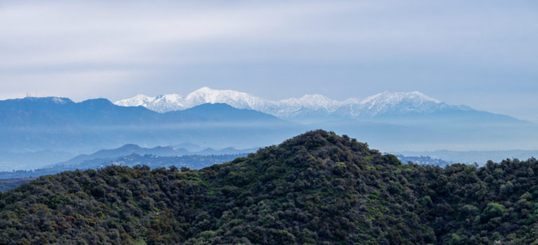
A pano looking towards Mt. Baldy (50+ miles away) – I’m not sure just which one it is from this side :-/ Anyway, it’s got a nice pile of fresh snow :-)
On the left side, you can see part of Mt. Wilson (with all the transmitters on it), and a glimpse of the Hollywood sign, about 1/3 up and 1/3 from the left. The LA basin is on the right and the valley is to the left.
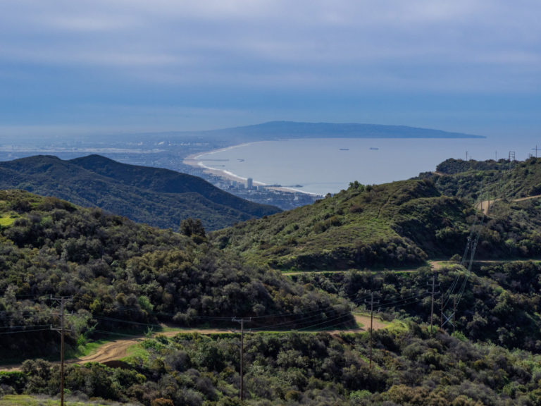
This one is looking towards Santa Monica Bay and Palos Verdes. You can see the expanse of LAX on the left just above the ridge. And you can see the fire road we’ve been walking on. At first we were doing the ridge trails next to it (which you can also see in this picture), but after flicking a couple ticks off my wife’s pants, we decided to stick to the fire road. We also heard tell of a mountain lion in the vicinity about a half mile further than we went (otherwise we would’ve hiked a bit further than we did) and saw a coast guard helicopter circling the area.
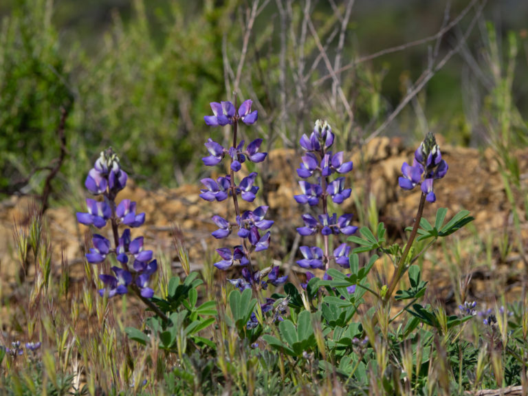
Some lupines.
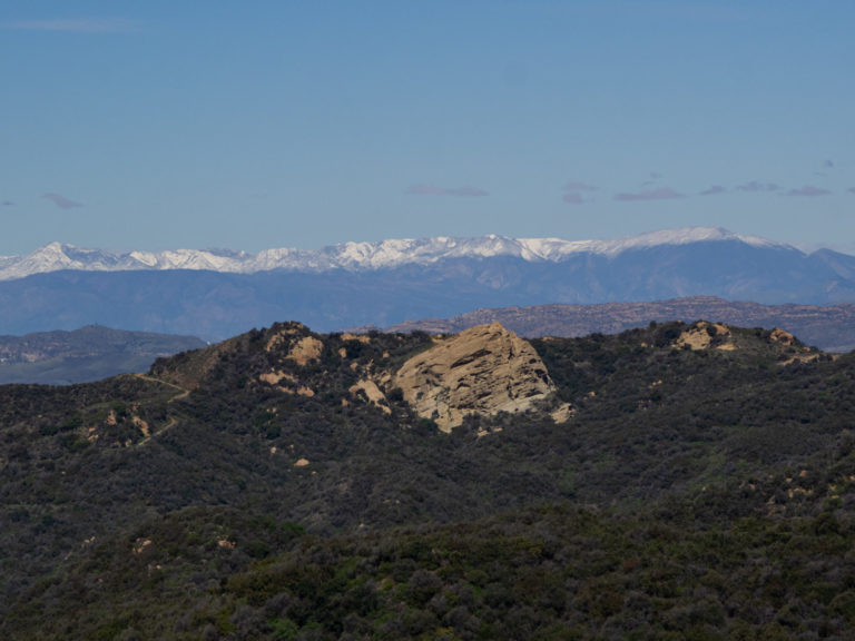
This is a view over Eagle Rock in Topanga State Park (we’re in the park, too), looking towards what I think is the Topatopa Mountains with fresh snow, or at least part of Los Padres National Forest.
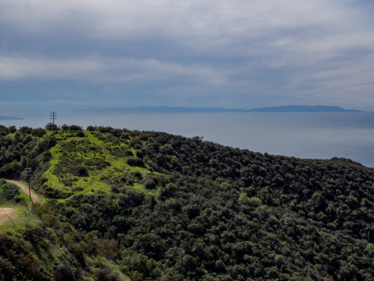
A view of Santa Catalina island (we just call it Catalina). For mac folks, the new default OS desktop picture is of that island, from the right-hand (north-west) side.
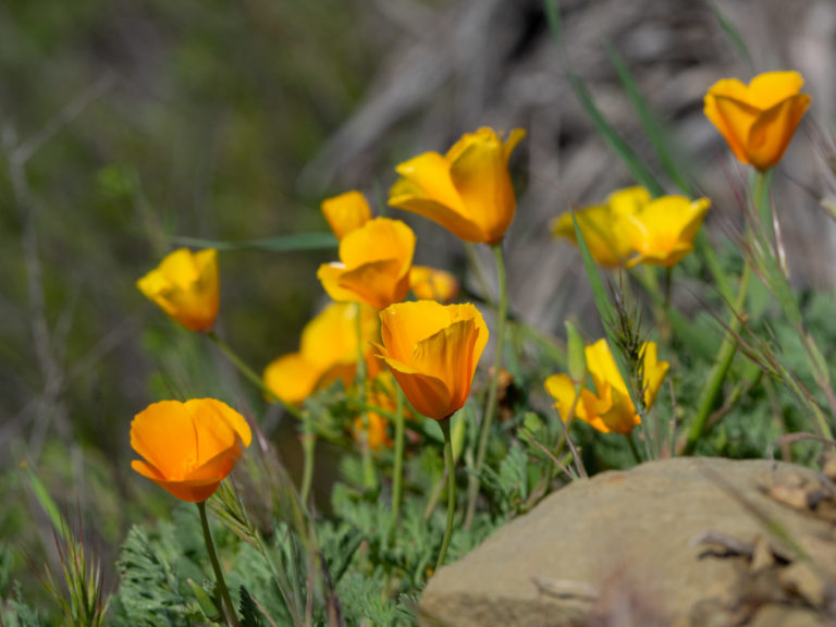
There were just a handful of California Poppies in bloom.
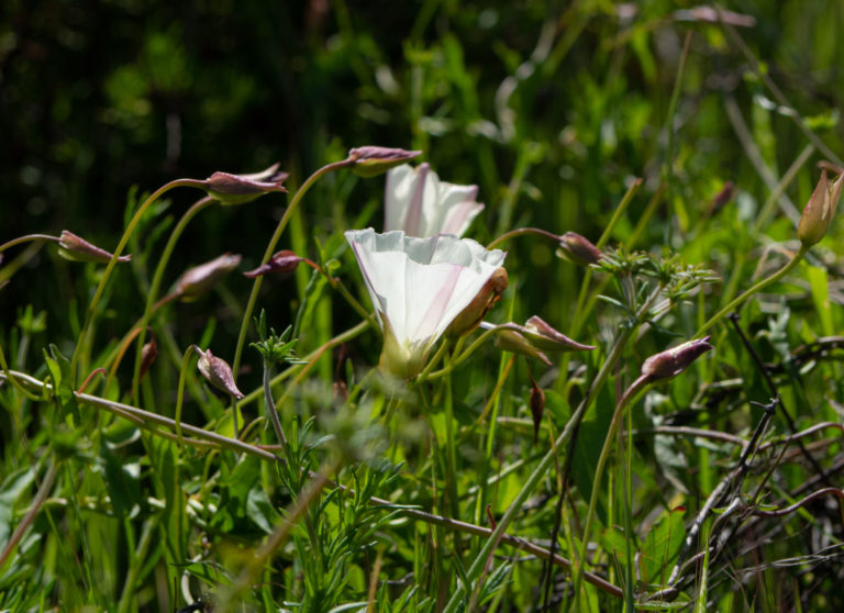
And here’s a Morning Glory.
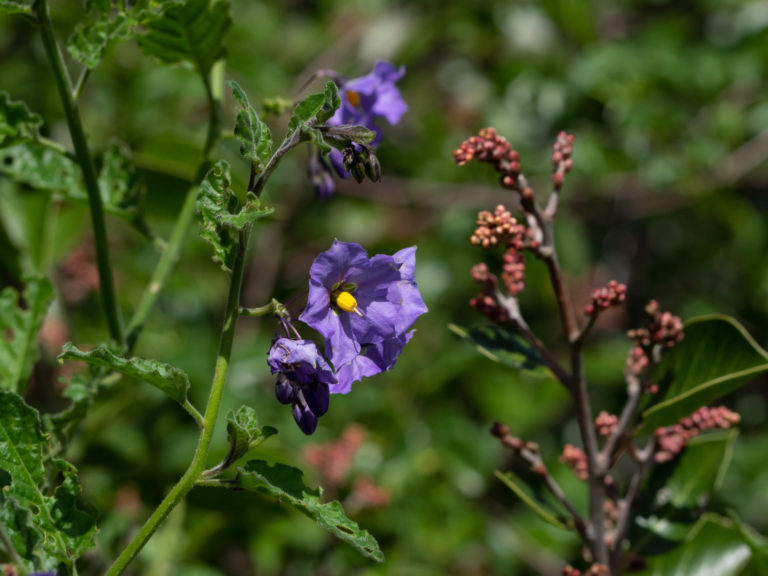
And finally, some purple nightshade.
JPL
Lovely!
p.a.
Thanks!
?BillinGlendaleCA
To answer the question in first picture about which one is Mt. Baldy(aka Mt. San Antonio), it’s the tallest one, a bit to the left of center. Yes, those are the Topatopa mountains with the snow on them, I got some pics of them the same day when I went for a hike to Paradise Falls in TO.
Mary G
Love the wildflowers, sad I won’t see them this year. Thanks for sharing your pictures.
raven
My sis lives within walking distance of LAX. I’ve never seen this angle but I once took a fishing charter that anchored off of those two tankers you can see. They sit to the south of the Manhattan Beach Pier and feed the Chevron refinery at El Segundo.
debbie
Beautiful! I generally don’t have time in the morning to check out On the Road (gotta get to work!), but I’m glad I took a look today. So much green! Such clear air!
?BillinGlendaleCA
@debbie: And they say it’s dry and smogy in LA.
debbie
@?BillinGlendaleCA:
I haven’t been on a plane since the 1990s, but I used to despair at descending into brown smudges in LA, Houston, NYC, etc. Pity they’ll return when this is over. We just do not learn.
arrieve
Beautiful pictures. I was supposed to spend three weeks in the Bay Area in March and I was so looking forward to going home and seeing old friends. I miss the poppies!
Dorothy A. Winsor
Wow. I was scrolling along, trying to catch up on the overnight threads when I skimmed past the first pic and had to stop and go back to look. How beautiful.
Kristine
Lovely photos. Boy, do I need flowers now.
Alain, I received the starter! How large a container do I need? Given the number of additions it looks like it may need to be big.
Betty
Pretty mountains and flowers. Always a treat.
meander
Beautiful photos. I lived in Ventura for a year and the Santa Monica Mountains were my favorite hiking spot. Challenging trails, long drives to some of the more isolated trailheads, but the scenery, flora, and fauna made it all worth it. I don’t recall ever seeing snowy peaks, so thanks for those views.
Mom Says I*m Handsome
@Kristine: I’ve been waiting for the mailman to bring me my yeasty treat too, hopefully today is the day. From what I’ve read about reconstituting our starters, there are multiple cycles of “feed / wait / discard three-quarters / feed again”, with the “discard” part keeping the starter from outgrowing its container.
Wonderful pictures, reminds me of the Marin headlands. California’s coastland is a marvel.
BigJimSlade
Thanks to everyone for the kind words :-)
My wife and I go hiking pretty much every weekend (except now, sad trombone sound), so this is just what I do every time (take a bunch of pictures – I must have a thousand flower pictures).
If you want to see a bigger version of any picture, just right-click and open it in a new window, then remove the numbers before the .jpg in the file name, for instance, here’s the panorama, but in this version you actually can get a glimpse of the Hollywood sign (again, one-third of the way up and one-third of the way from the left):
https://balloon-juice.com/wp-content/uploads/2020/03/P3180052-Pano.jpg
vs
https://balloon-juice.com/wp-content/uploads/2020/03/P3180052-Pano-768×350.jpg
(So after opening the image in a new window, I deleted ‘-768×350’ – give it a shot!)
Even when we go on vacations, all we really do is plan hikes ;-)
BigJimSlade
@?BillinGlendaleCA: Thanks for the info (and all the pictures you’ve shared with us for a long time)!
BigJimSlade
@meander: My favorite area for the Santa Monicas is right by Oxnard – the Mugu Peak area with the Chumash trail (right across from the Pt Mugu Naval Air Station’s firing range) and the Ray Miller trail. Expansive hills, fantastic ocean views, and, in spring, plenty of flowers. Unfortunately we might be miss much of the bloom this year :-/
Mike S
Greetings from SM. We sure do live in amazing place.
BigJimSlade
I haven’t posted much on flickr, but if you want to see some more (a couple dozen) pictures:
https://www.flickr.com/photos/149867803@N04/
and I just started an instagram account, though I’m not too committed to it (just 17 pictures so far):
https://www.instagram.com/ig_mikeonahike/
Ruckus
@debbie:
Actually the smog is absolutely nothing like it used to be. On a very bad day 40-50 yrs ago you wouldn’t have even known those mountains existed or that there was an island off the coast. We gauged how bad it was by how far we could see from the shop in the middle of LA proper. The tall buildings downtown were about 3 miles away. If we couldn’t see them, that was a bad day. Mount Wilson was about 25 miles away and we’d be lucky to see that maybe twice a year. Now it’s actually rare to even be able to see the smog and there are well over twice the population and cars. For an old native the difference is stunning. Yes, smog still exists and the inversion layer can still hold it in, but absolutely nothing like it did.
BigJimSlade
@Ruckus: Yep, and there are something like a million more cars on the road now, too! I remember driving to high school a little bit short of downtown LA in 1983-85 – looking over Hollywood from the Santa Monica freeway the air was often pretty damned brown. I’ve read that everyone (in the 40s?) used to have backyard incinerators to burn all their trash and the air was really bad then.
BigJimSlade
@Mike S: Greetings! Santa Monica has been sort of a 2nd backyard for much of my life!
JustRuss
Thanks for the pics. Grew up in Ventura, did lots of great hikes in those mountains.