On the Road is a weekday feature spotlighting reader photo submissions.
From the exotic to the familiar, whether you’re traveling or in your own backyard, we would love to see the world through your eyes.
Today is the start of week two of On the Road After Dark as we catch up on submissions.
On the Road: Week of July 13 (5 am)
Albatrossity – Coso Canyon
way2blue – Hanger 7, Salzburg, Austria
?BillinGlendaleCA – Brown Mountain Dam
Steve from Mendocino – Los Angeles train yard
ema – Pandemic Pics Part Deux: The ReopeningOn the Road After Dark: Week of July 13 (10pm)
Albatrossity – Hovenweep and Chimney Rock
lashonharangue – Yosemite Backcountry
?BillinGlendaleCA – Inyo County
Steve from Mendocino – Los Angeles Harbor
BigJimSlade – Hiking in the Italian Dolomites
Albatrossity
The western US has many well-known and iconic places to visit, e.g. the Grand Canyon, Yosemite and Yellowstone National Parks, and many scenic mountain ranges and lakes. There are also many less well-known but equally fascinating spots, and I have had the privilege of seeing and photographing some of those as well. In these times of lock-down, when future travel plans are among the “unknown unknowns”, I’ve been wandering through old photos and revisiting some of those. I will probably be able to do that for quite some time; I would like to be able to travel again, but for now, these virtual visits are what I’ve got. Here’s one of those places.
Coso Canyon, aka Little Petroglyph Canyon, aka Renegade Canyon, lies in the eastern Sierra Nevada in Inyo County CA. The closest town is Ridgecrest, which I suspect many jackals have also never heard of. This canyon is within the boundaries of the China Lake Naval Air Weapons Station, and that makes access somewhat problematic. But the military brass have an agreement with a museum in Ridgecrest that allowed tour groups to visit the site on a regular basis in the spring and in the fall. Those tours are canceled right now, but if you have plans to visit eastern Kern County sometime in the future, check with them and get on a tour if possible.
Why would you do that? Because this canyon is home to one of the oldest and finest galleries of rock art in the entire country. By virtue of its remote location on a military base, it has not been damaged by yahoos with ATVs and high-powered rifles, like much of the rock art in the rest of the country. And it is ancient, dating back to the Pleistocene, when this region was glaciated, game was abundant, and the dry lakes actually were full of water. The times were not recorded in writing, and the people did not build permanent structures or pass down an oral history, so the petroglyphs of the canyon provide some of the few insights we have into the early history of the peopling of North America.
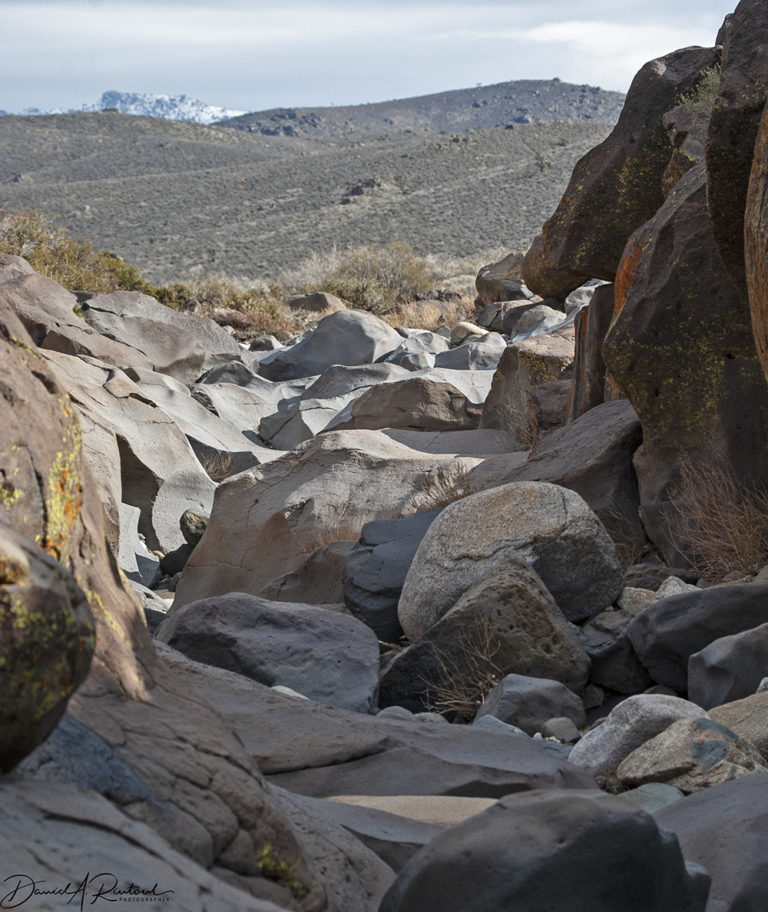
The ride from the entrance to the station to the trailhead at Coso Canyon, climbing up through Joshua Trees and other Mojave Desert flora and fauna, takes about an hour. Pictures are not allowed during that time since you are, after all, on a top-secret military weapons testing range, but we saw some wildlife and even a couple of herds of wild horses. Once at the trailhead you hike a short distance to the canyon and this view.
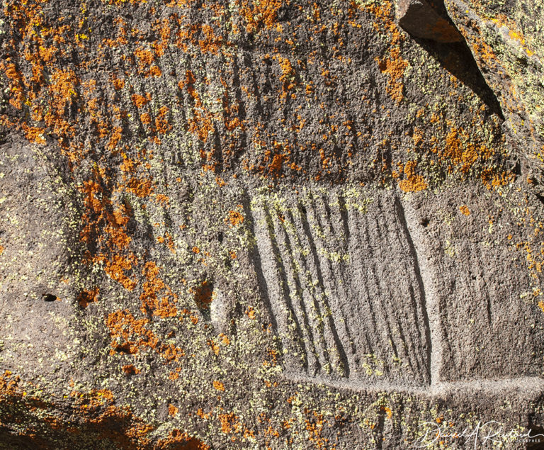
The petroglyphs here at the top of the canyon are the oldest at the site. They have been dated, using various techniques, to somewhere between 16,000 and 10,000 years BP (before present). Most are simple and deeply incised into the basalt rocks here.
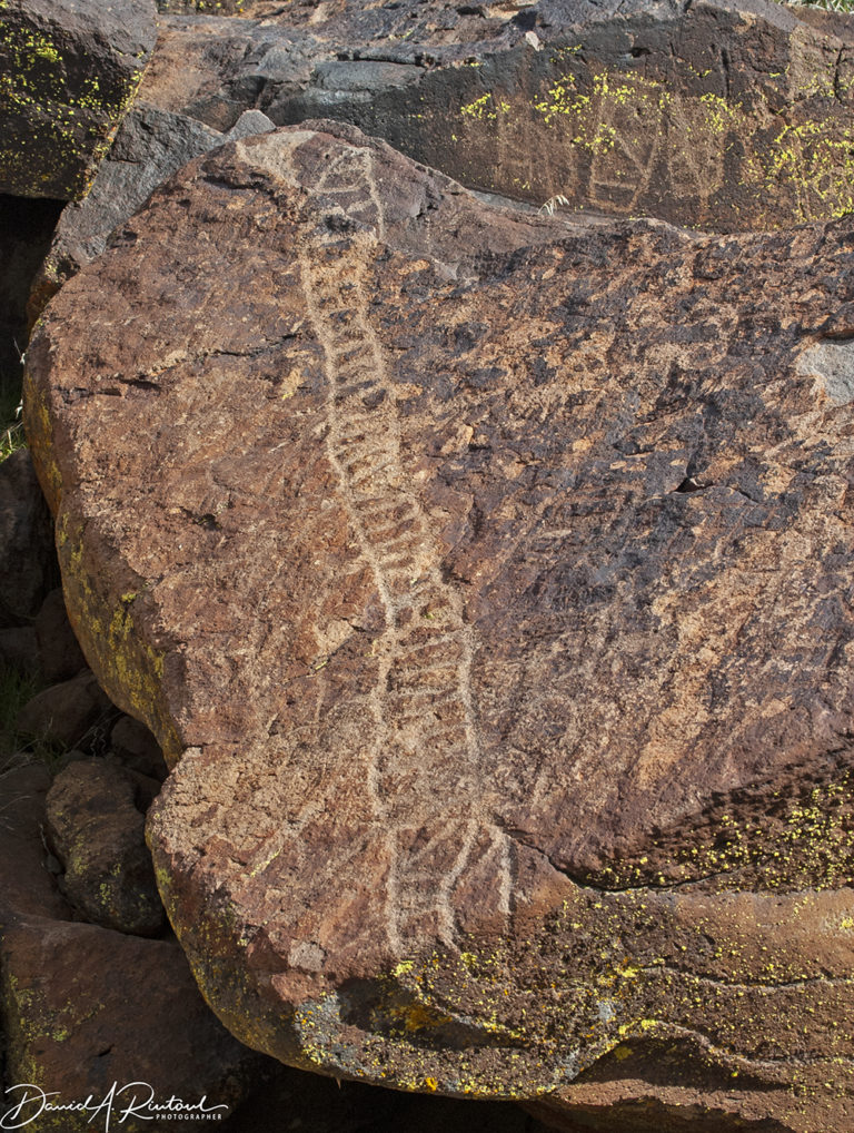
Many of the petroglyphs at the top of the canyon are dominated by simpler designs, such as this one. Is it a ladder? A snake? Something else entirely?
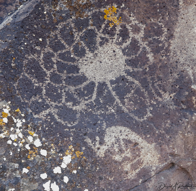
As you head down the canyon you can find some of these simpler designs and the first appearance of human-like figures. Perhaps this is an earlier coronavirus rendition, rendering the human figure helpless. But probably not.
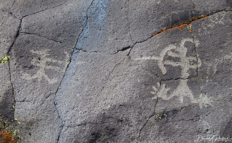
This petroglyph is clearly a pair of humans shooting at each other with bows and arrows. This has to be a relatively recent carving; for much of the history of this site the only weapons were atlatls. The bow and arrow first appeared in this region about 1,500 BP.
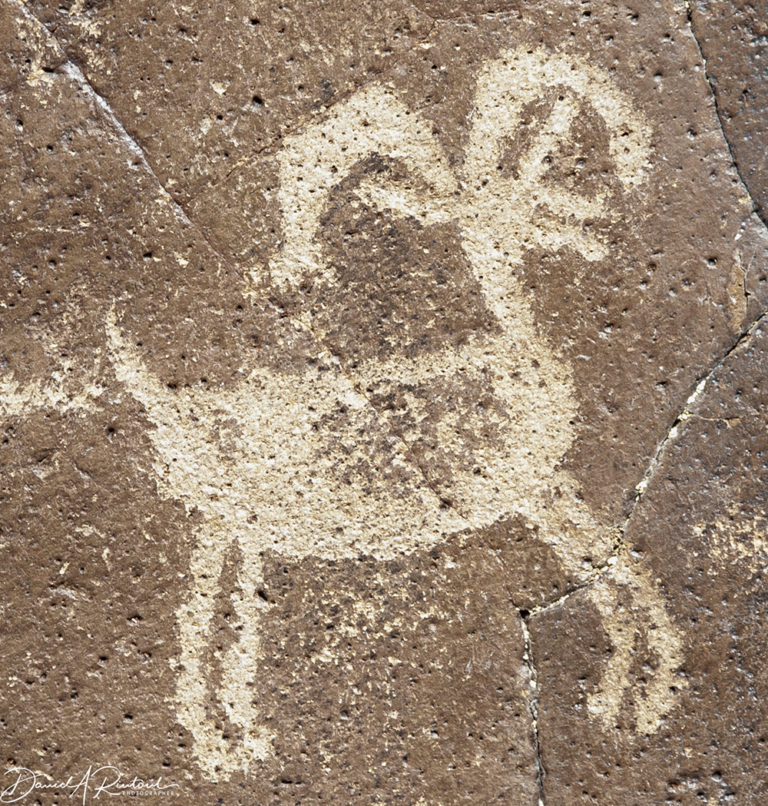
The atlatls were used to bring in lots of game, but the most common depiction of recognizable animals in the canyon would have to be bighorn sheep, like this one.
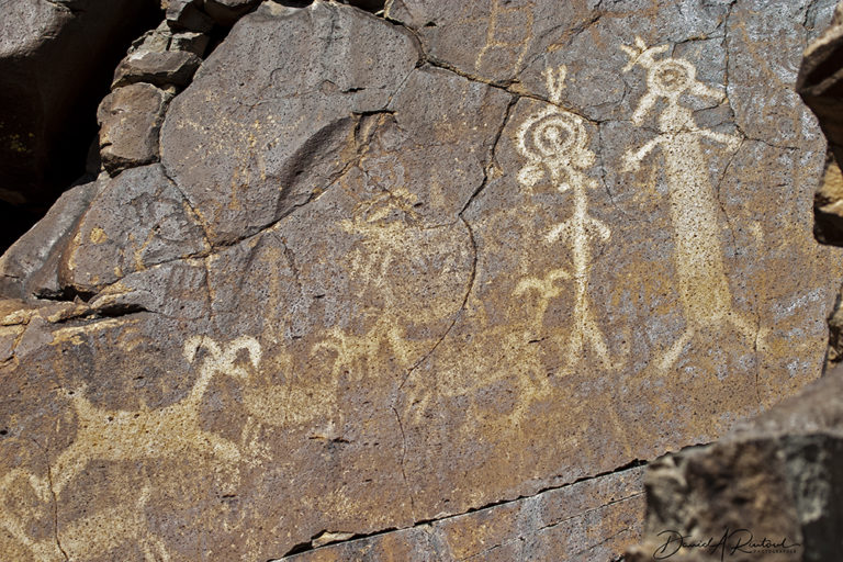
The lower end of the canyon has not just bighorn sheep, but also curious anthropomorphic figures like those at the right part of this panel. There are numerous hypotheses about what these might represent, but again, as with most of these carvings, we will never know what they really mean. And there could indeed be multiple meanings and explanations.
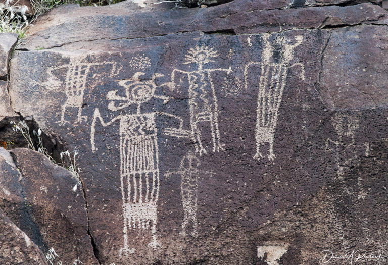
This is one of the most famous panels in the entire canyon. These anthropomorphic figures have been reproduced on t-shirts, postcards, and even beer mugs. My t-shirt has long since disintegrated, might have a few of the beer mugs in my collection!

SiubhanDuinne
Fascinating and beautiful! Wow, thank you, Albatrossity — these pictures are a great way to start the week.
And many thanks to you, too, WG, for taking over On the Road and expanding its scope and reach. I rarely comment in OTR threads, but they’re among my favourite parts of each day.
donatellonerd
@SiubhanDuinne: me too.
JPL
Fascinating.
MazeDancer
What great pics!
Buckeye
Nice. My sister lives in Ridgecrest, so if I ever get out to visit her I’ll add that to the list of things to do.
soup time
I’ve been to Coso Canyon and seen many of those petroglyphs. Thank you Albatrossity for the pics! I lived in China Lake during my childhood. Both my parents worked on the base and almost every year someone would organize an outing to drive somewhere out on the test range to see interesting canyons, geology, and rock art. Of course the organizer had to get permission and someone from the range patrol would be the guide and minder. This was in the 50’s and 60’s.
I remember on one of those trips we had stopped and everyone was out walking around looking at the rock art when someone spotted something. It was a bent up sidewinder missile that had crashed into the rocks about 100 feet up the canyon wall. Our guide herded us all back in the vehicles and radioed the location in to the range patrol so they could deal with it. Sidewinder missiles (and many other missiles and rockets) were developed and tested at China Lake. There are probably hundreds of missiles scattered all over that area.
We often saw small bands of wild burros out in the desert. Their muzzles were festooned with cactus quills. There is extremely little to eat out there, the average annual rainfall was about 1.5 inches. About the only other flora in the area were jackrabbits, reptiles, and a few bird species.
I’ve heard that China Lake Navy base was opened in the early 1940s as part of the Manhattan Project. When I lived there, there was no prohibition on supersonic flights at that time and sonic booms were common, some from quite low level aircraft so they were LOUD.
arrieve
I’ve always loved starting my day with On the Road because I got to see parts of the world I hadn’t visited. Now that I don’t know when, or if, I can see anything apart from my apartment again, it’s even more of a blessing. Thank you, Water Girl, for taking it on.
I’m going through old photos as well — I knew I took a lot of pictures wherever I went, but am a little embarrassed by how many I never bothered to process.
debbie
Are the petroglyphs being protected from the testing?
Albatrossity
@debbie: That part of the base is off limits for weapons testing, yes. It is a huge base.
debbie
@Albatrossity:
Thanks!
stinger
Between the great photography and the informative text, reading On The Road five (or ten) times a week is like having a subscription to National Geographic. Most of the places featured are places I’d love to go but, pandemic or no pandemic, probably never will. OTR is almost as good as being there in person.
Thank you, Albatrossity! And thank you, WaterGirl!
J R in WV
Excellent stuff, as usual !! Petroglyphs are so strange, and we will never, can never know what the various artists were thinking when they carved/painted the ancient images.
Wife and I toured a dozen caves in Spain and France with one of the foremost experts on prehistoric art, and when you pinned him down, he would always admit all the discussion of the works was speculation and guesswork.
We can date them, tell what was used to make them, but the purpose? Why deep underground in caves? Not today’s examples, were in broad daylight, but caves everywhere have paintings and carvings, some in difficult to reach areas, with no modern light sources.
Robespierre was here, 1605
;-)
?BillinGlendaleCA
Coso…sounds familiar. I was at Fossil Falls in the western edge of the Coso Range on Saturday morning. I didn’t know about the petroglyphs. Just a bit of a correction, while Ridgecrest is in Kern county, it looks like the petroglyphs are in Inyo County and in the Coso Range which is east of the Sierra and south of the Inyo Range.
Nice shots.
Miki
Wow – fascinating. I’m always amazed by how the human impulse to create is so enduring.
Joining the chorus of thanks for OTR, early and late.
eclare
So interesting, thank you.
Albatrossity
@?BillinGlendaleCA: Thanks, Bill. Indeed the site is in Inyo County. I didn’t realize that Ridgecrest is basically in the far NE corner of Kern. Of course, my knowledge of California county maps is pretty sparse!
I appreciate the information.
way2blue
Wonderful images. Thanks. This remote corner of California has had my attention since last July’s M7.1 Ridgecrest earthquake. Would love to see the petroglyphs in person.
Tommy D
The Eastern Sierra is a terrific place, tho pretty warm this time of year. Don’t forget Lone Pine which has a museum featuring the hundreds of movies made in the Alabama Hills. Mono County has small mountains made almost entirely of volcanic glass. Mono Lake is its own wonder. Just north of the lake is Bodie, a silver-mining ghost town state park.
?BillinGlendaleCA
@Albatrossity: Being that I was just up there, it was something I noticed.
@way2blue: There was also a pretty good sized quake at Coso last month, though not as big as the Ridgecrest quake last year.
@Tommy D: After shooting at Coso in the dark last Saturday morning, I headed up to the Alabama Hills for sunrise and then up to Whitney Portal.
LongHairedWeirdo
Re: is it a snake, or a ladder, my first thought was it might be the old-time equivalent of “slippery when wet” – assuming there might be some reason to have to walk along that path. It also suggests that certain childhood board games have been around for a *long* time :-).
You see, in the UK, it’s called “snakes and ladders” but in the US, it’s “chutes and ladders” – the “chutes” being slides…
(er, like “sliding boards”. Damn. I haven’t thought of slides/sliding boards for so frickin’ long, the terms look odd, which is why I’m feeling the urge to disambiguate. Worse, I’m remembering al old comic strip of a large horrifying crash (dust cloud, stars, etc.), next panel, a young boy thinking “dog gone it! They should have a SIGN or something!” and last panel is him imagining the proper sign: “No bikes on this dumb ol’ sliding board!”)
Where was I? Right.
And then a quick web search places it at India in the second century BC, which really makes me wonder if it could have still older origins… not that I really think the pattern has anything to do with any sort of game, but it did make for an interesting coincidence.
Tehanu
@Tommy D: We have a lovely painting by Don Suggs called “June Mountain Weather Trap”, evidently painted above June Lake which is near Mammoth. I always think that area is nicer in the summer than it is when crowded with skiers.