On the Road is a weekday feature spotlighting reader photo submissions.
From the exotic to the familiar, whether you’re traveling or in your own backyard, we would love to see the world through your eyes.
Tonight we have llamas, lovely stories and beautiful photos. This should be fun! ~WaterGirl
Yosemite National Park covers over 1100 square miles. In a normal year over 4 million people visit, but the vast majority see only a few square miles – the valley floor, the south rim out to Glacier Point, and along Tioga road through Tuolumne Meadows. Less than 60,000 thousand people get permits to overnight hike in its wilderness, and many of those are weekenders.
For those who have more time, there is a 50 mile loop that goes through spectacular scenery called Matterhorn Canyon. Most hikers doing that loop actually start at a trailhead east of Yosemite near Bridgeport, entering through the Hoover Wilderness, and then crossing the Yosemite Park boundary after a day’s hike. We had tried that a few years before this trip but had to abandon the attempt (long story).
This return visit to the loop was part of a larger 16 day trip throughout the northeastern portion of Yosemite. We were three people with 5 llamas (2 rented) and carried enough provisions to do the entire trip without resupply. Our start was from another trailhead a little further south of the one most people use to do the loop.
On the second day out we were caught in a big rainstorm. Summer storms in the Sierra Nevadas usually start in the afternoon and are over after an hour or two. We tried to wait out the storm, but it showed no signs of letting up. We pressed ahead through the rain and very wet trail for a few hours, hoping to get to our next planned camping location.
Part of staying safe in the wilderness is knowing when to reevaluate your plans. Cold, wet, and with little daylight left, we then decided to set up camp wherever we could. We saw a meadow off the trail to our left and went to explore. It turned out most of the meadow was filled with water – above our knees in places! After a frustrating search we found a spot at the edge of the meadow that didn’t have standing water. Still raining, we set up our rain tarp, unloaded all the gear underneath, changed out of our wet clothes, and started to cook something hot to eat. In the middle of the night, after the rain had stopped, one of the rented llamas developed symptoms suggesting it had eaten a poisonous plant. I helped our friend force an activated charcoal solution down the throat of the uncooperative llama.
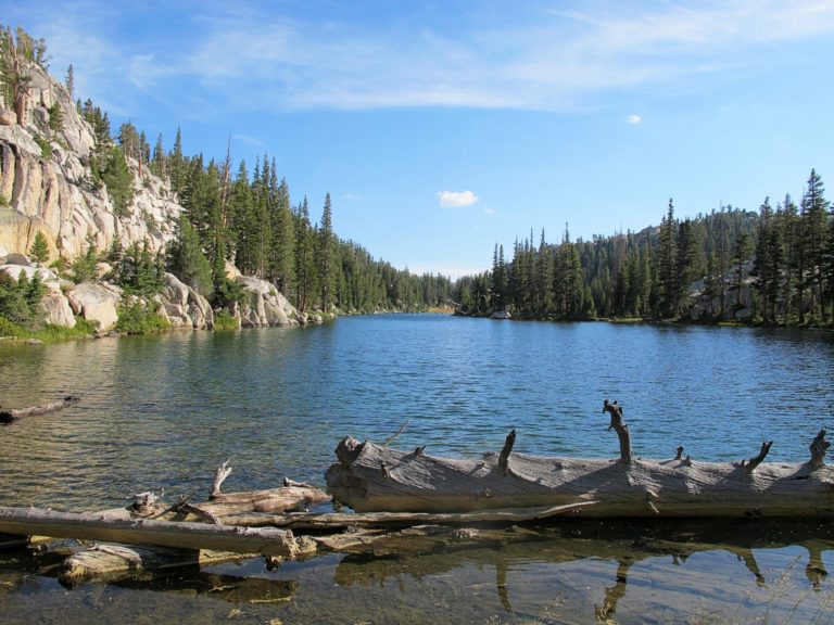
The next morning the skies had cleared. All the llamas were fine. The meadow had drained. We decided to stay another day to let our clothes and gear dry out. We discovered a peaceful unnamed lake that was through the trees on the far side of the meadow. Had we made it to our planned camping location (about a mile further) we would never have seen it from the trail even in clear weather. We all hoped it was a sign that the rest of the trip would not be so difficult.
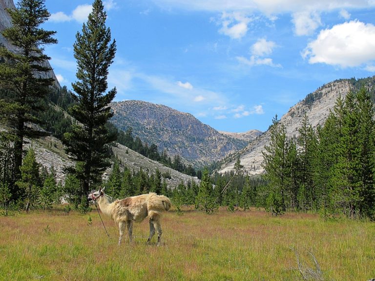
This picture was taken at our next campsite at the beginning of Matterhorn Canyon. Pack llamas have very thick coats and get a haircut in the spring. Unlike show llamas, the haircut is purely functional. The neck and torso are trimmed to avoid heat stress while packing in the summer. The animals don’t like it so it is done as quickly as possible with electric shears, not bothering with the front and hind quarters. This one didn’t get a particularly attractive haircut, but it did the job.
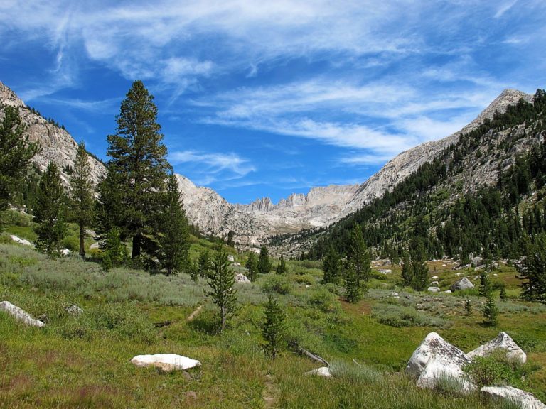
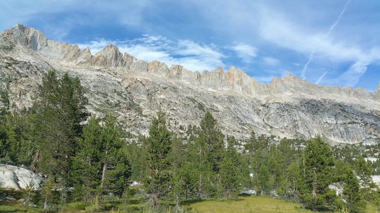
The next day we continued hiking through the canyon. As you walk gradually upward you can see Sawtooth Ridge in the distance beyond where the vegetation thins out. You then reach a tougher switch back section up a rocky trail to Burro Pass.
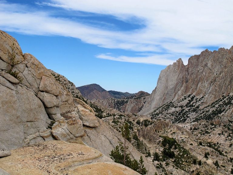
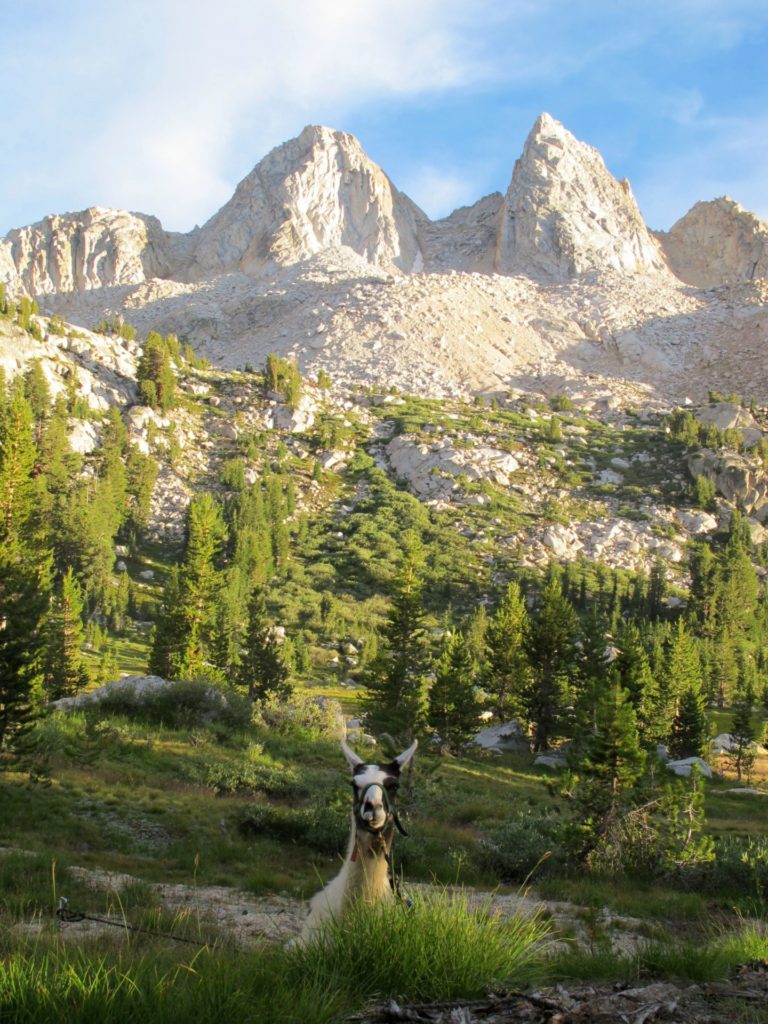
This is at the top of Burro Pass (elevation 11,100 feet). We then descended to where we found a place to camp below Sawtooth Ridge.
This picture was taken from our great campsite below the ridge and away from the trail. A mix of forest, grass, and shrub that was perfect for us and the llamas.
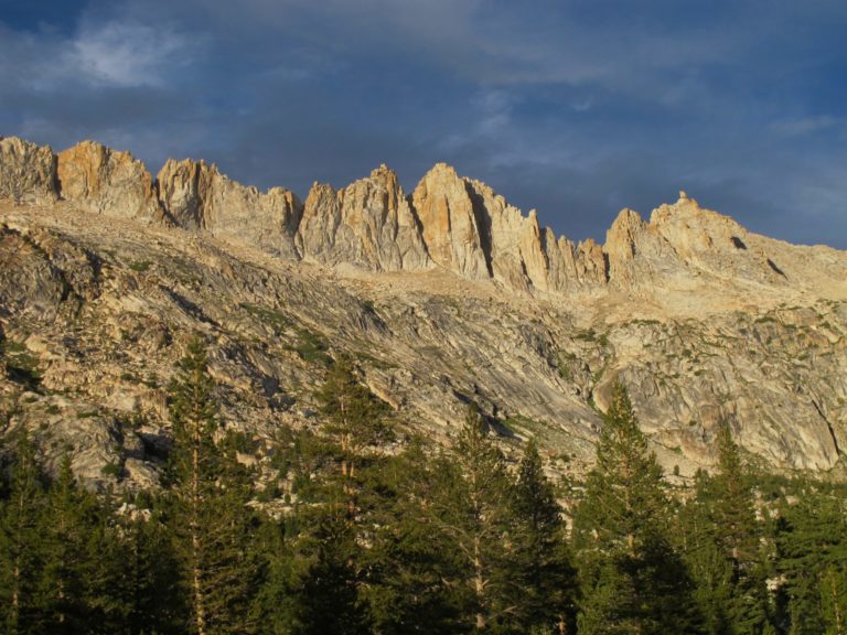
John Muir called the Sierra Nevada mountains the “Range of Light.” Sunrise and sunset really demonstrate that.
Llamas are ruminants. After they browse they often settle down to digest their food. This photo is showing the ridge opposite Sawtooth as the sun was going down.
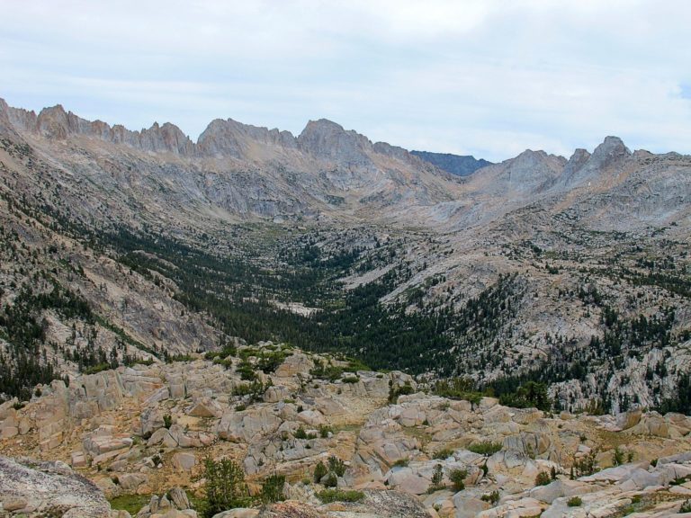
The next day we hiked up and out of the canyon. This photo was taken looking back toward where we had camped – the trees in the center-left. Burro Pass is in the distance in the upper right. The payoff from getting here was worth the difficult start to the trip. If you are ever driving on Highway 395 near Bridgeport look to the west. You can see the tops of Sawtooth Ridge (opposite side as seen from here). Not as good as being there, but a lot less effort – even with llamas to carry your stuff.
MazeDancer
Gorgeous mountain shots.
Also, darn cute llamas.
MagdaInBlack
This is just wonderful! Thank You
Comrade Colette Collaboratrice
Wow! Great pix and story.
Do you need to bring food for the llamas, or can they forage enough?
ETA: I love your nym. One of our rabbis hosts a temple women’s group wine party every year with a brief talk about lashon hara, followed by many, many more or less successful attempts to avoid it as tongues are loosened by the wine and company.
?BillinGlendaleCA
Sawtooth ridge reminds me of Mt. Whitney.
kindness
Nice. Thanks. Needs more llamas. What? Isn’t this a critter blog?
Barbara
Those are great pictures, but forcing activated charcoal solution down the throat of an uncooperative lama had to have been the most memorable part of the trip.
J R in WV
Those high Alpine passes and ridges are awesome.
Thanks for sharing. The highest I ever was was around 13,000 on Mt Antero in Coorado. We were on a great rock-hounding trip. I found a little pit of smoky quartz on the edge of a boulder, and cut it off. Still have it somewhere in all the other rocks.
Beautiful scenery, great photos.
Thanks so much~!!~
Albatrossity
Wonderful images of a spectacular part of the country! Thanks for sharing these.
eclare
Great photos and story!
lashonharangue
@Comrade Colette Collaboratrice:
We take along a little feed in case there is nothing to eat, basically bare rock. Llamas will eat almost anything including dry pine needles. They love fresh grass but will usually find something. We move them around to minimize the impact.
lashonharangue
@kindness:
I have more llama pictures. On this same trip we met up with folks who had pack goats. It was interesting to see the interaction between the goats and the llamas. They seemed very curious about each other.
Amir Khalid
When I was but a naive lad, I honestly thought Yosemite rhymed with Vegemite.
lashonharangue
@J R in WV:
I got up to 13,200 on Forrester Pass on a trip near Mt. Whitney. Couldn’t take llamas up to Whitney – not allowed.
MisterForkbeard
@Amir Khalid: It doesn’t? :)
Meyerman
Beautiful pictures of an inspiring place. When I was young, I hiked Tuolumne Meadows to Sonora Pass, passing through Matterhorn Canyon and then meandering back and forth along the northern edge of the park. I remember around Day 8 passing a group that had packed in. Looked like two mules for each person – one to ride and one for gear. I looked at their comfortable tents and big dinner spread with some envy, but in those days I was happy to travel light.
Mary G
@Barbara: That was my thought! Aren’t llamas major spitters? Did you get covered in charcoal in the pouring rain. But seriously beautiful pictures.
trollhattan
Love the Yosemite backcountry. Love.
lashonharangue
@Mary G:
Llamas spit at each other to establish dominance or to express annoyance at another’s behavior. I don’t lead llamas so much as do group facilitation. Sometimes we had to switch who was connected to who in a pack string to minimize problems.
The sick llama was down on the ground so spitting wasn’t an issue. Wasn’t raining by then but washing the charcoal off was not easy.
Kelly
In 1997 while backpacking the John Muir trail I met an absolutely charming group of ladies in their 70’s each with a pack llama. I can’t recall which pass we were at but we were over 11,000 feet. They had been hiking the Sierra Nevada together since they were teenagers. They had all bought llamas several years before as age was slowing them down. They found a farmer that would board the llamas and haul them to and from the trail heads for them.
BigJimSlade
@lashonharangue did you start from Twin Lakes? i’ve started from there a couple of times going by Barney and Peeler Lakes (there was a beaver plying its trade at the outlet of Barney). On the bigger trip a friend and I made it to Emigrant Lake. Fantastic area.
lashonharangue
@Kelly:
Yes that was the reason we got our llamas.
lashonharangue
@BigJimSlade:
No we actually started south of Twin Lakes at the Green Creek trail head. We had done a previous trip out of Twin Lakes. That climb up to Barney was hot and not very fun.
Did you see my previous OTR about Emigrant Wilderness?
dmbeaster
Love that Yosemite back country. Backpacking to Young Lakes in August with family, which is near this loop.
Hiked from Tuolumne Meadows to Sonora Pass highway, exiting the park at Dorothy Lake Pass, which is just west of your area in northern Yosemite. Went down the Grand Canyon of the Tuolumne, then up to Tilden Lake and Falls Creek in the park. Exited at Leavitt Meadows. 70 or so miles — no longer remember the distance.
You can feel that this part of the Sierra was home to a big ice sheet during the various ice ages — scoured, rounded, and sparse soils even at lower elevations.
frosty
Beautiful! I can’t imagine hiking at 11,000 feet. When I was in La Paz we stayed in a second floor apartment at the lower end of town (10,500 instead of 13,000). I had to stop on the landing halfway up to catch my breath.
But what an adventure, and with llamas too.
tokyokie
@Amir Khalid
I thought the same thing despite watching lots of Bugs Bunny cartoons in which Yosemite Sam was the bad guy.
eclare
@frosty: Same here with the altitude. I hiked some in Bryce Canyon, which is only around 9,000 feet, and I had to stop and lean on my walking stick every hundred feet or so.
lashonharangue
@frosty:
Living at sea level we would have to get ourselves altitude acclimated to do this. We would start in the spring taking the llamas out on weekend trips to lower elevations. We didn’t do these high country trips until later in the summer/fall when we and the llamas were ready.
Raoul
This is a lovely post, some gorgeous photos, and I’m amused by the whole llama concept — not the charcoal slurry, though.
When I was in my late teens we went to Germany, and I had a bad lower G.I. reaction to something. Pharmacists in Europe can sometimes give things a little stronger than OTC U.S. stuff, but no luck. He suggested activated charcoal tablets.
They were large, gritty and unpleasant to swallow. But IRRC they worked.
chrisanthemama
There’s a handful of High Sierra Camps in Yosemite, all of which are about 7-9 miles apart, and which provide meals, tent-cabins and (drum roll) hot showers–not this year, but maybe next year. Call it back-glamping: https://www.travelyosemite.com/lodging/high-sierra-camps/
Prometheus Shrugged
I did essentially this exact backpacking trip (including the unexpected rainstorm, but without the llamas) with my brother when I was a teenager. Forty years ago now, but still vivid memories. Of course we were young and stupid, so we hiked about 25 miles a day and did the trip in 3 days instead of two weeks. We also almost set northern Yosemite on fire by building a bad campfire. My brother had somehow scored a fifth of really bad Canadian whisky, which we needed to polish off after one night to shed the weight. Good times…. I drive through Bridgeport pretty much every year (on the way to field work in the Tahoe Basin) and still think about that trip every time. So thanks for the reminder, and sorry for boring everyone with my trip down nostalgia blvd.
WaterGirl
This might be one of my favorite On The Road posts ever.
WaterGirl
@lashonharangue: Do I spy another on the road submission?
WaterGirl
@Kelly: What a sweet story.
BruceFromOhio
This totally shaves the cats ass.
WaterGirl
@BruceFromOhio: Nicely done!
BigJimSlade
@lashonharangue: Yep, I was telling you not to let the secret out about Emigrant Wilderness ;-) And I was asking questions about the llamas. And, yes, the climb from Twin Lakes to Barney and Peeler can be a grind. But both times I was at Peeler, I caught a couple of 14 – 15″ trout, back when I cared about fishing. Emigrant Lake has some good sized fish, too. Deer Lake always skunked me, but climbing up to Long Lake (half mile above Deer Lake) I caught 2 on consecutive casts (then was skunked, but then my Dad got one – this would’ve been in like 1981 or so).
Chris
Thanks for the story and the pictures. Yosemite is my favorite place in the whole U.S.