On the Road is a weekday feature spotlighting reader photo submissions.
From the exotic to the familiar, whether you’re traveling or in your own backyard, we would love to see the world through your eyes.
Today dmbeaster takes us to a lovely spot in the eastern Sierrra Nevada, where snow patches on the granite peaks and sky-blue lakes are a welcome sight for those of us in the grip of mid-summer heat and humidity.
dmbeaster
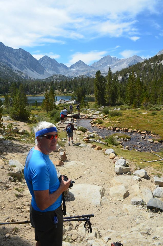
Someone asked me to post pictures from Little Lakes Valley in the Sierra Nevada, otherwise known as Rock Creek. This is an approach on the east side located between Bishop and Mammoth Lakes, and the road leaves west from Hwy 395 at Toms Place, a small hamlet with a fun restaurant and bar.
I have been going here for years, including staying at the cabins and lodge at Rock Creek, and snowcatting into that lodge in winter to cross-country ski. I have also roamed cross-country all over this valley to visit all of the lakes, and enjoying secret places off trail. This is one of the places where I have also hired packers for dunnage trips (mules and a packer carry your gear into your camp).
The east side of the Sierra is noted for is extreme variation in altitude. Most of the escarpment rises up steeply from Owens Valley at 4,000 feet to a continuous 50 mile jagged ridge that is rarely lower than 12,000 feet, with peaks to 14,000 feet. The Owens Valley basically ends just north of Bishop, and the highway climbs a huge slope up to Mammoth over the debris of the massive Long Valley Caldera eruption (Bishop Tuff). Little Lakes Valley is located at the northern end point of Owens Valley at the top of this climb.
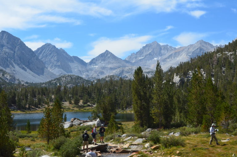
For most locations on the east side, getting into the high country involves a massive vertical gain, and the lower country tends to be hot, dusty and barren except for pretty riparian habitats extending into the near desert. But the road at Little Lakes Valley goes to 10,200 feet giving you immediate and easy access to the scenic high country of the Sierra.
It is special. The hiking is easy. You can walk in four to five miles and only gain 800 feet. You can tour the many scenic small lakes and lovely terrain, while never working hard. You can leave the valley to the west side over 12,000 foot Mono Pass, or as I have done, over cross-country passes to the west side (I hiked to Golden Lake and Pioneer Basin, which has a great view of the Mono Recesses).
I am also including a few pictures of another magical and easy place to visit from the east side — the Ritter Range just west of Devils Postpile.
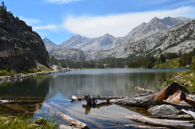
This is Heart Lake, the third lake in the chain and one of the prettiest. It is a little over a mile to get here and a very modest gain. The stream that flows to the lake is very pretty, as are the reeds and grasses that grow on parts of the lake shore.
Another view of Heart Lake. The first two lakes are Mack and Marsh Lakes, which are also nice.
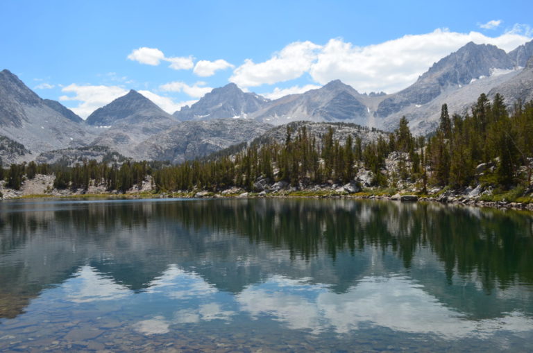
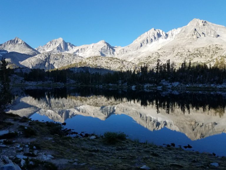
This is the fifth lake, Box Lake Long Lake, which is the largest. You pass Box Lake on the way here. You can see the trail on the left margin of the lake.
At the end of Long Lake, the trail climbs modestly to another series of more scattered lakes. A famous one is Chickenfoot Lake – the name is obvious if you look at the shape on a topo (a topological map).
I have camped and visited there many times, including in 2018. Another real beauty is Gem Lakes. There are two more lakes higher up (Treasure Lakes and Dade Lakes), but the terrain is more barren though still an adventure. This is all cross-country walking as there is no established trail, though sometimes use trails.
Chickenfoot Lake — I camp at this spot, which is a little more than 4 miles in and around 600 feet of gain. The color and quality of the light changes all day.
Morning light after the alpenglow has ended. Chickenfoot Lake.
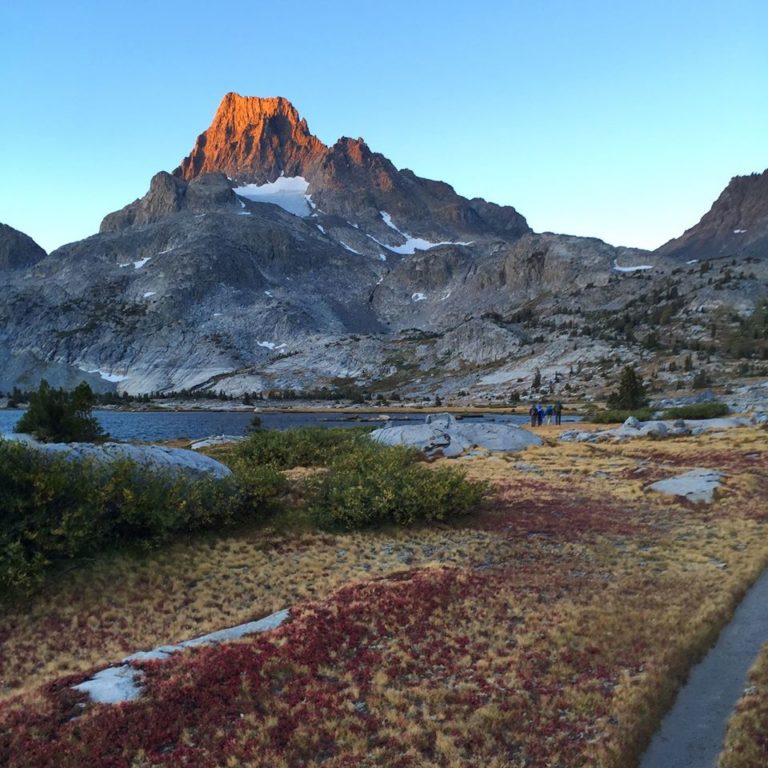
This is in the Ritter Range, which is another nearby place easy to visit. You get a great view of the Ritter Range when you drive through the Mammoth Mountain ski resort to the control entrance to Devils Postpile at the top of the crest. This is known as Minaret Vista at only 9276 feet, which is an unusually low spot on the Sierra crest. You can walk into the Ritter Range from various trailheads down in the valley below.
I camped at Thousand Island Lake after a long one day hike into that lake along the Pacific Crest Trail leaving from Agnew Meadows (the views on this route are stunning of the Ritter Range on the other side of the valley).
I have been here many times over the years. We are mountaineering this day to climb Ritter (13,149) via the Lake Catherine glacierette (which has shockingly melted back from 1982 when I first saw it). Ritter is hidden from view here by Banner, the peak just getting alpenglow on it, which I climbed in 1982. (It is a lot easier from the other side.)
The far western end of Thousand Island Lake is to the left — we have been walking about a mile from our camp so far. The route continues right to go up to the low spot on the skyline, and then turns left to walk up the glacierette in the chasm between the two peaks (immediate other side of Banner), and then strike up to either summit from the top of the glacierette.
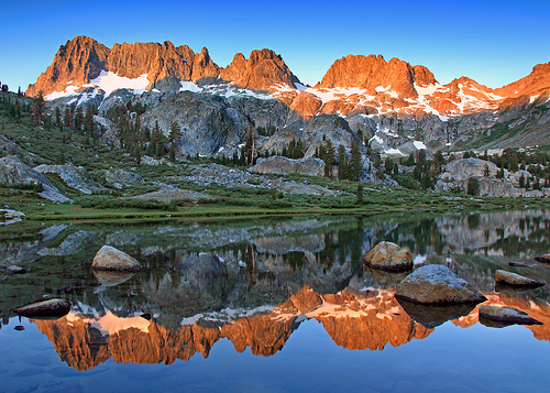
This is Lake Ediza in the Ritter Range, which is a long 7 mile walk in from Agnew Meadows. The gain is not bad – 1300 feet and more than half of it in the first two miles to Shadow Lake. That makes a great destination for those with less lofty goals, and Shadow Creek for the first two miles upstream from Shadow Lake is truly beautiful.
This short stretch is on the John Muir trail, which leaves Shadow Creek at about two miles up to go north to Garnet Lake. It is worth it to walk to the junction if Ediza is too much for one day.
On the trip for the picture above, we walked cross-country on the high route to the west of the lake chain from Thousand Island Lake, Garnet Lake (also beautiful), Nydiver Lakes to finally Ediza Lake.
On prior trips I had walked just over the low saddle cross-country to the country above Garnet, and then down the length of Garnet and down the outlet for the lake on the east to the River Trail.
I have also hiked into Ediza, and then south up to Iceberg Lake and Cecile Lake cross-country over to Minaret Lake, and out Minaret Creek. And I have done the same loop in reverse. The area is just wonderful and fairly easy.
?BillinGlendaleCA
I’ve been looking at Little Lakes Valley for the past few weeks, it looks really pretty. I wish I could get up there, but it would require an overnight and that’s not in the cards right now.
Isn’t the 3rd photo of Long Lake as opposed to Box Lake?
JPL
The reflections are beautiful. The humidity here has been unbearable and I can almost feel the crispness in the air.
Thank you for posting these.
Baud
That’s lovely scenery.
Eunicecycle
The sky and mountains reflected in the water is just beautiful.
EmbraceYourInnerCrone
These are so lovely to wake up to. Thank you for the beautiful photos and the descriptions of your hikes.
Living back east now I forget how awesome the views of the mountains could be.
eclare
Very beautiful photos!
UncleEbeneezer
Great pix! We did LLV on a lark several years ago and were absolutely AMAZED!! Might be the best bang-for-your-buck hike in the Eastern Sierra. We only made it as far as Heart Lake, iirc, because it was rather warm and our dog was getting tired, but you get some pretty spectacular views fairly early into the hike (unlike some other Sierra hikes where it takes a good 5-7 miles before you REALLY get the money shot views. This really is a special hike/place for all the reasons you mentioned. Thanks for sharing. This will be the first year in awhile that we won’t be doing an E Sierra trip, due to Covid-19 concerns.
For anyone who considers visiting LLV, there are also some really cute cabins you can rent near the trailhead that we have always wanted to try, and the little store/restaurant supposedly has the best pies in the Sierra. Also, if you take Rock creek Rd from Bishop to Tom’s Place (instead of 395), the scenery is really lovely. It adds about an hour to your drive but is really worth it if you’ve never done it before. It’s probably our favorite scenic drive in the Sierra, especially in Fall.
Wag
I love your reflection photos.
Betty
Just beautiful shots.
sherparick
Wonderful scenes and adding hiking the John Muir trail to my Bucket list. Looking at these locations, you may have seen them before if you watch a lot of Westerns, particularly the Anthony Mann pictures made with Jimmie Stewart in the lead in the 1950s. Here is a still shot from “The Naked Spur” which also starred Janet Leigh, Robert Ryan, & Ralph Meeker. https://encrypted-tbn0.gstatic.com/images?q=tbn%3AANd9GcTLSUCOs5ib3GB5UPselMGCexOfGP7dtDc9nw&usqp=CAU
J R in WV
Fascinating pictures, thanks for the geological explanation of the views along with the photos.
I love “On the Road” and I thank Alain and Watergirl for starting and continuing it every day. Thanks to all the people sharing their pictures with us, it’s a great way to learn about photography and all the places all over the world we’ve seen through On the Road.
From French Chateaus and Austrian fortified cities to — well, everywhere else we can see here. Amazing. Thanks!
BigJimSlade
Very nice! I think we must have left from that area when we did a loop by Lake Italy – beautiful, but cold, windy and rocky (must’ve stayed at Chickenfoot Lake first – it sounds and looks familiar), toward Lake Edison and up Mono Creek back to Rock Creek area. It’s pretty hazy as it was probably around 1980.
Tehanu
Lovely, thank you.
Dan B
Gorgeous terrain! The easy hiking sounds fantastic. The Cascades has a few hikes that are relatively easy: the Pacific Crest Trail north of Stevens Pass but it’s quite a few miles to open country.
Mike in Oly
What beautiful landscape! Thanks for sharing the pics.
dmbeaster
@?BillinGlendaleCA: LOL. Yes, and I know better. Editing error, as Box is the fourth lake.
WaterGirl
@dmbeaster: I made the correction from Box Lake to Long Lake.
Let me know if I goofed something up.