On the Road is a weekday feature spotlighting reader photo submissions.
From the exotic to the familiar, whether you’re traveling or in your own backyard, we would love to see the world through your eyes.
Today is the start of Chile After Dark – with lashonharangue – who will take us on a road trip to Southern Chile while we figure out where we want to go after Paris.
I’ll introduce the series with this first post, but will let the other individual Chile posts speak for themselves.
In this 8-part series, we’ll be treated to a story arc that starts from a place that had been developed for over a century, with paved roads and power poles, and tourist destinations with tour buses. We take a ferry ride and drive onto a gravel road in a rainforest, but the story ends at a place that is at the “end of the world.”
lashonharangue highlights how recent the Carretera Austral was (Chile’s own Rt. 66?) and how it is impacting the people/places in the south. He tells me that there have been a lot of environmental battles in Patagonia, and that ecotourism and adventure tourism are alternatives to more destructive economic development.
lashonharangue includes a fair bit of text to convey what the trip was like so that we might feel like we are along for the ride. He tells me that you can find as good or better photos of Patagonia online – but that’s not the point. His hope for the series is that we can share his adventure and see both the good and challenging aspects of all of it.
Let’s get started!
~WaterGirl
lashonharangue
Soon after retiring my spouse and I prioritized our bucket list trips. Top of the list was visiting Chile, specifically Patagonia. We flew to Santiago, spent a week there, and then drove south in a rented 4WD SUV along with our camping gear. It was the first time we had driven a stick shift in four decades. We spent four weeks camping and hiking through Patagonia, including driving most of the Carretera Austral in Chile, and ultimately reached Tierra del Fuego.
We stopped in several cities (Concepción, Valparaiso, Temuco) on the way to Puerto Montt, which is at the northern end of the Carretera Austral. This road, built by the Chilean army, was started in the mid-70s but its full 770 miles were only completed in 2000 at the small town of Villa O’Higgins. The road stops there because it is blocked by a giant ice field. Some of the road is paved, but much is a two lane gravel road, with sections connected across bodies of water by ferries of various sizes.
We spent a few days exploring the Puerto Varas area just north of Puerto Montt. We drove around Lago (lake) LLanquihue. You can see the influence of the german immigrants who arrived in the mid 19th century in architecture, food, and beer.
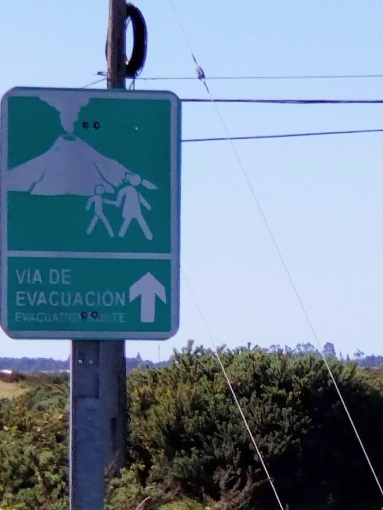
Compared to Chile, California is geologically tranquil. All the Chilean towns we saw along the Pacific had tsunami evacuation route signs. Signs for volcano evacuation were also a frequent sight. And major earthquakes are distressingly common.
I find signage fascinating. What is this image trying to communicate? It is important to hold hands when evacuating from an erupting volcano? Mothers don’t forget your child during an eruption?
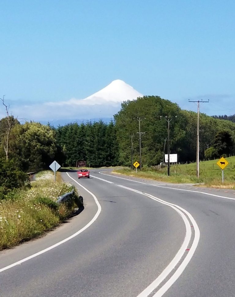
At first we would get excited when driving and see a snow capped volcano. Over the course of the trip it became kind of routine. An estimated 500 of the 2000 chilean volcanoes are considered potentially active.
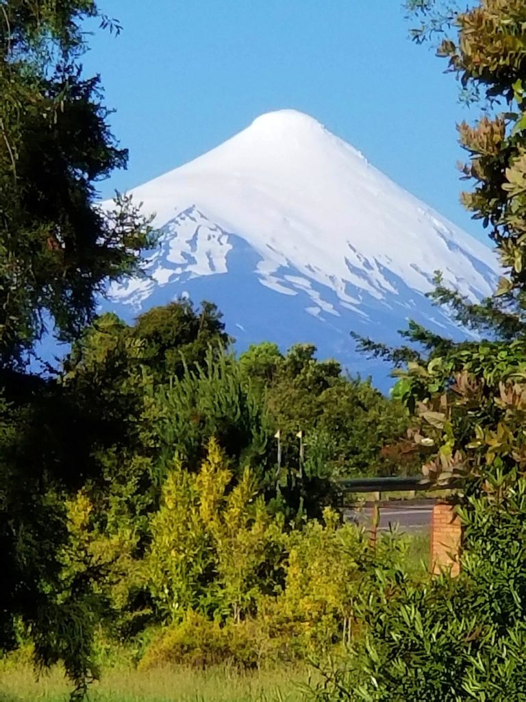
Imagine having this view from your house.
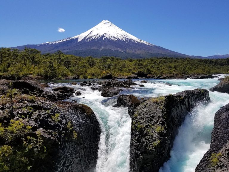
These falls are an easy hike from the park entrance. I managed to get a few photos without people in them. It was one of the most crowded parks we visited in Chile, with lots of groups on tour buses.
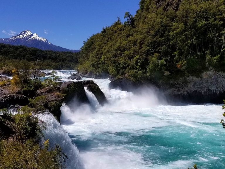
Same spot. These falls are to the right of the previous photo.
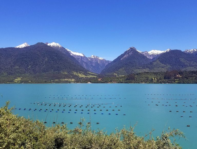
Salmon farming is a major industry in the Puerto Montt area. Fish farms were a common sight.
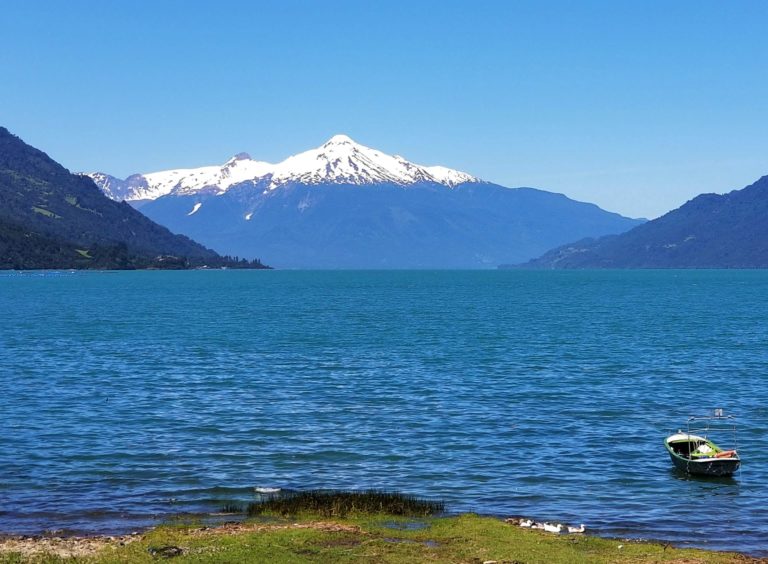
Duck family, boat, and snow capped mountain. I mostly rode shotgun and my main job was to say when to pull over to take another photo.
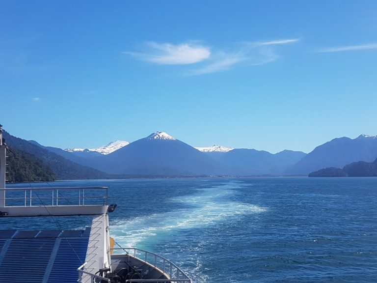
The ferry ride from Hornopirén to Caleta Gonzalo on the following day was about five hours. From there the road south was mostly gravel.
Lapassionara
Oh, my. These are wonderful. Thank you!
arrieve
Gorgeous pictures. I’ve been to Chile, but not Patagonia. I can’t wait to see the rest of the series!
Gin & Tonic
Would you take submissions from Argentinian Patagonia? Ruta 40 is their version of Carrera Austral, runs all the way down their side to Ushuaia (I only went as far south as El Calafate, but that’s south of O’Higgins on the Chilean side.)
WaterGirl
Love the color of the water. Did it really look that blue?
randy khan
It’s funny how something as beautiful as those snow-capped mountains can become routine. But lucky us – we get to see them with fresh eyes.
Yutsano
I honestly thought Kent was going to dominate this series! :P
You gotta love life in the Ring of Fire!
WaterGirl
@Yutsano:
I’m so out of it, I have no idea what that means.
frosty
Beautiful!! We spent 2 weeks in Santiago with a day trip to Valpairiso in the 90s. Always wanted to get to Tierra del Fuego but I don’t think it’s going to happen. Thanks for the pix! Looking forward to the others.
eclare
Stunning photos, can’t wait to see the rest!
Gin & Tonic
The Argentinian side looks a little different.
WaterGirl
@Gin & Tonic: Wow!
I wasn’t sure who the question in #3 was directed toward. If it was me, yes, send them in.
snarlymon
These are lovely photos. Now I have another place on my ever growing bucket list.
As a side note, during Charles Darwin’s voyage on the HMS Beagle they stopped in Chile and experienced a major earthquake. They measured around 5 feet of uplift in areas, which planted the idea that the marine fossils at the tops of the mountains were once on the seabed and were there because of uplift, not a great flood. It was an important clue that lead to his formulating his theory of evolution. Of course this was long before the idea of tectonic plates and continental drift became mainstream.
lashonharangue
@WaterGirl: I used some basic autocorrect tweaks with the image processing software that might have changed the water color a little. But as far as I remember it did look that blue that day.
Yutsano
@WaterGirl: The poster Kent. His wife is from Chile.
cain
@randy khan:
Bah! We see our beautiful Wy’east (Mt. Hood’s indian name) every day and every day it looks amazing. Like the mountain in Chile also volcanic and active :)
Wag
Great photos. I especially like the falls.
Yutsano
I love the snow-capped volcanoes. It’s like they’re toddlers sleeping in pure white blankets. That is, until they wake up and have the most massive meltdown in existence…
J R in WV
Wonderful photos… we’ve talked about visiting the antipodes someday. Llindblad / National Geographic does tours down south that way… Blue water is really blue in the Pacific!
Thanks for sharing the wonderful pictures of the wonderful volcanoes~!!~ Being into geology, volcanoes are in my sweet spot…
rikyrah
So beautiful. Brings back memories?
Auntie Anne
I am already loving this trip!
BigJimSlade
“Chile After Dark”
We just had a black bean chili, and it’s after dark, but I didn’t take any pictures :-(
Fortunately this post has some wonderful pictures!
SectionH
Absolutely fantastic pictures. I’ve got this post bookmarked so I can revisit.
Richard
Awesome. My old roommate got to go there for six months on a work exchange. They were building a trail in Torres del Paine which i think might be in Argentina but he was also in Puerto Montt. I’d love to see more.
donatellonerd
i loved the waterfalls even more than the snowcapped volcanoes. looking forward to the rest
Tehanu
Lovely, thank you. Looking forward to more!
Dan B
Wonderful photos that portray the awesome feel of the terrain. I’m in Seattle because of the Cascades, Olympics, ocean, Pudet Sound, and the volcanoes. One aspect of enormously tall mountains like Rainier arising from close to sea level is how the upper glacier clad elevations seem to sparkle. The air is only half as thick as sea level so the light is much more brilliant. It’s never grown old on me.
Anonymous At Work
“In case of volcanic eruption, walk calmly to safety.” Goes in my list of amusing street signs.
pluky
depending on how much ash is part of the eruption visibility can be as low as the densest fog one can imagine. holding on to one’s children is advisable.