On the Road is a weekday feature spotlighting reader photo submissions.
From the exotic to the familiar, whether you’re traveling or in your own backyard, we would love to see the world through your eyes.
Mike in Oly
Washington State is rife with incredible natural wonders, but one of the more iconic ones is Mt. St. Helens. It’s eruption in 1980 killed dozens, affected tens of thousands and fascinated millions. It was a boon to science as well, offering a smorgasbord of data in its wake, and remains a focus of study today. Just a couple hours drive for me, it is a favorite destination for day hikes and photography, and to take out-of-town visitors. Here are a selection of photos I’ve taken there over the years.
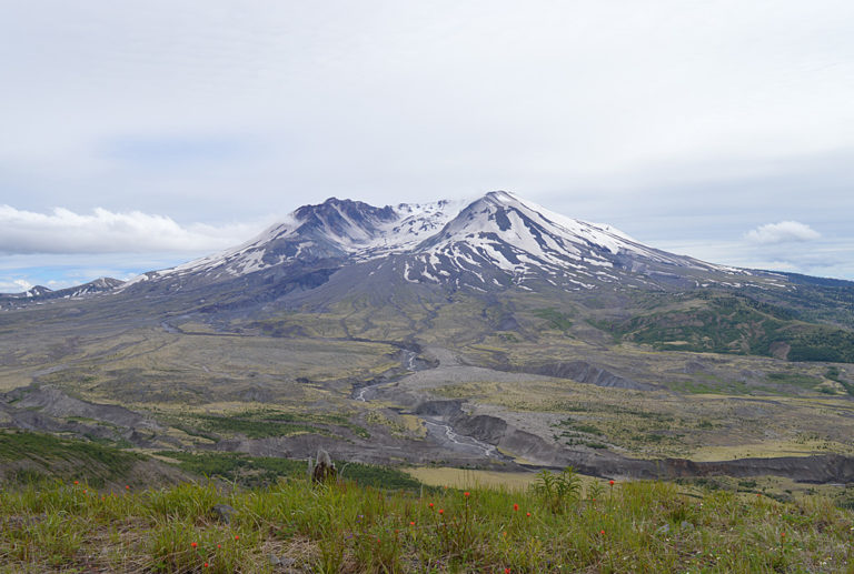
A view from the Hummocks trail. One of my favorite hikes in the area, it is only 3 miles and covers some really interesting terrain and offers nice views of the mountain.
Another shot from the Hummocks trail. The hummocks are a landform that used to be the mountain. They are the mass that was blown off and landed here so everything growing on them has colonized new ground.
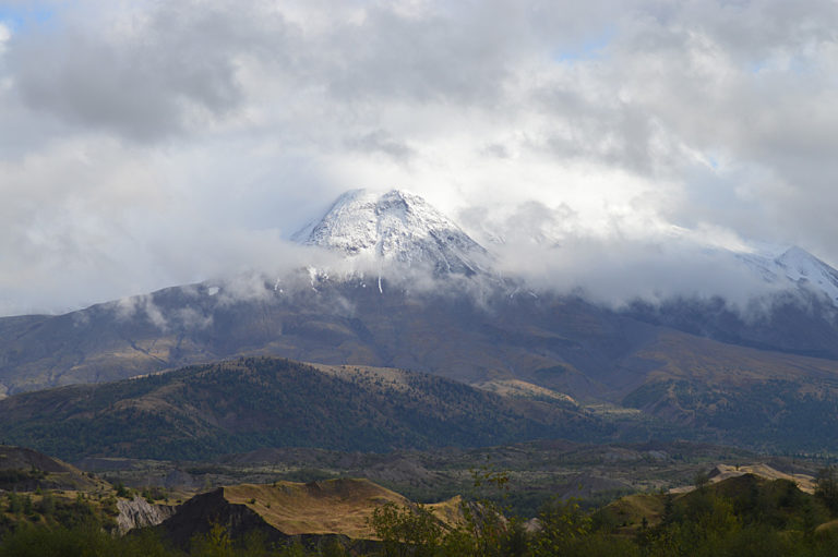
St. Helens shrouded in fog.
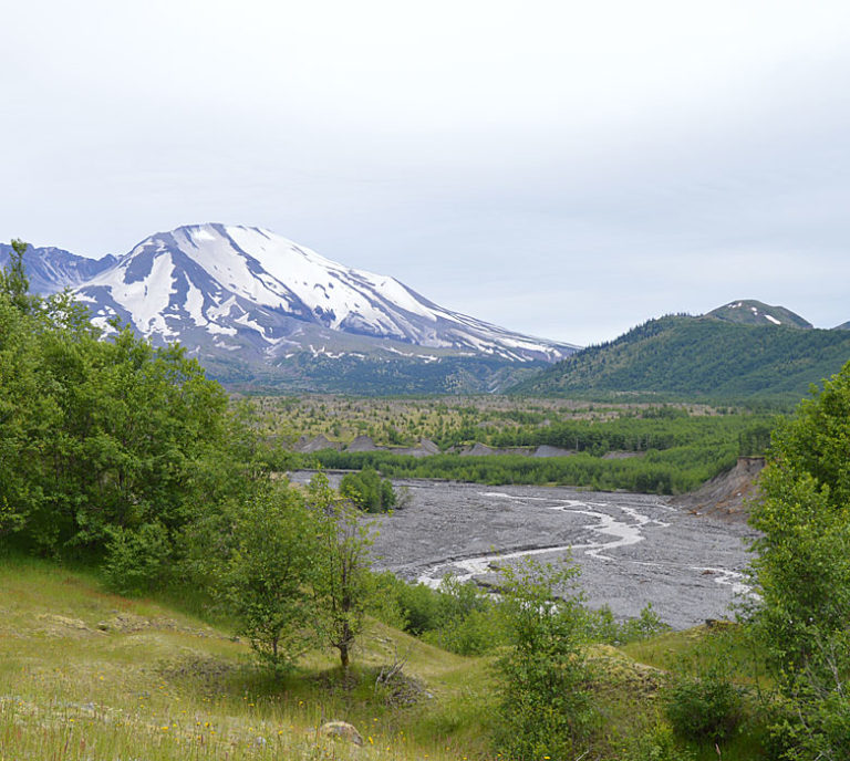
A view from above the Toutle river. You can see all the material that is still being moved downstream by water. A process that has just begun and will continue for centuries. Mitigation efforts have been made to try and keep a flood of loose material from hitting the Columbia River and disrupting shipping lanes, but it is only a matter of time before mother nature has her way.
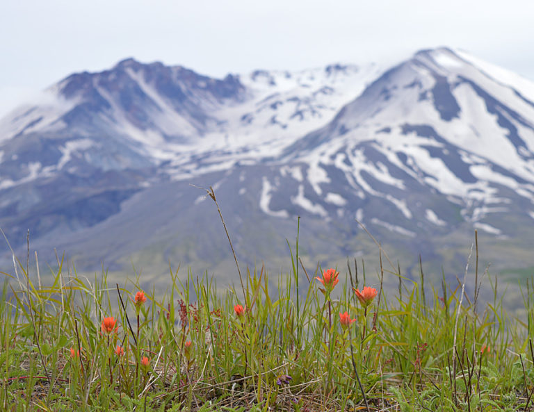
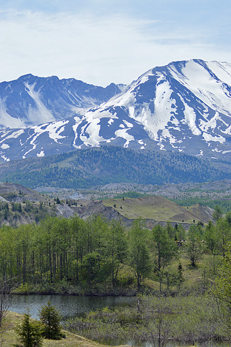
The wildflowers here are lovely. Not as profuse as the meadows of Rainier, but just as welcome with their splashes of color amidst the rubble.
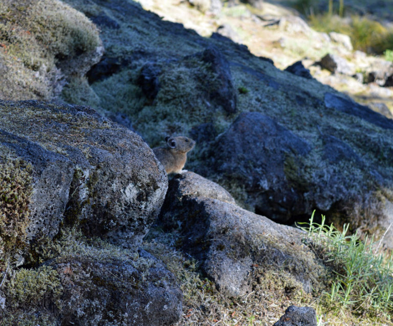
Along with the plants returning, the animals have also come back. Pikas are at home anywhere there is a rocky slope and plenty of wildflowers to harvest for hay.
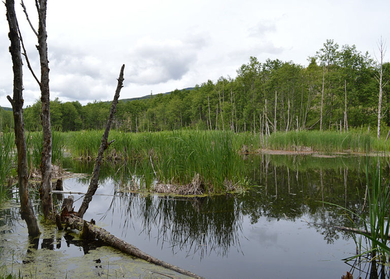
Beaver have moved in and created ponds, offering new types of habitat for other animals and plants.
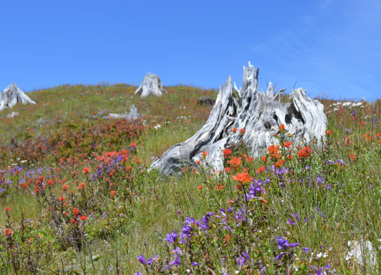
It is fascinating to see new biomes take over where once ancient forests stood. Their bones are still visible and the scars on the land abound while nature creates fresh life to fill the space created by the destruction.
JanieM
Stunning set.
Especially: thanks thanks for giving us a taste of the varied ways in which the area is evolving in the aftermath of the eruption. It makes me remember an exchange I had once with some people who wanted to get a group together and go plant trees after a fire, I think it was in in Yellowstone. Even by the time they were talking about it, the land was regenerating (for lack of a better word) without our “help.”
Wapiti
We went to Mount St. Helens in 2002 or 2003. It was interesting as we drove in we could see new growth and realize that we had passed into the blast area where the previous trees had been blown down. The visitors center was well worth the visit.
BigJimSlade
Fine shots – thanks for posting!
oclib
I was living in the OC when St. Helens blew in May of `80. Took the train up in July for my 10 year HS reunion in Tigard. Someone tried to sell me a vile of ash when I got off the train as I noticed there was still a fair amount of ash on the ground. As one would expect, St. Helens was the main focus of talk at the reunion. One classmate lost his cabin on the Toutle river. I think he was the only one of the class that suffered any real damage from the eruption. Good pics btw….
TheOtherHank
My mother and I drove from southern Oregon to Wisconsin that summer and drove through the area where the ash had fallen. More than one truck stop we stopped at little vials of “Authentic Mount Saint Helens Volcanic Ash” for sale. Or you could go outside and get as much as you wanted from the ditch next to the road.
Matt McIrvin
My great-uncle and great-aunt Harvey and Virginia, who lived in Yakima, eventually had a period of nomadic retirement in which they spent some years touring the country in an RV. I recall meeting up with them at one point and Harvey had these jars of St. Helens ash he’d collected at different places after the eruption, was always hauling them out to demonstrate the differences between them…
Mary G
Love the wildflowers next to the blasted stumps! Nature does abhor a vacuum. I had a botany major friend who could date fires within a month or two just by looking at what stage the regeneration was in.
Gary K
Question about how the site operates: For posts which don’t appear completely on the front page, there is an option “show full post on front page.” That doesn’t happen, however, with On The Road posts. Why?
weasel
@Gary K: Good question! Been wondering the same thing and hope it is just a template tweak that is missing :)
Benw
Wonderful pics and story. So interesting that we’re watching geology in “real time”
Origuy
Thanks for the pictures. I stopped by Mt. Saint Helens in 1986, I think it was. I saw the mountain and the temporary visitor center. There were still a lot of downed trees and areas covered in ash. A few areas were starting to get green. The next time I was there, about 10 years later, the current visitor center and the Johnston Observatory were open. Neither time did I have any time to see much wildlife.
stinger
What great images, and what a story they (you) tell!
Yutsano
We moved to Washington right after the eruption happened. There was ash EVERYWHERE. We collected it and stuck it in Christmas ornaments. The growth back is amazing, if the trees are taking their time.
CaseyL
Love seeing the Mt St Helens region environmentally regenerate. Fascinating that the Hummocks just sort of flew through the air and took root where they landed – hard to imagine anything surviving the eruption like that!
I drove through the area with some friends back in the early 90s. It’s one thing to read about the devastation, even to see photos of it, but driving through miles and miles of rolling hills covered with downed trees – even 12 years later! – all pointing the same way, was entirely different. A transcendent experience.
Bonnie
I still remember the eruption as if it were yesterday. My cat was acting funny, which was the only different thing in my life when I got up that morning. It was a Sunday morning on May 18, which was my paternal grandmother’s birthday. She had died some years ago; but, almost everyone in my family felt Grandma was around us–maybe keeping us safe. It wasn’t until a couple hours later when I turned the TV on. There came a very harrowing filming of the eruption by a local reporter who was up there because an eruption had been expected. He had a camera; but, we could only see brown clouds of smoke while he was trying to get as far as possible away from where he was. He narrated his escape; it was riveting. I think he finally found somewhere to hide for a while as the smoke and ash permeated the area. I wonder now what local station he worked for and if that recording is still available. I was glued to the TV and wouldn’t let my cat outside, which made her a bit cranky. I was living on Queen Anne hill in Seattle at the time.
JustRuss
Did some backpacking there a few years ago. There were wild strawberries growing along the trail, tiny, about the size of the nail on my pinky. And incredibly delicious.
Tehanu
Nice pics, thank you. I have two round glass Christmas tree ornaments made from the ash from the 1980 explosion and I’ve always wanted to go up there and see it. Maybe once the pandemic is over.
Tdjr
I stood on the ridge at the visitors center and looked at the mountain 5 miles away. It took milliseconds for the blast to reach where I was standing. It made me realize what real power is. Awesome!
Dan B
Three of us were getting on the Lady of the Lake ferry at 25 mile on Lake Chelan at 8:30 AM on the 18th. Lake Chelan is a glacially carved inland fjord on the east side of the Cascades. It’s 50 miles long, 1100 feet deep, and a mile wide, flanked by 7,000 to 9,000 foot tall peaks. We heard big shotgun or small cannon fire from the hillside above. It was weird because the “hillside” was an uninhabited mountainslope. We got off the ferry 8 miles north to hike the lakeshore trail. After navigating many rattlesnakes emerging from hibernation we set camp at Hunt’s Bluff, a high bluff that looked down and up most of the Lake. We heard many “gun” blasts. A mile thick cloud of weird looking fog filled the southeast end of the lake as strange blackish clouds raced overhead.
The next afternoon we hiked into the little store at Stehekin. The clerks were conversing. One said, “Harry’s dead.” We asked, “Who?” The reply was,” Harry Truman! The mountain exploded!”
We didn’t believe what we were hearing but on our drive back to Seattle all the garbage cans were full of air filters. It was “dense fog” at 80 degrees. The entirety of Eastern Washington was filled with ash as was the air for many thousand feet.
A friend of mine told everyone I’d been hiking at Mt. St. Helens and had died. I guess he was surprised.
Dan B
Pikas are crazy cute and endangered by climate change. I went hiking at Hart’s Pass with a partner who had a Jack Russell terrier. One trail traversed miles of rockslide covered slopes. Pikas / Cuny’s were everywhere. “Jack” was nuts. Without a leash we would have never seen him again.
pluky
@Yutsano: Restoration of climax forest can take centuries.
namekarB
Stunning!
JoyceCB
And many miles to the east, about three days later, we woke to find our cars covered with a very thin layer of “dust”, which of course was tiny bits of the mountain carried all the way to Toronto.
Anonymous At Work
@Wapiti: I went with family a few years before that and we marveled at the places untouched by the blast, including a few stands of trees close to the mountain itself. Lush, dense green amidst the still-desolate moonscape.
WaterGirl
@Gary K: The posts are created with a form, and I asked them to always display only the first photo on the front page.
WaterGirl
@weasel: The form was designed and created before I added the request to add “show full post” for longer posts on the front page.
I think OTR is nicer the way it is, so it never occurred to me to ask for the option to show full post!
JanieM
I have a question about the hummocks, if anyone is still checking in. I thought Mike in Oly meant that the growth we can see on them now is all new since the eruption. CaseyL’s comment made me wonder if I’m misinterpreting (or maybe I’m misreading her comment) — those hummocks didn’t fly through the air with their former growth still intact, did they? Or did they?!?
JanieM
@WaterGirl: I never even noticed that it was different. I never use the “show full post on front page” because I just click to see the comments and it has more or less the same effect. (Doesn’t it?)
WaterGirl
@JanieM: If you “show full post on front page” it shows the whole post, but not the comments. Then when you are done reading, you can click “show full post…” again and the post shortens up again.
If you click on “Post + Comments” then you GO to the post itself, and you see the full post AND you see the comments.
J R in WV
We visited Yellowstone in 1991, after some big fires had destroyed some forest around the park in 1988.
While we saw area with huge black poles sticking up, former pine trees, the ground around those black charcoal sticks was vibrant green in the week before Memorial Day. And just FYI, as we were leaving Jackson’s Hole on Memorial Day weekend heading south to fly home out of Salt Lake, there was a string of traffic, RVs and cars bumper to bumper for miles uninterrupted heading north towards the Grand Tetons and Yellowstone.
We had a great visit, while there were plenty of people around, it wasn’t crowded anywhere, not even Old Faithful. In many places there were more buffalo than people…. Signs everywhere warning tourists to keep their distance from the buffalo who can convert from immobile to charging at 35 mph in under a second. Tourists everywhere ignoring that danger!
It was obvious how quickly the forest was going to recover from the 1988 fires. SOP for western forests.
@CaseyL:
Nothing you see survived the eruption. The hummocks were piles of raw volcanic stone and earth that were inside the volcano, blown away by the violent explosion, barren and steaming after the eruption. What you see now is what has taken root since then from wind blown seeds and seeds dropped by birds into the cooled ash.
JanieM
@WaterGirl: Heh, I never even tried it [[[ETA: “it” being “show full post on front page”]]], obviously. I thought it would show the whole post and the comments, but without the left and right arrows for navigating between posts. And what would be the point of that?!?
Tastes differ. ;-)
Good thing I don’t have your job….
Gary K
@Bonnie: It was probably Dave Crockett of KOMO. See this Scientific American blog and this video.
way2blue
Years after the Mt St Helens eruption, I attended a briefing at CVO. A dome was building on the floor of the volcano and the CVO scientists wanted to sample fresh volcanic rock through time to see if/how the chemistry changed… Anyway. This required a helicopter ride into the volcano, someone running up to the volcanic dome with a bucket, breaking off a chuck of fresh lava, and rushing back to the helicopter (whose pilot kept the rotors spinning). We all stared at the colleague in disbelief, saying ‘but you have children… ‘
Mike in Oly
@JanieM: As for ‘flying thru the air’ they did and they didn’t. The Hummocks are composed of the raw stuff that used to be the mountain before it exploded. My better half tells me that rather than just going up and coming down in a new place, the material was blasted out sideways where it slid over a layer of superheated gas, banked off a ridge and finally slumped well down valley. (About 8 miles, if memory serves). All the growth on it is is completely new. Nothing survived in this material. There are other pockets around where old stuff did hang on, but the Hummocks are fresh terrain being colonized naturally.