On the Road is a weekday feature spotlighting reader photo submissions.
From the exotic to the familiar, whether you’re traveling or in your own backyard, we would love to see the world through your eyes.
Athenaze and Ariobarzanes
In early June 2021, we decided to take our fully vaccinated selves on a trip to Greece. We spent a large portion of our trip hiking on the island of Andros. We have spent a lot of time in Greece, but mostly on the mainland. Neither one of us has spent a great amount of time in the islands, nor had we been to Andros.
Andros, the northernmost island of the Cyclades, is only a two-hour ferry ride from Athens’ secondary port, Rafina. In spite of its proximity to the capital, however, it does not host a lot of tourists, most of whom prefer to spend their time on better-known islands like Mykonos and Santorini. For that reason, it feels much more relaxed than some other islands. It feels like what it really is: a place where people actually live.
That said, Andros is now an excellent hiking destination thanks to the efforts Andros Routes (link), a volunteer organization dedicated to promoting sustainable tourism on the island. In recent years they have done a lot of work clearing, rehabilitating, and marking the island’s footpaths, many of which have been used for centuries to connect the villages of the island with one another. The trail network has recently by recognized by the European Ramblers’ Association. It is possible to link segments together into a through-hike, as we did; we walked for almost 100km over six days with the assistance of a local travel and adventure company that helped with route planning, hotel planning, and baggage transportation from one hotel to another.
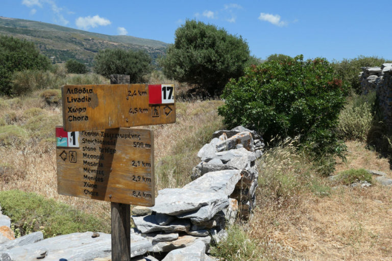
We cannot overstate the amount of work that the volunteers at Andros Routes have put into marking the island’s network of footpaths. Major junctions are clearly signed in Greek and in English, like this junction of Trail 1 and Trail 17a near the village of Menites in the center of the island. The individual trails are also all marked at regular intervals with numbered red and white blazes like those you see here on the signpost.
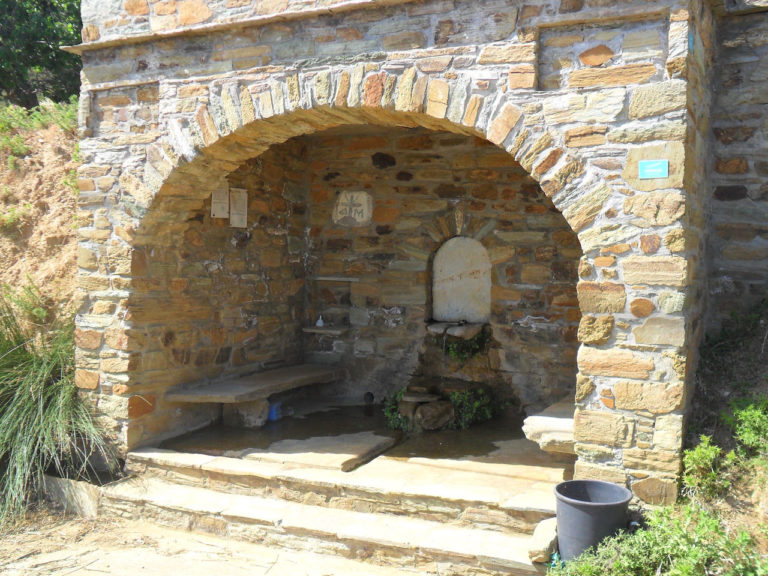
Temperatures on Andros can soar in the summer, as they can in Greece in general. During our hike in early June, daytime highs ranged between the mid 70s and mid 80s, but the “real feel” was sometimes up to ten degrees higher. As a result, we often drank more than three liters of water each per day. Fortunately, Andros has numerous springs, which locals have exploited for centuries. This picture shows one of the many fountainhouses that draw from those springs and make water easily accessible to villagers and hikers alike.
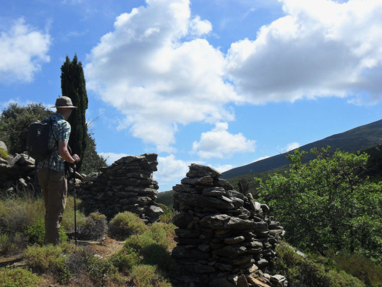
Andros is the best-watered of the Cycladic islands, which as a rule can be very arid. The island’s valleys in particular can be lush and green. In this photo, the path passes a break in an old field wall, where hikers (like Ariobarzanes) can look down into the Frousaioi Ravine, located in the northern part of the island.
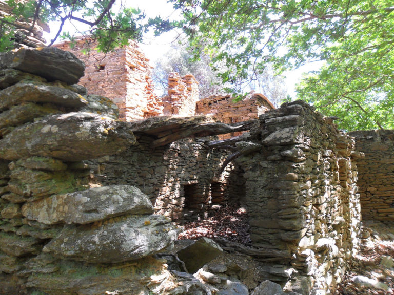
Until the 1960s, the watercourse in the Frousaioi Ravine had powered a number of watermills where locals could mill their grain. There were enough of these to form a village of millers. The mills and houses are now abandoned, but Trail 14 takes visitors along the watercourse and through their ruins. This is one of the many ruined millhouses we saw as we followed the trail.
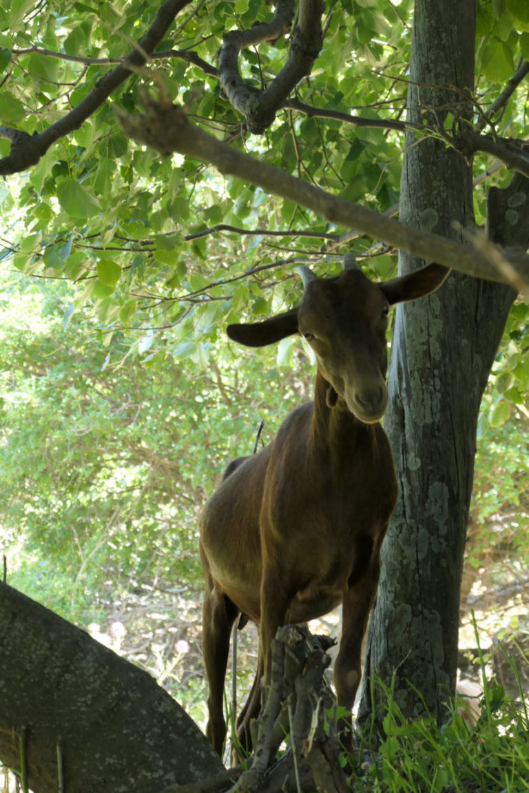
We saw lots and lots of goats during our hike. Most tried to avoid us by running away, especially in remote areas where they seemed semi-feral. This one, which we encountered in the village of Arni on the last day, was more inquisitive than most.
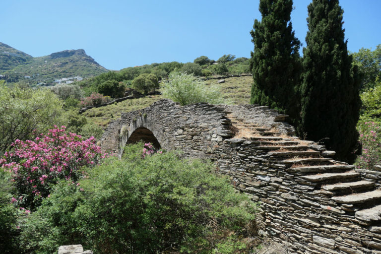
This stone bridge dates from the sixteenth century, and currently carries Trail 1 across the bottom of a valley in the center of the Island. Like much of Greece, Andros was occupied by both the Venetians and the Ottoman Empire at different points in its history. The Venetians were present on the island from shortly after the Fourth Crusade of 1204 until the late sixteenth century. This bridge, along with important roads once paved in broad flagstones that now serve as hiking trails, was built to connect main nodes of Venetian settlement.
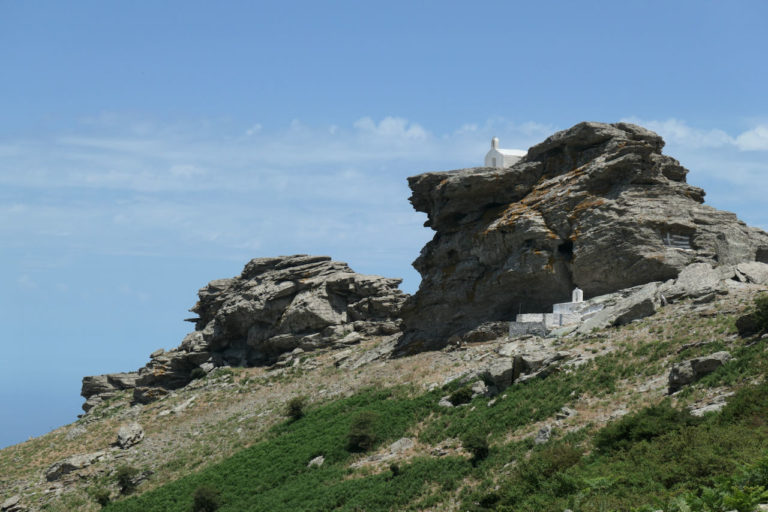
The chapel of Profitis Ilias (Prophet Elijah) sits on top of a rocky outcrop on the shoulder of the island’s highest mountain. It towers roughly 900 meters above the valley of Arni. Dozens of small chapels like this can be found all over the island, sometimes (like this one) in very remote places. Profitis Ilias is the most common figure to whom chapels on ridges or mountaintops in the Greek islands are dedicated.
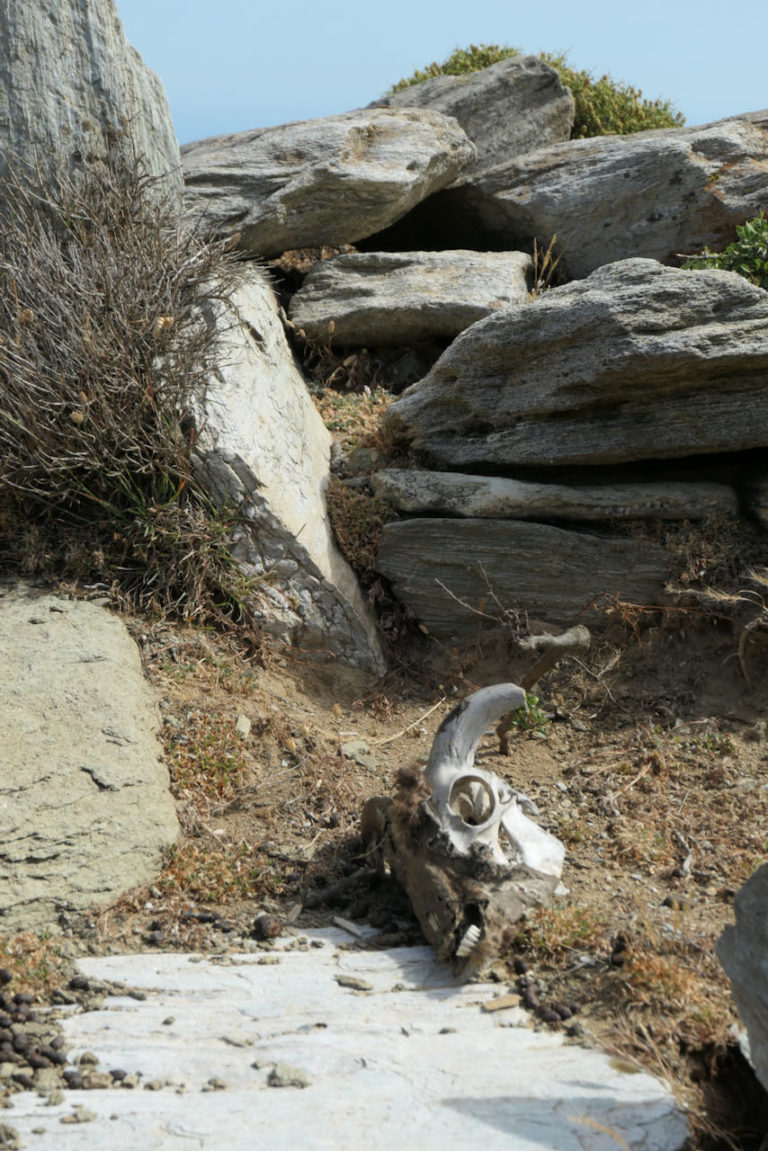
Again, we saw lots and lots of goats. Not all of them were alive. This one came to an unfortunate end on the island’s highest mountain, not too far from Profitis Ilias.
SiubhanDuinne
Some fascinating history. I love that there are so many tiny chapels on the island dedicated to the prophet Elijah.
And I’m very partial to goats. The one you photographed (the live one, not the Georgia O’Keeffish skull) is a lovely picture. The ears!
Van Buren
Nice. My kind of trip.
HeartlandLiberal
As a long time student of language and linguistics, would like to point out that sign in first picture is perfect example of how, when you say the phrase ‘lingua franca’, it no longer meets French as the common language of communication, it means English. Take that, Frenchies.
TheronWare
Now that’s a vacation! Really enjoyed the photos and story to go with them, thank you.
Geminid
A lot of up-and-down walking! Looks like the hiking and the three liters of water were worth it. Thank you for the pics.
The Christian shrines may have been built over older ones. I wonder which gods or demigods they were dedicated to in pagan times.
Anastasio Beaverhausen
I am a veteran hike and would like to get more info. Who did you use for the planning? One Foot Forward? Thanks.
Anastasio Beaverhausen
Who did you use for planning? One Foot Forward? Thanks!
Spanky
Somebody put a toy church on that pile of rocks! That picture seriously messes with one’s sense of scale.
I see there’s an (obviously big) Greek flag painted on a flat section below and to the right of the church. Shadows make it impossible yo tell if that’s the only one.
Ariobarzanes
@Anastasio Beaverhausen: Yes; that’s the provider we used.
Wag
Excellent photos, and now I have a new goal for retirement!
stinger
@Ariobarzanes: Thank you — I was going to ask that as well — how to get started on planning such a trip from the western side of the Atlantic. These are fantastic pictures — I can smell the air and hear the crunch of boots and feel the breeze.
Athenaze
@Spanky: There’s only the one flag painted on the rocks. Actually, it’s the only example we saw on the trip.
arrieve
Wonderful pictures. That chapel on the rocks!
Ariobarzanes
@stinger: One Foot Forward is definitely the easiest option.
There’s a first-rate map available through Anavasi if you want a look at the routes (though if you plan through One Foot Forward, you’ll get a copy as part of the package).
frosty
Very cool hiking! I like the idea of forwarding your baggage ahead. 100km in 6 days works out to 10 miles per day, which isn’t too bad even for us more elderly hikers. I wonder if something like this can be set up in the English Lake District.
Neldob
Wow, nice walking and such interesting surroundings. Now I want to go there.
Ariobarzanes
@frosty:
My sense is that the UK is already well-served by companies like this; when we last did a through-hike in northern England (2018), we were the only fools carrying our own gear.
In Greece, however, they are very much a novelty, and the one we used on Andros is actually the only one that I know.
way2blue
What a wonderful trip. I hope to return to Greece before too long. Thanks for the photos and your descriptions of what you encountered along the hiking trails.
krackenJack
Ariobarzanes: Your post is a great mix of pictures and information. It takes a lot of time to put that together. I also appreciate the amount of effort required to clear and maintain the trails by Andros Routes. I’m sure it will have a long lasting, positive impact on the local economy.
J R in WV
Goats — we have many good friends who keep or have kept goats — they are perhaps the most alien domesticated critters found commonly, though Europe used to have some really strange critters we met on a trip to the Pyrenees mountains of NE Spain and SW France. Those eyes!!
Great pictures of a fascinating landscape. We have Greece and those islands on the infinite bucket list! Thanks for all the info with the great photos!!
A woman from anywhere (formerly Mohagan)
I took an archeology tour of Santorini, Crete, and the Greek mainland in May 2018, and it was definitely warmer (i.e hot) than I had been expecting. The mainland was more humid than the islands, but both were warm to hot. I did not wear any kind of second layer (jacket or sweater) from when I got off the plane in Santorini on arrival to when I got on the plane in Athens to go home. And this was in May. I can’t imagine what Greece is like in the summer heat.
anastasio beaverhousen
@frosty: I’ve used Encounters Walking Holidays for 6 different trips. They are excellent for English hikes
Athenaze
@A woman from anywhere (formerly Mohagan): @A woman from anywhere (formerly Mohagan): I spent a couple summers (June-August) in Athens, and it gets pretty hot. Upper 30s or even low 40s Celsius (upper 90s, low 100s) on a regular basis. One of those summer was spent on an archaeological dig, and we worked 7am-2pm. But our apartments didn’t have AC either summer. Back then, 20 years ago, AC was not so common in Greece. So, you learn to cope. You embrace the fact that you’re going to sweat all the time. On the dig I would carry 2 1.5 liter water bottles; one would come from the fridge and one from the freezer. That way, by the time I finished the fridge bottle, the freezer bottle would be partly thawed but still cold. But, it is a dry heat, and that does make a difference. It didn’t feel anywhere near as miserable as humid summers in Virginia, even if it was hotter.