On the Road is a weekday feature spotlighting reader photo submissions.
From the exotic to the familiar, whether you’re traveling or in your own backyard, we would love to see the world through your eyes.
TKH
In mid-July I started a through-hike of Roper’s Sierra High Route in California’s Sierra Nevada. It ended not being the projected through-hike because of the three fires in the Yosemite area which were only partially contained when I bailed and on occasion filled the air with smoke and the stench of burn. I did not feel the need to go out of my way to coat the inside of my lungs with soot particles. The Sierra will still be there next year and, having had such a great time this year, I will be most happy to return to complete the Northern third of the route.
The Sierra High Route is a 180 mile route from Kings Canyon NP on the West side of the Sierra to Twin Lakes near Bridgeport on the East side. In a way it parallels the more well-known John Muir Trail, the main difference being that the JMT goes through the valleys and is a bona fide maintained trail while the High Route, as the name implies, stays as high as possible, rarely dipping below 10k ft, and is mostly off-trail. Both routes share short stretches of trail near Mather Pass, near Mammoth Lakes and near Tuolumne Meadows.
Most passes one crosses on the High Route are in the 11.5 k to 12.5 k ft range. Most have a reasonable side and a steep side, some have a heart-stopper side that takes a significant amount of the courage you can muster. This can be due to grade, i.e. steepness, or the kind of ground you have to walk on, which can be loose sand mixed in with loose rocks of fist size and below, aka “scree”, scree only or “talus”, rocks between briefcase and washer/drier to small car size, and combinations of the three.
I am in my late sixties and I can no longer schlepp the heavy packs I used to carry without complaint in my youth and early adulthood into middle age (I did not know any better and the modern ultralight gear had not yet been invented nor was it on the horizon). So my equipment is stripped down to the bare bones plus food and water. I therefore only carry an iPhone as my camera and not any more fancy equipment. I can therefore not compete with the production values of Bill in Glendale or other photographers’ on BJ, my apologies.
It was my first time in the Sierra Nevada. If my luck holds up (and the knees, don’t forget the knees!) I will be back next year to complete the route and the Southern Sierra High Route, which is a bit more difficult but, I now know, within my reach.
Happy trails!
Thomas
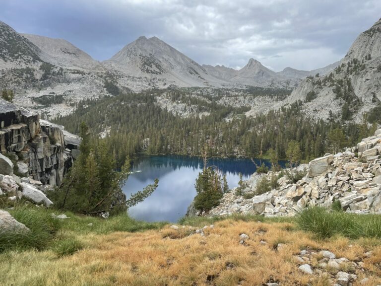
Marion Lake, named for Marion LeConte who, with her husband Joseph LeConte, was one of the early explorers of the Sierra Nevada in the late 19th and early 20th century. The lake has a reputation for its unreal blue color and even on this overcast late afternoon the color did not disappoint.
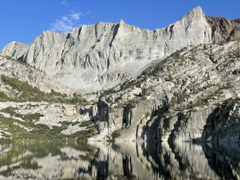
View of the South shore of Marion Lake from the outlet stream. Notice the sharp boundary between the white granite and the reddish, iron-containing rock on the horizon.
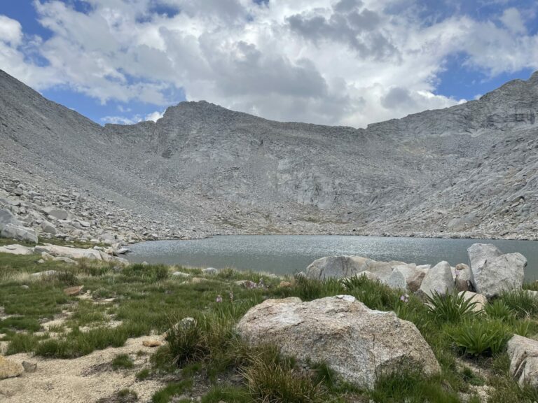
This is the South side of Frozen Lake Pass, the “easy” side no less. the pass itself is the little notch on the left that looks like an L tilted to the left. It is “pick your own adventure”-type ascent. As you find your way up you think “this is the easy side, remember!”
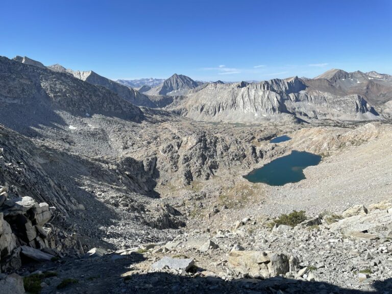
A last look back from the pass at 11600 ft to where one comes from, Sequoia and Kings Canyon National Parks are somewhere out there.
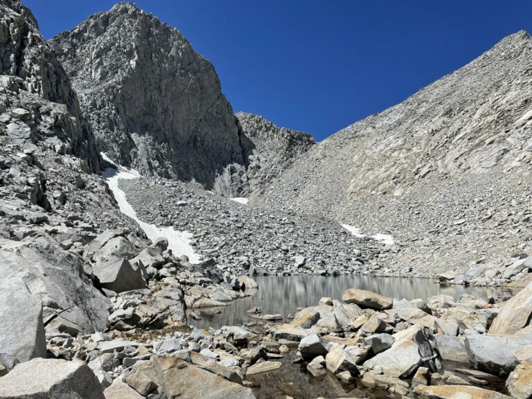
The descent lived up to its reputation. The pass is the lowest notch slightly off-center to the right. I did not dare stop and take pictures while climbing down. Here the slope flattens out at the shore of Frozen Lake. You continue to scramble across the jumble of rocks to another precipice located at my back as I took this picture.
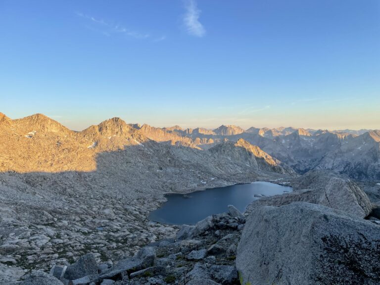
A look back at nightfall from a pass below Mt. Jepson. California, the Golden State, lives up to its reputation (even though this nickname does not originate from alpenglow like this).
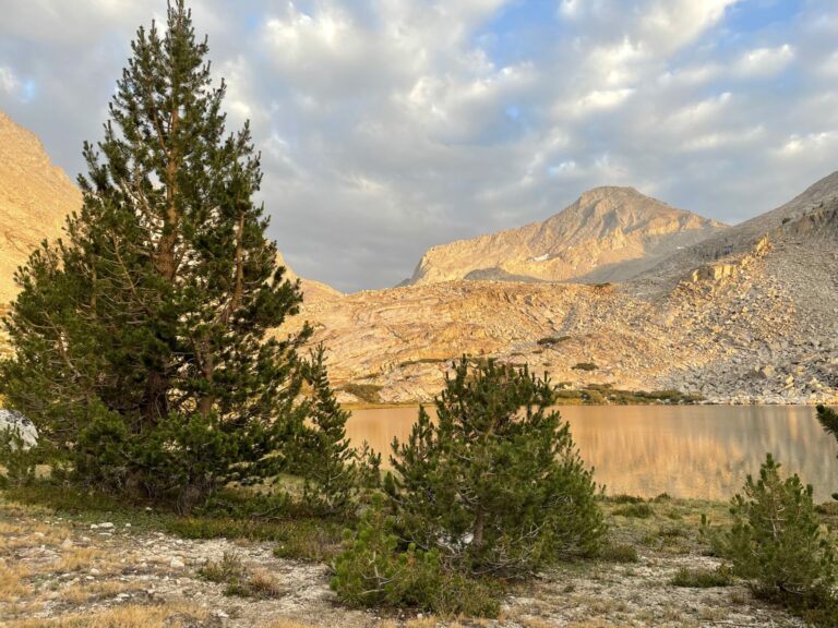
Evening light at my camp on the shore of Lower Mills Lake. It had been a long, difficult, and exhausting day, but views like this make the day’s challenges disappear instantly.
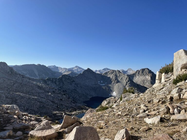
Every day, with one or two exceptions, would start like this, with a perfectly blue sky. By about 11 to noon the clouds would move in for a partly cloudy afternoon and in the early evening the skies would clear up. the night sky was just fantastic, the Milky Way as distinct as a car’s headlight in the night. While I did put up my tent, i mostly cowboy camped under the stars.
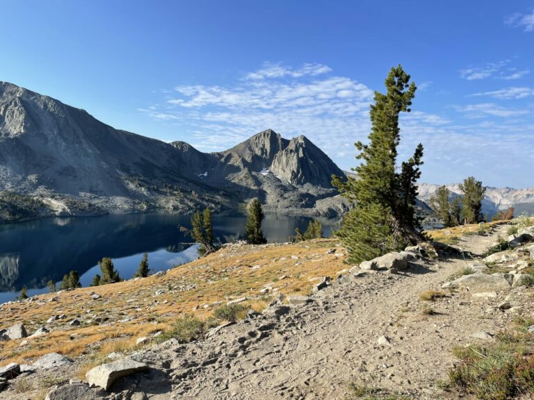
As you near Mammoth Lakes the Sierra High Route joins the John Muir Trail and the Pacific Crest Trail for a couple of miles. This is the end of splendid isolation and solitude, but this early morning above Duck Lake as I ascended to Duck Pass was perfect nonetheless.
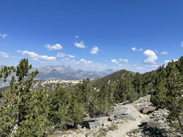
In the far distance you see the Ritter range, which I would be hiking though a week hence. Because of the fires I chose to not go there this year, hoping to have better luck next year.

raven
Great stuff, I stumbled around triple divide pass many moons ago!
raven
I went back an looked at the pics we took 20 years ago with a clunker digicam, these are great!!!
Anyway
Fantastic – both trip and pictures. How many days were you out with your backpack?
Baud
Excellent hike.
Laura Too
Lovely pictures and great descriptions. Thanks!
Van Buren
Beautiful.
BretH
“Please excuse me that these absolutely stunning and beautifully framed photos were taken with a lowly iPhone.” LOL
Dorothy A. Winsor
What a beautiful place
Betsy
So very beautiful. I think you do a wonderful job with a mere iPhone! Calendar-worthy shots in several cases.
Albatrossity
Stunning images of a wonderful place. Looking forward to next year’s installment!
Betsy
So very beautiful. I think you do a wonderful job with a mere iPhone! Calendar-worthy shots in several cases.
Kevin
@BretH: I was thinking the same thing. Stunning hike. I can hear the peace and quiet from where I sit.
cope
Great pictures of stunning views, thank you.
Were you alone throughout this trek? I’m curious about this because in my experience, solitary hiking/camping/trekking is a good order magnitude more fulfilling.
MazeDancer
Remarkable photos
mvr
These are great photos especially because of the colors and the light. Also make me think that on 64 yo knees I might not get through this hike. Right now my ambition is to lighten up my gear enough to hike into the Grand Canyon of the Yellowstone and fish. My right knee is not so sure.
Thanks!
TKH
@Anyway: projected 18 days for the 180 miles. Coming from sea level this was a bit ambitious in the beginning. With the shortcut I was out 13 days, which left enough time to linger ans take in the scenery
TKH
@cope: yes, this was a solo trip, like all my long distance hikes. Part of this is a practical consideration, I just don’t know anybody roughly my age who is up for this. Ans second, I really do enjoy the solitude.
TKH
@mvr: my base weight is 13 lb, so not ultralight, but light enough. Add seven days of food (16 lb), a liter of water (2 lb), a bear cannister (2.5 lb) and fuel (0.5 lb).
the modern gear is just amazing, in what you get for a pile of cash. It’s just like bicycles, the less they weigh, the more they cost. But my 68 yo knees would no longer play along with the loads I used to carry.
I am just heading to the Grand Canyon to hike along it.
Kristine
Lovely photos.
Phone cameras really are pretty good.
TKH
@mvr: By the way, knee strengthening exercises have done a minor miracle for me. I had a bum knee from military service and after a couple of months of daily exercise the knee is at least cooperating with my hiking agenda, if not exactly enthusiastically so. Might work for you too.
Raven
@TKH:
My 72 year old buddy tried the Washington end of the Pacific Coast Trail last year but had to bail 100 miles in.
Wag
That looks like my kind of country. I can’t wait for retirement and I’ll have time to head out to California to explore.
TKH
@Raven: I saw some people on the stretch of my hike that overlaps with the John Muir Trail that were a few years my senior. The load they were carrying was way too high, well above 50 lbs. And I could kinda sympathize, when you reach that age you may be hard pressed to justify buying ultralight gear. But without light gear, it’s hard to be successful on these ventures at an advanced age. Hiking is my only vice (or the only one I’ll admit to in public) so I made the commitment to purchase good gear and it makes all the difference for my long desert hikes where I have to carry significant amounts of water.
WeimarGerman
Bucketlist trip for me. Congratulations.
Trekking poles are another longevity device. They really help on the downhills and unstable terrain.
stinger
That Lower Mills Lake shot: chef’s kiss.
I have a hard time wrapping my head around the idea of the human form walking solo across that terrain. Range after range of mountains. The scale is just unimaginable. Thank you for sharing these.
mvr
@TKH: That’s pretty light. Back in the day (way back) I used to carry about 45 pounds. I’ve been trying to acquire some lighter gear now that I am thinking of overnight hiking again. Yours is impressively light from my perspective!
mvr
@TKH:
It might. I have sort of unusual knees in that I had braces on them at night (made by my dad out of electrical conduit rather than buy the prescribed aluminum commercial models) to straighten my “knock knees” as a kid. Eventually muscle built up and they started to work OK. But they used to hurt all the time until I was in my late teens.
Now the hurt is back in my right one. And I do suspect that you are right that strengthening might help.
Interstadial
Thanks for sharing these photos. They bring back memories of a lot of good hikes in country like that, including going over those kinds of passes, and regrets for not having done more when I was still able to.
frosty
@WeimarGerman: Trekking poles are great. We just do short walks now, no backpacking or even day hikes, but whenever I see a trail described as “unpaved, some elevation” we grab the poles. They’re a necessity for some downgrades.
TriassicSands
@Wag:
Don’t wait for retirement. Getting old does not affect everyone the same way. You may discover that expected good health falls victim to unpredictable genes, past environmental insults, or unexpected accidents/diseases. But there is no going back.
Try to find a way to make strenuous activities possible while you are still young and in good health. You’ll be able to do more and the rewards will be greater. Your later years may disappoint you and if they don’t…all the better.
If I had waited for retirement, my life would have been far less rewarding and I would undoubtedly have many regrets about all of things I didn’t do and the opportunities I missed.
Kelly
Excellent pics.
I backpacked the John Muir in the late summer 1997. The most beautiful backpack trip I’ve ever done. Perfect weather until my final camp at Guitar Lake. I watched lightening like a slide show on the rain fly. Woke up to a couple inches of snow early Sept. Skipped the official end at the summit of Whitney due to white out conditions and more thunder. Twenty two days, 45 lb pack with 10 days food. I lost 17 lbs.
Have a wonderful time at Grand Canyon. Rowing my raft through Grand Canyon remain my favorite wilderness trips.
Kelly
On the JMT I met a group of ladies in their 70’s that had been hiking the Sierra together since they were teenagers. They each had a llama. A few years before they had started having trouble carrying their gear so they found a farmer that would board their llamas and drive the llamas to the trailheads in his big farm truck. Absolutely charming people. Bet the farmer is pretty cool to.
Interstadial
@TriassicSands: Absolutely. My health failed a few years before I’d planned to retire. I’m trying to get some strength and endurance back but it’s very slow going.
NoraLenderbee
These are beautiful pictures. I love the Eastern Sierra. We hike there (day hikes only) every year, usually based in Mammoth.
TKH
@Wag: you do these fabulous trips on the CO 14ers if I recall correctly. That ain’t too shabby!
TKH
@mvr: From my experience: focus on the big 3 (backpack, sleep system and tent) and then watch the plethora of small items of 1 oz each. Sixteen of those also make a pound!
way2blue
TKH » Your iPhone photos are way sharper & better framed than mine. Meaning, I need to try harder…
Did it take you long to adjust to hiking above 10,000 ft? In 2016, I hiked with a group of friends 17 miles into Kings Canyon—where two had worked for the park service clearing trails when they were 19. The passes were a mere 9500 ft, but one of the group got loopy whenever we went above 10K on day hikes. The refrain the entire trip was: ‘don’t remember it being this hard when I was 19’…
ChrisSherbak
The Sierras are beautiful. My retreat group in high school was named “Sierra CLC” because we’d done a couple weekend retreats (in a very very cramped trailer) up there. I don’t think I’d ever done that much hiking even in my BSA days – well done! You do give me hope that mid 60’s does not mean I can’t go out and enjoy stuff! Clearly gotta work up to it!
But yikes, only 1 ltr of water?? Are there any streams up there or do you refill at the lakes on offer?
BigJimSlade
Great views!
TKH
@ChrisSherbak: Mid-July there are small streams everywhere as the last pockets of snow are melting. There was water literally every where and the lake water was just fine to drink. The second long hike where I did not even bother to filter or treat.
TKH
@way2blue: The first day out of Road’s End was 5.5 k ft climb. I did not have good intelligence and did not know that thr first 3 k ft are in the sun. That day it was 105 in Visalia, so 90+ at Roads End. I should have started at 4:30 with a headlamp not at 8 AM after walking the road from the campground.
i was huffin’ and puffin at times and light-headed a bit. The good thing is my brain has already shrunk and so edema is not that much of a danger ;)
The most important thing is not to turn it into a race against the clock. It will always be a race against the vacuum in your food bag.
Wally
Love that granite, alpine meadows, bristle cone pines, and marmots. (Don’t like bears in Kearsarge basin, though.) Thanks for the tour and fotos reminding me of similar but not as remarkable & long backpack trips.