On the Road is a weekday feature spotlighting reader photo submissions.
From the exotic to the familiar, whether you’re traveling or in your own backyard, we would love to see the world through your eyes.
TKH
Capitol Reef National Park has made an appearance in “On the Road” before. I recall a submission by frosty and Gin & Tonic if memory serves. Briefly, the park encompasses an approximately 60 mile long geologic feature running N/S. Most people will only see it along highway 24 where the visitor center is located and the old-time orchards. There are opportunities for day hikes along the highway corridor. A smaller fraction of visitors will drive into the park to reach the Burr Trail Road with its famous switchbacks that allow one to climb out on the Western cliffs in one’s car. An even smaller fraction of visitors may make the hike to Hall’s Creek narrows, a slot canyon that is relatively easy to hike in itself, but requires overnight camping.
As part of my latest crossing of Southern Utah using the Hayduke “trail”, I descended all the way to the bottom of the park, continued on in Glen Canyon National Recreation Area until I could climb up on the cliffs to the right. I crossed the crest and then descended into Stevens Canyon which ultimately leads one to the Escalante river drainage. This is known in the biz as the “Baker Route” named after an early settler who grazed cattle in this area and built a trail to drive his cattle. Bits and pieces of this old cattle route remain visible to this day. This traverse had been on my agenda for a long time and it is a truly great route. I had been turned around twice before by unfavorable conditions.
I will try to restrict this to a two-part submission, one for the Capitol Reef section and for the Stevens Canyon section. I easily could go on and on.
In Capitol Reef one has two options for heading South, one is the hall’s Creek drainage also known as Grand Gulch. The latter is visually less interesting but fast. The second route runs through Lower Muley Twist canyon which is almost three times as long as the Grand Gulch route because the canyon is, you guessed it, twisted. I have used both routes on different hikes, I’ll be showing you pictures from Lower Muley in this submission.
I hope that you will enjoy the pictures.
Thomas
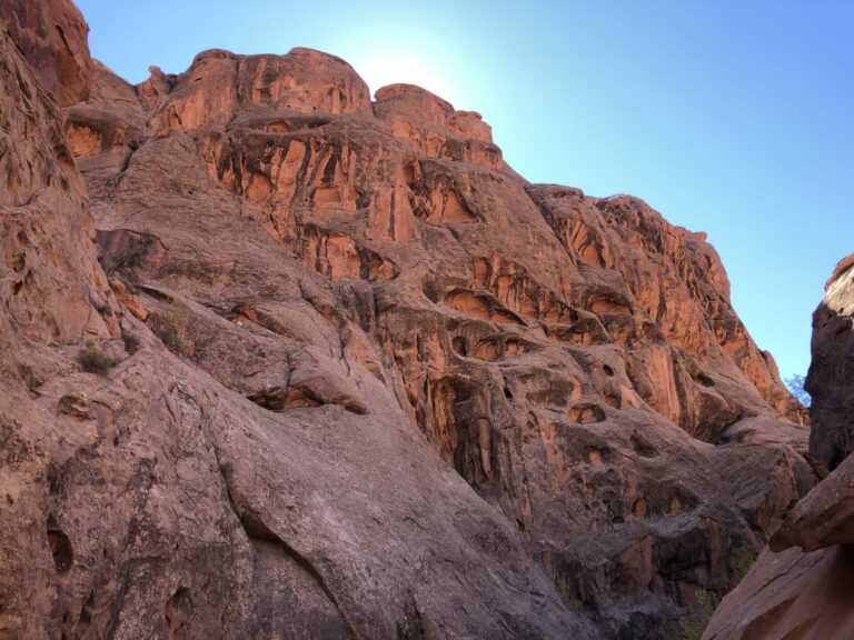
Muley Twist Canyon is remarkable for the varied erosion patterns of the rocks and the different kinds of rock one can see. If that’s not for you, I apologize. I personally cannot get enough of red rock, blue sky and green pine/piñon trees.
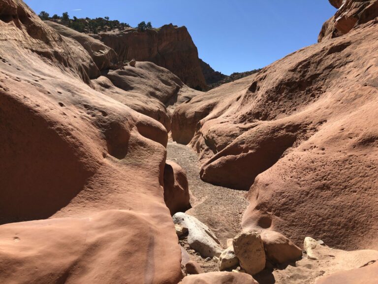
The width of the canyon varies widely along its approximately eight mile course. This is a portion of shallow slot canyon.
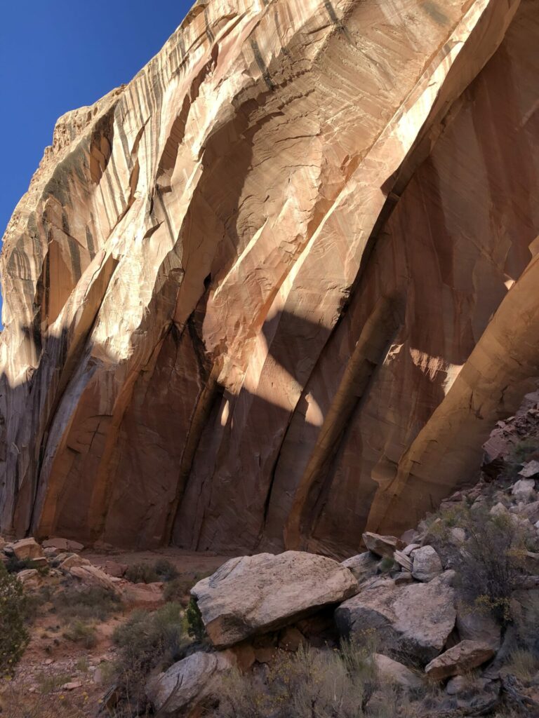
This is another layer of rock being exposed, more yellow in color than the reddish iron-containing stone in the pictures above. Becauset of the curvature one could make oneself believe that this is an arch or bridge in the making. Coming back in a couple of 100k years to see what happened.
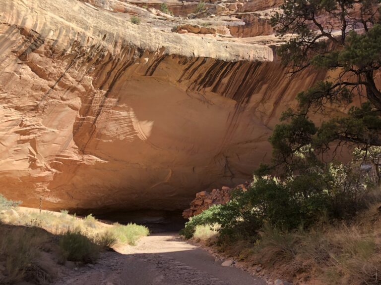
The canyon drains an absolutely huge area. In the summer during monsoon season real torrents must be flowing through here. The undercut shown here, where the canyon makes a turn and the floods hit the wall head-on, is an illustration of the power of the water running through here.
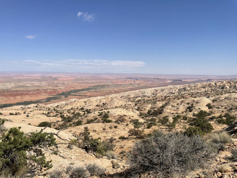
I have left Capitol Reef NP in the direction of Lake Powell, have entered Glen Canyon National Recreation Area and have started to climb up the slick rock/sand slopes to the West. This is a look back into the Hall’s Creek drainage that drains Grand Gulch and many, many side canyons into Lake Powell.
You will notice a green band starting in the middle of the picture at its left margin sloping up and to the right. This area used to be covered by Lake Powell, but has not been for many years and hence vegetation has moved in.
Slightly off-center to the right you see a short “hook” pointing left and “up”. This is a small stretch of Lake Powell. This gives you an idea of how much the lake has been drained in excess of water input from snow melt and summer monsoons. A local told me that it would require on the order of 50 years of above-average snow fall for the water level to rise substantially.
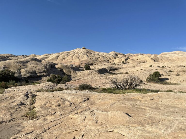
After the look East, now a look West, upslope, as I ascend to the crest. It is a mixture of slickrock and sand that one walks across. There are hidden cliffs on this slope. It is a typical off-trail hike where you have to observe carefully and plan ahead on where you intend to go in five to ten minutes’ time and how you will be connecting your present location to where you want to to be five minutes hence. This is so much fun!
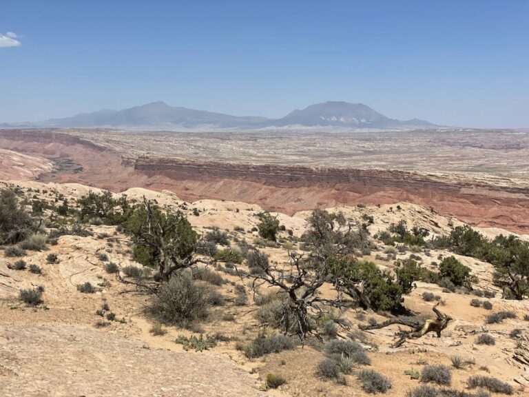
Another look back from near the crest. On the horizon two massive mountain ranges, the Henry Mountains and Mt. Hillers and Mt. homes (I think). In the foreground on the left is the Hall’s Creek drainage. You can see how the creek meanders down the drainage. Wherever you see green, that’s where the water is running. The foliage is part cottonwoods of all sizes, but mostly invasives such as Russian olive and tamarisk, and reed, lots of reed. The vegetation is so thick that it is mostly impenetrable, but there is the occasional game trail that one can use to get out of the drainage onto the slopes away from the water.
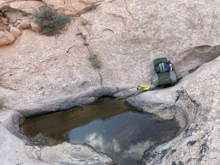
One of or the the greatest challenges of this hike is the supply of water or the lack thereof. As I said in the intro, I had turned around twice before for lack of water. As you climb out of the Hall’s Creek drainage and ascend the slick rock slope there is a kind of belt of potholes where the runoff from rain hitting the slick rock surface collects. As I reached this belt of potholes I still had enough water from Hall’s creek and I did not fill up. Bad mistake! I assumed that there would be potholes higher up as well. Bad assumption based on absolutely nothing!
I reached the crest and was out of water. It was late afternoon and I had about an hour of daylight left. I was not worried, but I was not entirely comfortable with my situation is nice I did not know when I would be finding the first water on the west-facing slope. A thirty minute concentrated search yielded this pothole with cold, clear (for backcountry standards) water, so I had a pool party. I have been hiking in Utah for long enough now that I have an intuition as to where it pays to look for water and where it would be a waste of time. It used to take me a lot longer years ago.
OzarkHillbilly
Please, do.
OzarkHillbilly
Love the pics, and the tales make them even better.
pb3550
Agree totally with Ozark. You’ve opened beautiful land I’d never get to see otherwise.
currants
TKH I love this. Lived in NE AZ for a year (Navajo res.) and like you, I love the colors of the rocks, sky, and piñons–what a feast! Maybe even better than seeing the piñons is the smell of them burning in the winter. It’s so distinctive–yet I don’t even know how to describe it.
Thank you for sharing these!
cope
Again, wonderful pictures of spectacular country. I really resonate with your joy in route finding, one of the great pleasures of going off trail.
Thank you.
eclare
Otherworldly photos, thanks!
SkyBluePink
Thank you for sharing your awesome adventures in picture and word!
mvr
Nice! I take it you still have to filter or otherwise clean the water from the potholes.
Thanks!
Yutsano
You can’t fool me. Those pictures are from Mars!
It’s so remarkable how the plants take up residence in the stark scenery. Life does indeed find a way!
TKH
@mvr: Yup, that pool was full of tadpoles and some kind of worm. So I filter through a sump pump sox to get the crud out and then through a microfiber filter to get bacteria out.
Dmbeaster
That water source is why they call the entire feature in Capitol Reef the Waterpocket Fold, which you know, but others would be new to this.
Hiked Upper Muley Twist this year – a bucket list item for me. Love seeing pictures of the lower portion. The yellowish sandstone is Navajo, and the red is the Kayenta and Wingate (depending on where you are), and Wingate is my favorite sandstone bedding in Capitol Reef
J R in WV
As a recreational geologist (AKA rockhound and mineral collector) from West Virginia, where all the rocks are covered with vegetation, the far west was so amazing when we first traveled out there. Bare geology everywhere you looked… well, not everywhere, but so much more than in the east. Chaco Canyon, Monument Valley, Navajo Nation, Shiprock, all so amazing.
I’m well past being physically able to hike around on our farm, let alone off trail where you have gone, so I’m so grateful for you sharing these photos and stories with us. Wonderful adventure sitting at my laptop.
Thanks so much! And BE CAREFUL out there.
A good friend moved to Montana and travels all over the state to stay in contact with their wide spread organization. Their spouse bought them a Sat Phone for emergency use anywhere, as cell networks don’t cover the big sky states anything like 100%. I hope you also carry such a device out in the back country!
TKH
@J R in WV: Years ago, during a traverse of the Pyrenees, I encountered deep snow on the high passes as a result of a late major snow storm. My foot prints were the only ones apart from those of the goats. I came to the realization that it would probably take another two weeks for me to be found by somebody happening to come by if I had an accident. Returned to the US and right away bought a satellite beacon with which I check in every night with my emergency contact. Whether this would actually work in canyon country in an emergency in a deep canyon I will hopefully not have to find out.
StringOnAStick
@TKH: We always carry a satellite beacon now, they are affordable and small enough that there’s no excuse not to.
Have you checked out the geology around the Henry mountains? It was part of my geology field camp course; the exotic igneous intrusion/injection features between layers of sandstone are quite striking! Laccoliths, etc., with nice big feldspar crystals since it cooled slowly. I’ve never seen anything else like it.
TKH
@StringOnAStick: I have come to realize that I have absolutely no clue about Earth science. I know about the Wegener hypothesis and that’s it. Really too bad! A consequence of a university education in the Germanic tradition, i.e. early specialization and little to no room for a broader general education.
I have spent the last two years, or the parts thereof that I was not in the bush, to learn some virology and immunology. With that done, I intend to learn some geology to better understand what I am looking at when I am out there.
Snarlymon
When I lived in Utah, Capitol Reef was my favorite haunt. I stayed near the campground on my hikes, and still found it to be mind blowing. So many great memories. I wonder if you have ever been to Cathedral Valley? That’s on my bucket list.
StringOnAStick
@TKH: It’s great that its the canyon country calling to you; that’s geology you can actually see because it isn’t covered in a bunch of green stuff!
A used geology 101 textbook would give you a lot of what you are looking for. There is also a series of “Roadside Geology of” paperbacks that are geology at mile markers for various areas, mostly in the west. Your love of the canyon country means you should be able to find basic geology books for those specific areas too. Happy hunting!
I left the field of geology many years ago due to economic downturns, but I still identify as a geologist and I have a great love for all I learned and how it informs my daily life still. Now we live in volcano country, an area of the field that I never worked in so I’m getting a whole new set of lessons.
Dmbeaster
@Snarlymon: Cathedral Valley is absolutely worth it. There is a remote campground at the west end that makes a nice stop. I drove in on the south leg of the loop from the highway and car camped there, and then continued on the north side return of the loop back to the highway, going past all of the spectacular features (the Temples). Various back roads also access Cathedral Valley. The bedding is a softer version of Entrada which gives it a more sculpted rather than jagged look. The Chinle and Moenkopi are spectacular on the eastern end. There is an amazing bentonite deposit as well on the south leg of the loop.
TKH
@Snarlymon: I have driven by many times while caching supplies for my hikes, but I have never stopped and explored the area. One of these days I’ll be spending some time in the Hanksville-Hite corridor and in the Henrys. That would be the right occasion to visit and explore Cathedral Valley.
Chris T.
@StringOnAStick: Yeah, the Henries (Henrys?) are amazing. That whole part of Utah/Arizona is something. Harsh country though, with the dry air and the 50-degree-F daily swings in temperature…