On the Road is a weekday feature spotlighting reader photo submissions.
From the exotic to the familiar, whether you’re traveling or in your own backyard, we would love to see the world through your eyes.
cope
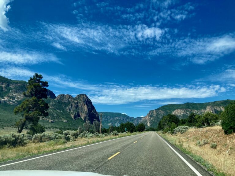
Our next day trip was one I’ve done multiple times but never tire of. From south of Grand Junction, we drove into and up Unaweep Canyon to the small hamlet of Gateway. From Gateway, we drove John Brown Canyon Road west out of town and out of Colorado into Utah and the La Sal Mountains. My other sister drove while her husband, my grandson and I rubbernecked the whole way. We did a loop drive and came back by way of Castle Valley and, eventually, I-70 back to GJ.
Unaweep Canyon is fairly unique in that there is a watershed halfway through it. A watershed is a topographic boundary at which water flows into one drainage basin on one side and a different drainage basin on the other. Think the Continental Divide. The canyon itself is very dramatic with high vertical walls and hundreds of feet of sediment filling the valley floor. The origin of the canyon is not settled though the most accepted interpretation is that it was carved as an ancient pathway of the Gunnison River.
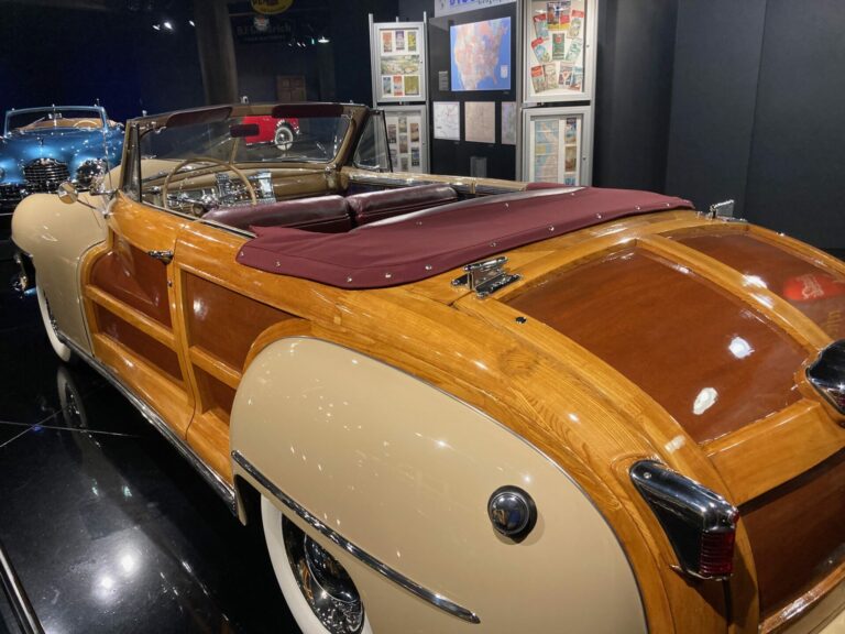
Much of the land around Gateway was bought up by the founder of The Discovery Channel. He built a swanky resort and some fancy homes and opened a museum for his collection of American cars. Who could resist? This is one of the sparkly, shiny vehicles, just don’t ask me what make or model. That body trim is real wood.
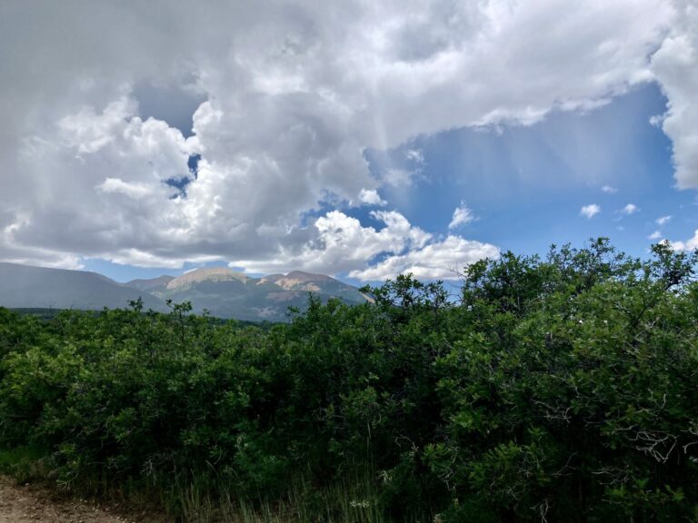
John Brown Canyon road is unpaved and goes up and over a 9,000 foot pass into Utah and the La Sal Mountains. Here are the mountains, off in the distance. You can judge their height by the fact that in this part of the world, tree line is at 11,500 feet, give or take. On our way, we hit a bit of rain, visible ahead on the left. Also visible is an example of virga. Virga is rain that falls from a cloud but evaporates before hitting the ground. Those gauzy streaks below the clouds on the right are virga.
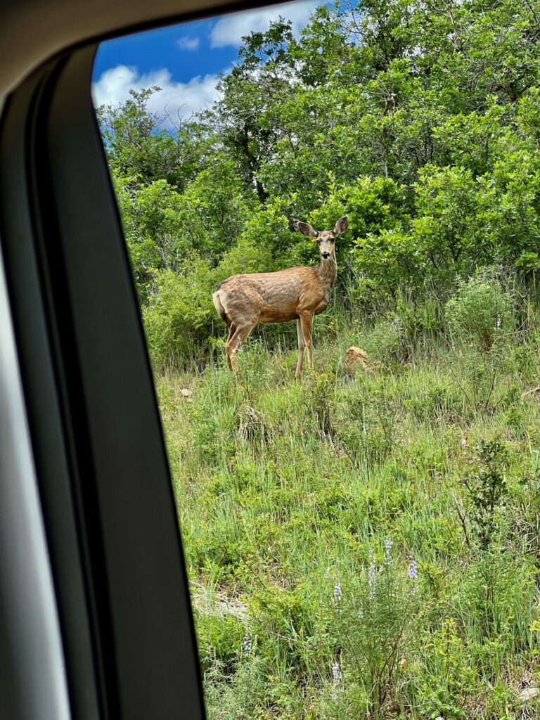
Driving slowly, we passed a couple of deer. This being July, they did not seem too spooked by us though I suspect come September, they would likely not be seen anywhere close to the road.
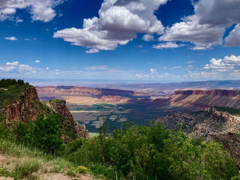
Now into Utah (my sister’s nav system unexpectedly said “Welcome to Utah” when we crossed the state line), we could look down into Castle Valley. Castle Creek flows down the valley into the Colorado River. The distant most visible landforms are The Book Cliffs. With one end of The Book Cliffs at Grand Junction, they march about 200 miles off into eastern Utah. When I was an oilfield geologist, I had the great fortune to sit a well in the mouth of Castle Valley.
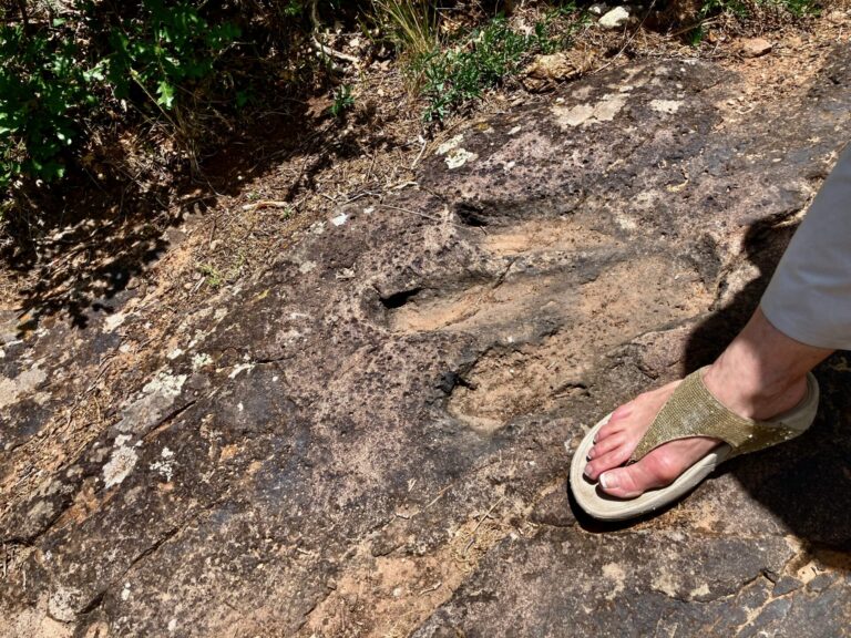
Near the top, we got out at the Bull Canyon Dinosaur Tracks Overlook. I had never been there and was quite surprised at how undeveloped it is. The top layer of the Jurassic age sandstone has dozens and dozens of dinosaur footprints belonging to different species of different sizes. There are no prohibitions about where you can walk which I found somewhat unique.
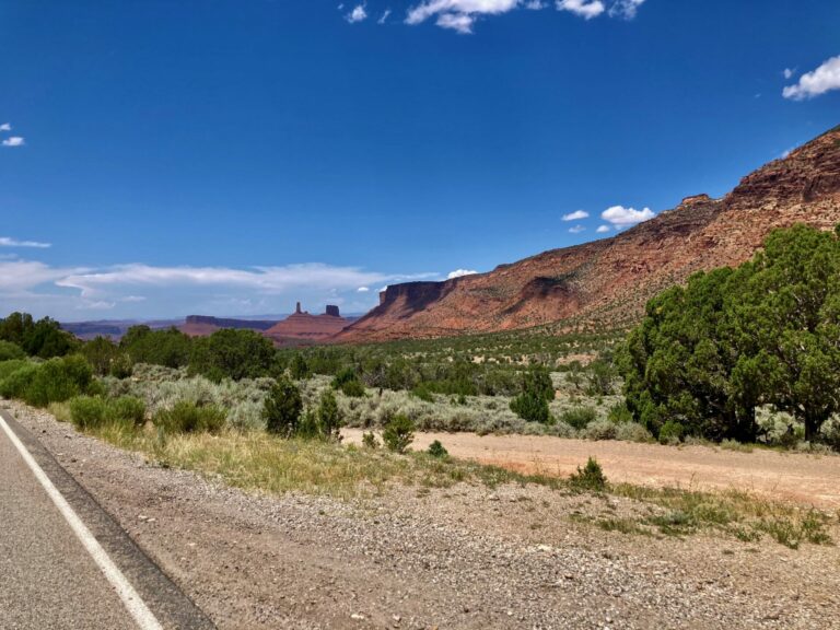
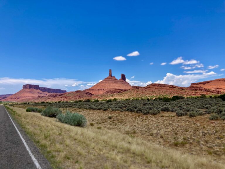
Dropping down into Castle Valley, we began a gentle descent toward the Colorado River. The distant spire is Castleton Tower and the formation to the immediate right of it is called The Priests and Nuns. We were back on paved highway at this point and starting to get hungry.
Castle Valley is quite large and not formed in the classic way by running water but rather, it is the result of the collapse of an ancient salt dome caused when ground water dissolved away much of the salt deposit beneath and the rock layers above slowly collapsed to form the valley.
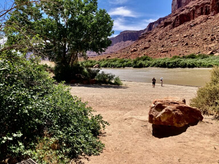
A bit upstream from where Castle Creek empties into the Colorado is Hittle Bottom Campground. It is a favorite put in/pull out site for rafters and our chosen destination for lunch. At this time in July, the river is pretty low and flowing fairly slowly. The foreground boulder, though, is testament to how high and fast the river can get at times.
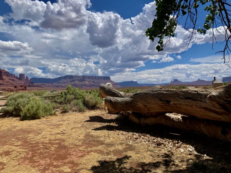
In this view from HIttle Bottom, you can see Castleton Tower and the Nuns and Priests above the cottonwood log on the right. Fisher Towers sit on the skyline toward the left. Castleton Tower gained national notice when a 1964 Chevrolet Impala Convertible was choppered to the top of it in pieces (minus the heavy bits) and reassembled for a TV commercial. Supposedly, at one point, the plucky actress and several crew were stranded on top when winds prevented helicopter extraction.
We stopped to look at some petroglyphs on the way home but some total fucking assholes have added their initials and dates to the rock face in “modern” times and it’s just too depressing to look at.
Still to come, a visit to a unique location for thrill rides, Glenwood Caverns Adventure Park followed by a trip up to The Potholes, a flash flood, and a raft trip down the Colorado River.
Baud
The dinosaur footprint is too cool.
Amir Khalid
Hmm. So how did people protect their car’s exterior woodwork from the elements?
OzarkHillbilly
I gotta get back to the southwest.
Albatrossity
Wonderful pics and stories. Now I have several places to explore the next time I get out to the GJ area!
JPL
Although I’m not a car person, I do admire that car. It needs a sign that says hop on in.
Benw
Amazing pics and a really cool drive. Inspiring!
rekoob
For what it’s worth, the car is a circa-1947 Chrysler Town & Country Convertible at the Gateway Auto Museum.
First Generation (Post-War) T&C
Wag
Cars have always been a defining feature of the area around Moab. Here’s the amazing ad from 1964.
https://m.youtube.com/watch?v=I8YpCTuKLec
citizen dave
Great pictures and captions! For those interested, here is that 1964 Impala commercial:
Link
Bizarre indeed. I can see why the Mad Men series was made–you can practically hear those guys coming up with this idea. I guess we’re all supposed to think “How did they get that car up there?” instead of, say today, we’re like “WHY did they put a car up there?”
The funniest part to me is the car is so very very plain looking
ETA: Wag beat me by a minute! Great minds…same thought, etc.
WaterGirl
@citizen dave: I edited your comment because the long link was breaking the margins on phones.
Yutsano
You had me at the dino feets…
mvr
Especially like the last image. Thanks!
StringOnAStick
We did a 7 day mountain bike ride from Telluride using the San Juan Mountain Hut system 10 years ago, one night stopping in Gateway (and begging a reduced rate late room at that fancy hotel when the hut was still an oven at 10pm. The next day we rode up that John Brown canyon road, one of the hardest things I had ever done, until two days later when we rode out of Paradox up the highway to get to our last hut in the La Sal mountains. 43 miles, 8,000′ of elevation because our designated route to that hut was blocked by a small forest fire and the response to it.
It was quite the trip. The scenery was amazing!
cope
@StringOnAStick: That must have been a heck of a trip in multiple ways. I’m too old and my knees too game for that now but I can imagine.
J R in WV
When touring decorated caves in SW France and NE Spain some years ago, we saw lots of 30,000 odd year old art, one “page” of which had also the name and date of a Frenchman in the mid 1600s. The only such example I recall. Old enough to not be despicable seeming, tho.
The car with the classy wood body work may be a Chrysler? Pretty sweet example of the woody style. I think most popular on the west coast, where frequent wax work could be sufficient to protect the woodwork.
Dinosaur footprints you can walk on — classic western geology, love it.
StringOnAStick
@cope: I’m turning 65 this year and while my new knees have me skiing and hiking more than ever, I don’t think I could do either of the 7 day Sam Juan Mt Huts trips again. Well, I probably could but I’ve done both of their two 7 day routes and while they were a great experience, I’m not sure I could talk myself into doing it again. There’s lots of other things to do and go see that I haven’t done yet, so they are higher in the list.
Thanks for bringing some D votes back to the Grand Valley! Escalante canyon is interesting too, just do it in the spring or fall. Also the dirt road that runs from up our of Unaweep canyon and into the Uncompahgre plateau (another interesting uplift) is an excellent day trip too. There are great vistas from the edge, far views into UT and South to Norwood.
cope
I’m still on my original 72 year-old knees. I should maybe have traded them in a decade or so ago but I didn’t.
We’re familiar with Escalante and Dominguez canyons from when we lived here in the ’70s. Also, the gravel road up out of Unaweep that I know leads up to the top and BLM land where we used to go cut down a tree every Christmas.
There is absolutely no shortage of accessible, wondrous places even my old tired limbs can drag me. I can’t wait to visit some old favorites.