On the Road is a weekday feature spotlighting reader photo submissions.
From the exotic to the familiar, whether you’re traveling or in your own backyard, we would love to see the world through your eyes.
I’m not brave enough to climb mountains, so these vicarious mountain climbing trips are the next best thing! Amazing.
Remember, you can always do a 2-part On The Road, and I’ll plan to run them either back-to-back or early morning and then After Dark.
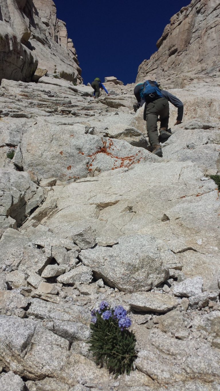
Its crazy to edit it down to eight pictures, but here it is. I introduced my nephew to mountaineering climbing Mt. Sill (Norh Col route – class 4) in the Palisades located in the Sierra Nevada. Five years ago, he and I led 5 others up Whitney on the Mountaineer’s Route, which was pioneered by John Muir climbing solo. The five were my two adult children, my nephew’s wife, and a couple that were friends of my daughter. The first two days were modest backpacking days to get to Iceberg Lake at 12,600, which reduces the climbing day to 1900 feet. The route used to be cross-country, but so many have stomped it that there is now a well worn use trail. The route is class 2-3 mostly, with a few spots that are class 3 for a few feet.
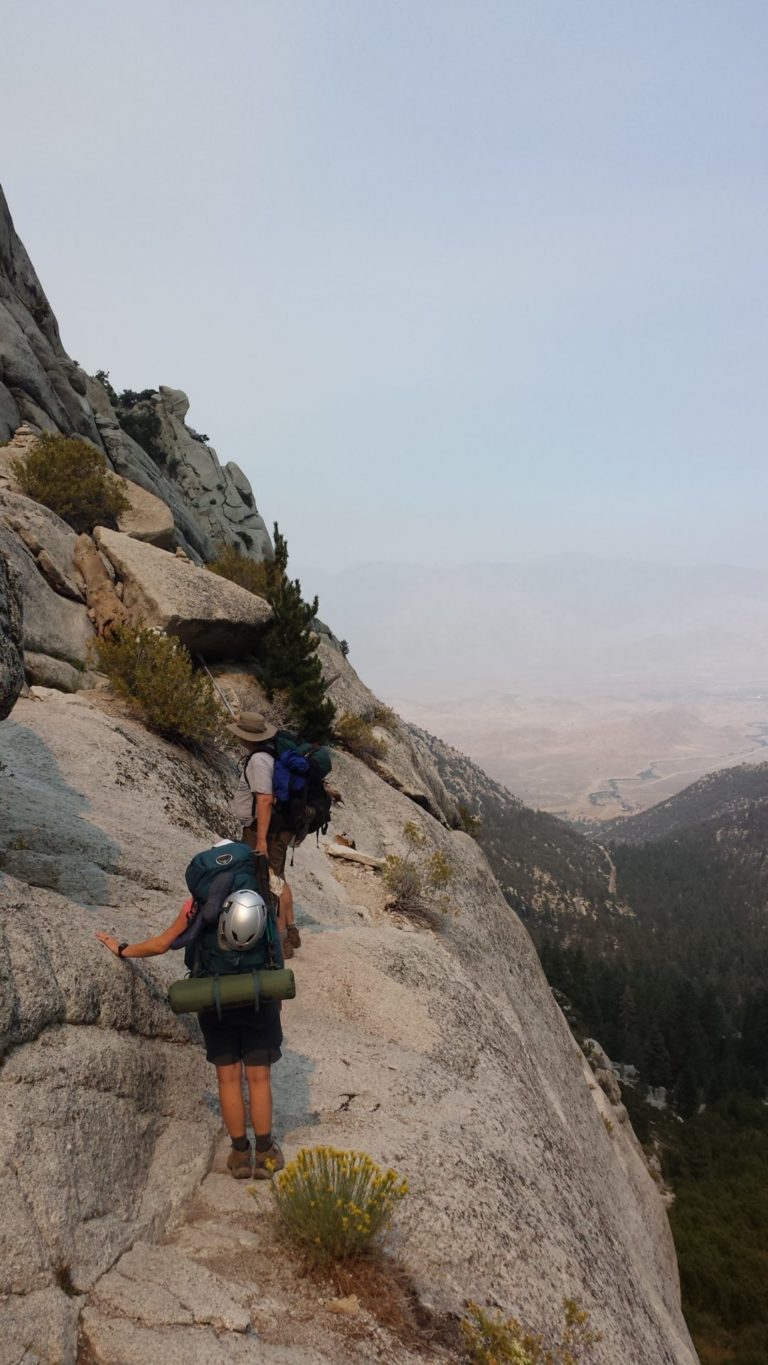
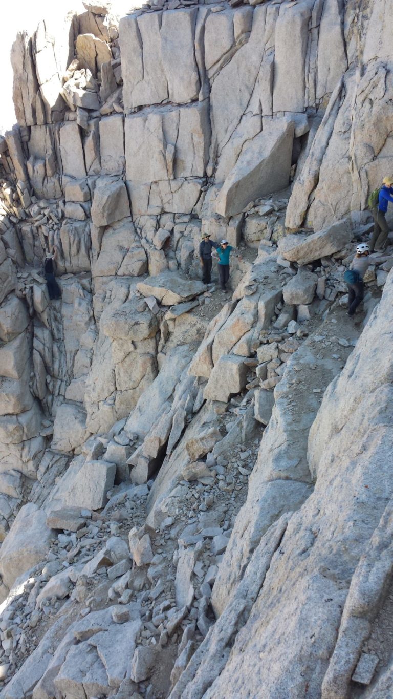
Ebensbacher Ledges which are famous on day one. I forewarned everyone that this was not going to be your typical trail hike. The wall is precipitous, but easily climbed on decently wide traversing ledges. I am in the front pointing the way with my pole.
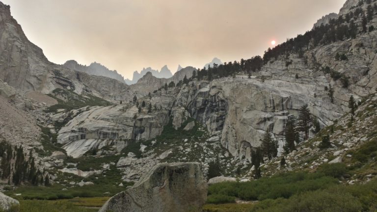
Little Boy Scout Lake, end of first day. There was a major forest fire on the west side of the Sierra creating color and a smudged sky (that is the Sun in the picture), but which largely cleared the rest of the trip. Whitney is visible peaking over the foreground ridge on the right, and the other pinnacles are various needles of Whitney (Keeler, etc).
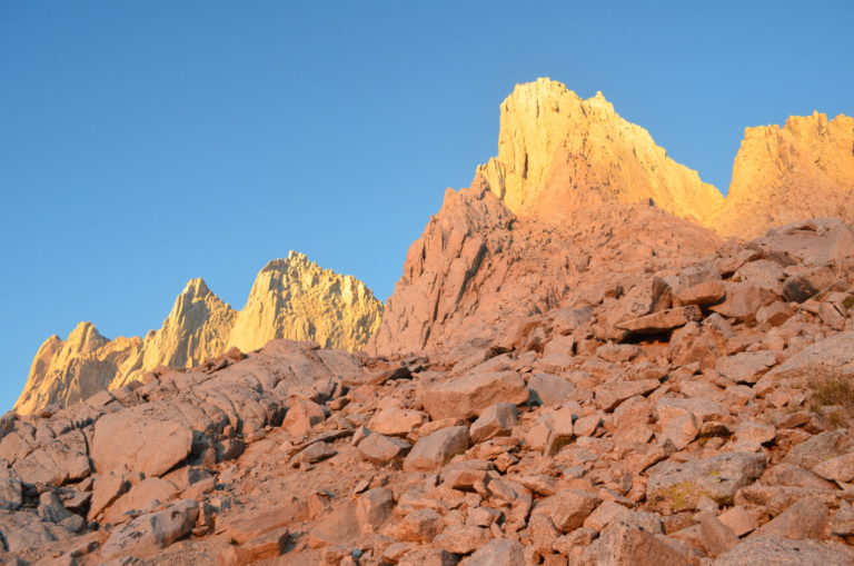
Beginning of the climb on the third day – I have gone about half a mile and climbed a few hundred feet. I start earlier than the younger set, so I am solo until they catch up (they will). The alpenglow on the east face of the Whitney peaks is magnificent — there is nothing blocking light shining a vast distance through the atmosphere from the far eastern horizon. I have countless pictures of the alpenglow showing it in the various stages in many places in the Sierra, but this is the highest and largest unobstructed big wall in the Sierra for dawn alpenglow.
The first light, and the rocks are grey. Then as the very first rays start to get a line of sight, the color is a soft rose mauve color — faint. Then it starts to transition to red-orange to orange and gets brighter. Then it transitions to a yellow color and is brighter still, which is the last color phase. This picture is the transition between the orange to yellow, as the earlier color moves down from the top and is replaced by the next phase.
Whitney is the high point on the right, and the route heads up to and through that deep notch to the right of Whitney. The notch is 14,000 feet, or around 1,000 to 1,200 feet higher than this vantage point. The peak is 14,500, although for years it has had a number of figures around that. The last 500 vertical feet, you climb just past the notch, and turn hard left to go up a very steep broken slope that is out of view. The top of the mountain is surprising huge and flat.
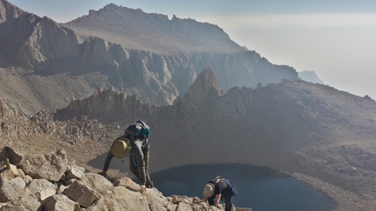
Half way up the chute to the notch — my nephew took this shot as I was still ahead of them. That is my daughter’s friend followed by my son. Below is Iceberg Lake where we camped – at 12.600, it is well above timberline. In the background are the eastern ridge line that leads to Mt. Russell, which is out of view to the left. In the far background throught the left over smoky haze, you can make out the faint image on the Inyos that are across Owens Valley to the east, and reach 11,000 in height. I have spent a lot of time in that range fossil hunting, and also visiting Saline Hot Springs in Death Valley National Park which is immediately on the other side.
Most of the way up the chute to the notch. This is probably at 13,700, and that foreground flower is polemonium (also known as sky pilot). There are a lot of species of this type of flower, but this particular one only grows in the Sierra at very high elevation on talus slopes. You pretty much have to climb mountains to find this flower, and there was a lot of it.
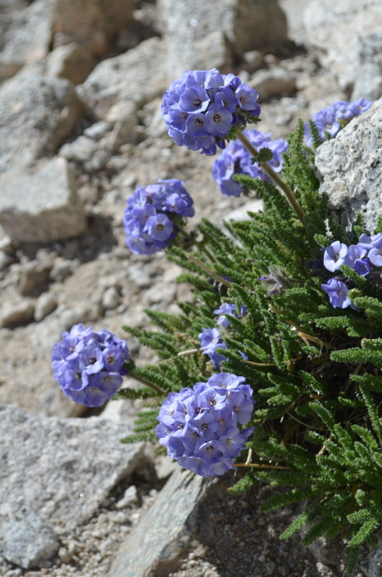
Closer polemonium shot. I have lots more because I live for wildflowers. California has no end of them in wildly diverse landscapes.
Now past the notch and in the steep broken slope just below the summit. This is probably at 14,300. My nephew and I are together where this picture was taken, and from right to left, it is my daughter, my nephew’s wife, my daughter’s friends, and my son taking a wild line on the far left.
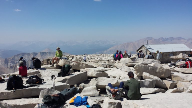
The summit, which is usually something of a party with a ton of people on top. This is looking slightly southwest. The hut was built in 1909 by the Smithsonian for astronomy observation. Our approach crested onto the summit plateau about 200 yards to the right, and we go back down the same way. The traditional trail approach ascends the gradual western slope, and you can see tiny people on the foreground horizon making the last 1/4 mile on an 11 mile 6,600 gain from Whitney Portal.
The rugged range directly over the hut are the Kaweahs, which are famously remote and rugged (and also crap volcanic rock like the Minarets in the Ritter Range further north — a “roof pendant” of much older rock than the Sierran granite. The pendants are remnant pieces of the older rocks into which Sierran granite intruded from 80 to 140 million years ago when everything visible was then several miles beneath the surface, with the granite being formed as the ancestral Farallon oceanic plate subducted under western North America) . The peaks further left and further out are the southern extension of the Great Western Divide. Mineral King is directly on the opposite side of that subrange in that view. Most of what you are looking at is the remote backcountry of Sequoia National Park. I have other pictures with the views in other directions, which are obviously panoramic.
This is an easy mountaineering trip, but one of the most satisfying as it is one of the very few times I climbed with both of my children. Afterwards, my daughter told me that the Whitney climb was one of the coolest things she ever did. Now that is a nice memory.
David Evans
Those are impressively good pictures. I love the sky pilot.
p.a.
Wow. Tks!
low-tech cyclist
That first photo is absolutely stunning, but just looking at it and thinking of hiking that path gives me vertigo. I can just feel that void trying to suck me in.
JPL
The pictures are amazing and although beautiful, not a trip that I’d add to my bucket list.
J R in WV
Amazing hike, no question!
Thanks for sharing the photos, and as Watergirl says, don’t hesitate to submit more photos anytime. Looks like she will be doing two a day for the foreseeable future, which I think it great. Fossil hunting while mountain climbing… so cool. I’ve hunted for crystal minerals up high in Colorado, above the tree line, but we cheated, and drove up in a small PU truck on an old mining road. Found a little smokey quartz I still have somewhere in all the rocks.
OzarkHillbilly
Going up is easy. Now getting back down… ;-)
gkoutnik
What a gift you have given your kids (and us, for that matter). Awesome.
And – I’m with you, OH – these knees would much rather go up than down.
debbie
Beautiful and scary at the same time. Thanks for sharing these! (And persist, sky pilot, persist!)
raven
About 25 years ago my buddy and I went up to Triple Divide Peak, about 15 miles from Whitney but a 10 hr drive!. It was July and we saw exactly 2 people in three days. It wasn’t an especially technical climb but Ozark is right, coming down was a bitch!
Wag
Great phots! Looks like my kind of hike. It reminds me of Longs Peak here in Colorado, which after a long class 3 album at the end, suddenly flattens out to a flat 4 acre summit.
arrieve
Even on stairs I’d much rather go up than down, and I will never be climbing mountains, but I’m very glad to have the experience vicariously. Great pictures!
sherparick
Thanks for the great pictures. I love mountains. Once you get plate tectonics and mountain building in your head that actually appear to be moving as they thrust up from the Earth, whether the Sierra or the Alps.
Meyerman
Thanks for sharing the trip. I’ve been on Mt. Kaweah looking at Whitney and now I know what it looks like from the other direction. What kind of permits did you need for camping and the summit hike?
Kosh III
Great pics and hike but NO WAY would I do that even if I were young and fit instead of old and mostly fit. Just looking at that first pic made me dizzy.
frosty
@low-tech cyclist: I’m with you there. The vertigo seems to get more pronounced every year. I hate hate hate any place with edges and dropoffs. Great pictures but hard pass on the climb.
ETA Now, a nice walk through high-country meadows with llamas carrying my stuff? I’d get in shape to do that!
frosty
@raven: You seem to have a picture for everything! Congratulations on taking them, saving them, and scanning them.
WaterGirl
@frosty: If you want pictures, music, great stories, raven’s your man!
Raven
@frosty: I was lucky to have been among artists!
have you tried this vertigo exercise?
https://youtu.be/mQR6b7CAiqk
Raven
I’m sitting in the car at the Atlanta Sewing Center! We decided to do Costco and it was only a few miles further so she’s looking at thread!!!
WaterGirl
When I mentioned two-part On the Road submissions, I meant that for everyone for any submissions that seem impossible to get down to 8 photos while still conveying the essence of the trip. Not just for dumb Easter. (Ha! Is that the autocorrect that everyone gets for dmbeaster?)
frosty
@Raven: I was unlucky enough to go through a too-hip “photography isn’t cool, I’ll just remember everything” period in my 20s and early 30s.
The only saving grace was that I kept a journal during my Walkabout Year – Railpassing through Europe and two laps of the US. And to be fair, the camera was too big to keep on my person 100% of the time to be safe in the hostels where I was staying.
StringOnAStick
Oh, lovely! My +14,000′ peak experience is all in CO, but removing farther West next spring so Whitney is on the list now. I too live for wildflowers, especially alpine varieties like skypilot. My favorite is alpine sunflower, a big (for alpine flowers) bloom on a tiny plant; they just hit their peak 3 weeks ago here. We saw lots of it and skypilot when we rode bikes up Mount Evan’s 2 weeks ago.
eclare
Great pictures, thank you! I couldn’t take the altitude, so thanks for letting me live vicariously!
JustRuss
I hiked up Whitney on a whim with some friends after finishing high school. My 17-year-old lungs struggled a bit at 14,000 feet, not sure how they’d do 40 years later. Still, that route looks like a lot of fun. Marvelous pics.
opiejeanne
Thank you for this gorgeous set of photos. I’ve never had the nerve to climb that way, so like the lady said, this is a nice vicarious adventure.
@OzarkHillbilly: My stomach flipped when I read that.
My husband took the traditional path to the top of Mount Whitney when he was 21, (1968) before we met. He and a buddy had screaming headaches the first day so they camped a little early. They had trained and worked out for weeks before and were in great shape, but the elevation got them. Their other buddy drank beer and watched them work out, and he had no problem with the elevation. From their campsite they watched an older woman with her little granddaughter, about 8 or 9, pass them on the way to the top.
I hiked and fished a lot when I was younger, and the toughest one I did was to Lake Agnew in the eastern Sierras, because I’m a creampuff. It’s only at 8500′ and the trail starts at about 7500′, and there is a trail but it’s all steep switchbacks on large, sharp rocks. It was just a day hike and we spent that night back in our cabin, sunburnt and sore and a little frustrated that the nice big brown trout, plural, that we could see in that lake could also see us.
Our supper that night was by reservation at the Carson Peak Inn, and while we waited for our table to be ready a couple of young women rushed in, out of breath and excited. They had been camping and decided to eat out, and let the bear have their trout supper.
In the same region of the eastern Sierras, we’ve hiked to Little Walker Lake and Parker Lake, one of which is a very scenic hike, part of it through a large meadow filled with wildflowers, crossing swift streams on huge logs, and the other hike is rugged with little payoff, and we could never remember which was which. The less attractive hike had a breathtaking view of Mono Lake, on the way back, and the lake itself was dark and deep, with no shore to speak of. Kind of a scary place and we didn’t catch any fish. You could fall from either path in the steep and narrow places, and you’d probably die so we tried not to think about that
I can’t believe I did all of that in tennis shoes.
pat
@low-tech cyclist:
My thoughts exactly.
But thank you so much for the photos and the geology lesson!
?BillinGlendaleCA
Great pics and I ain’t climbing that route, or pretty much any route at my age. I’ve seen the sunrise at Mt. Whitney(from the safety of the Alabama Hills about a week ago) and it is exactly as dmbeaster describes.
Dmbeaster
@Meyerman: The route only requires a standard wilderness permit, with a daily quota of 8 advance reservations on a first come basis, plus 4 more on a walk in basis. The main trail route is swamped with requests, and has a special lottery for permit requests. But the mountaineer’s route avoids that headache. You can camp anywhere and there is no separate restrictions or permits, except common sense rules about being too close to lakes and streams.
BigJimSlade
Great shots! Regarding the height, when I went up in, um, I think it was ’78 (I was 11, we took several days to do the whole thing on the regular trail, not the mountaineer’s route), it was 14,495, so when I stood on top, my head popped into the 14,500 range.
Interstadial
What a pleasure to see photos of a route I’d only read about. It’s great to see the sky pilot again and see the morning alpenglow.
I climbed Whitney via trail decades ago, starting from Cottonwood Creek to the south and swinging around to the west side of the crest before going up.
Kelly
Nice to see what the summit looks like. First week of September 1997 at the end of three weeks following the John Muir Trail from Yosemite Valley I woke up to a couple inches of snow at Guitar Lake. Four inches of snow, near white out conditions and then distressingly close thunder at the junction to the summit. Abandoning the idea of completing the last bit of the official JMT route I fled down the east side to a warm, dry motel room in Lone Pine. Until that last day the trip was in perfect summer weather so I’m not complaining.
A woman from anywhere (formerly Mohagan)
Absolutely amazing photos and I cannot imagine doing those climbs. Especially the first picture, but basically all of them I’m thinking “no fucking way” would I (and at this stage in my life, could I) do those climbs. Thanks for the vicarious thrills.
The pictures of the wildflowers were great, and more, please!