On the Road is a weekday feature spotlighting reader photo submissions.
From the exotic to the familiar, whether you’re traveling or in your own backyard, we would love to see the world through your eyes.
Happy Monday! We have a 5-part series from cope this week, so Albatrossity gets a day off.
This is actually a 6-part series, but I goofed up the scheduling and somehow posted Part I in December without realizing it was part of a series. oops! Anyway, if you click on Grand Junction in the category list that’s just under the title, you can refresh your memory on the first post. :-)
cope
The day after our drive up and over Grand Mesa, my grandson and I joined one of my sisters and her hubby for a hike to Devil’s Kitchen in the Colorado National Monument or “The Monument” as the locals call it. The day after that, one of my brothers drove us around the Rim Rock Drive on The Monument. Enjoy, I know I did.
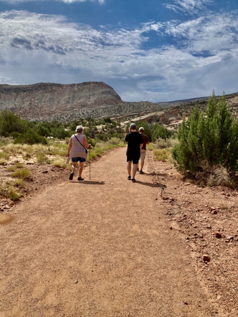
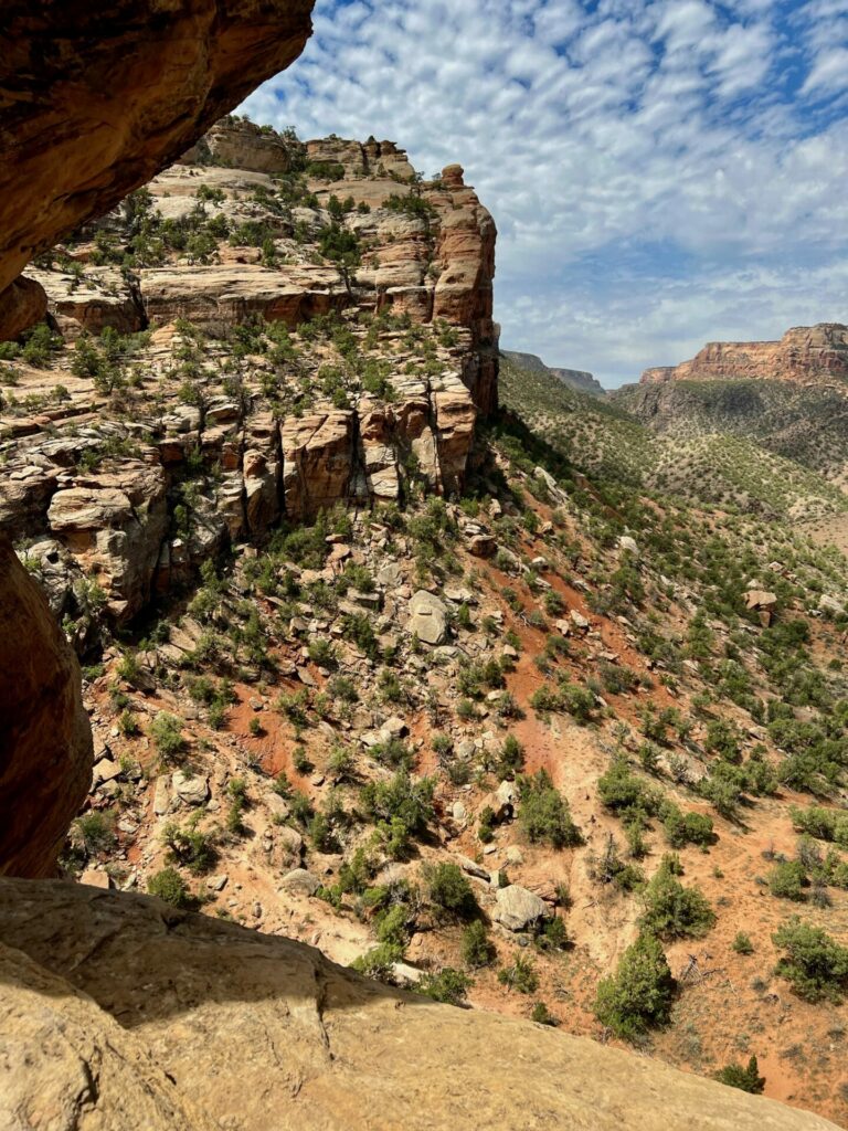
The Devil’s Kitchen Trail at the southern end of The Colorado National Monument sits in the bottom of No Thoroughfare Canyon and is a relatively easy hike of less than two miles with some short, steep switchbacks. As was true during the entire hike, my sister, her husband and my grandson got out ahead of me quickly. You can see from the shadows that we got off to a late start on this clear July day. The trail bends to the right, up toward tilted rocks.
After using one of my sister’s, I am now an advocate for walking sticks on dodgy ground.
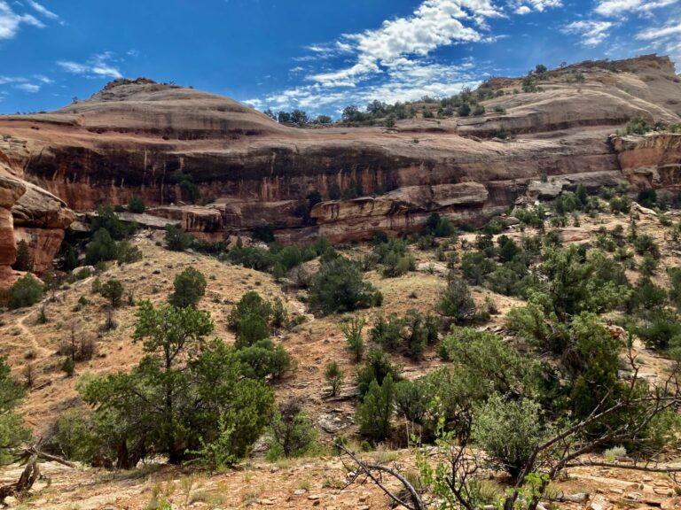
The trail quickly works its way up from the flats. Stained sandstone cliffs of Jurassic Wingate Sandstone flank the canyon. Sitting in the northeastern region of the massive Colorado Plateau, the Colorado National Monument is a more subdued expression of the margins of the plateau, less dramatic than the areas shared with us by TKH but a beautiful place on its own.
Semi-desert flora here include abundant pinyon pine and juniper, rabbitbrush and big sagebrush, broom snakewood and Utah serviceberry.
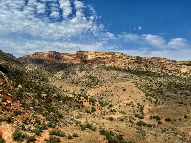
This view toward the north shows the dip of Wingate Sandstone off toward the right. Up this canyon, on the left, you can make out much darker, harder rocks of Precambrian age in the canyon’s bottom. The boundary between the different rock types is marked by a line of greater plant growth where water percolating down through the more porous, permeable Paleozoic sedimentary rocks is stopped by the non-porous igneous Precambrian.
Some economic success was found back in the day mining the Precambrian rocks for mica and quartz but the mines are now abandoned.
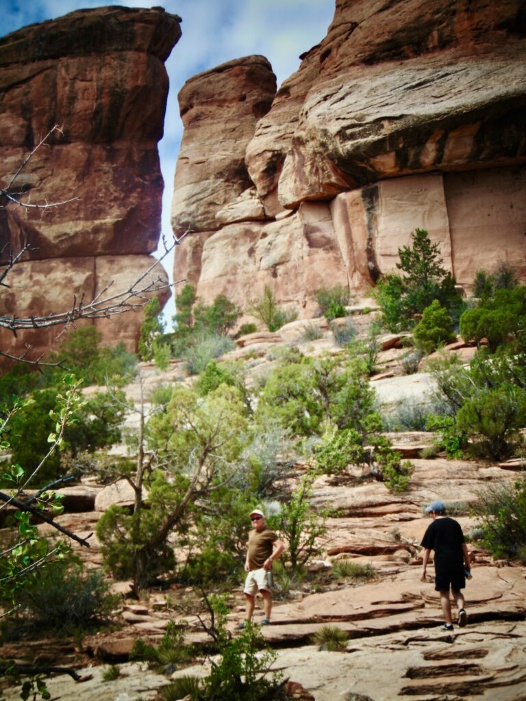
This is just below Devil’s Kitchen proper, located at the foot of the stone pillars above. This entire trail is pretty exposed to the Sun as most of the juniper and pinyon pine are too small to throw much shade. Spearheaded by the efforts of one man, John Otto, the Colorado National Monument was created in 1911. Much of the work creating trails in the monument was done by CCC workers in the depression. At this point on the trail, steps were actually cut into the bedrock.
My family moved to Grand Junction in the early ‘70s while I was still in college and grad school in Illinois. Whenever I went out to visit, this was one of my go-to places to do some rock climbing and rappelling.
This is pretty much the same view as #3 but taken from higher up. Ken Burns, among many others, has lobbied for inclusion of The Monument on the roster of national parks. However, The Monument doesn’t care. It offers lots and asks little and is marvelously accessible to almost everybody, no matter what we call it.
The house we are moving to has views of The Monument to the west and The Book Cliffs to the east and is a 10 minute drive from the south entrance. We can’t wait.
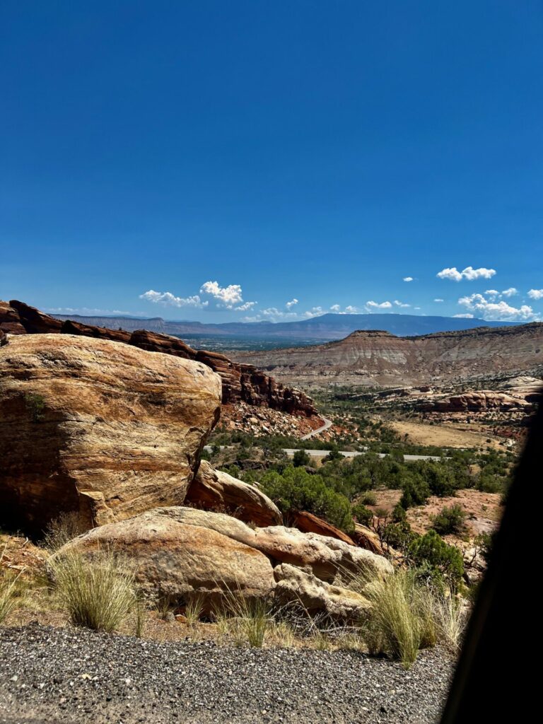
Rim Rock Drive is a 23 mile scenic road that skirts along the cliffs on the eastern edge of The Monument. None of my pictures capture the dramatic views very well but this will give you a taste. One of my brothers was driving and I was shooting out the window. This is right at the beginning of the road as accessed by the park’s southern entrance. You can see Wingate Sandstone dipping away to the east with Grand Mesa on the right hand horizon and The Book Cliffs on the left.
In the large boulder on the left, you can see the characteristic cross-bedding of the sand grains that make up this formation. Cross-bedding results from moving water or wind depositing sediment grains in dunes or sand bars.
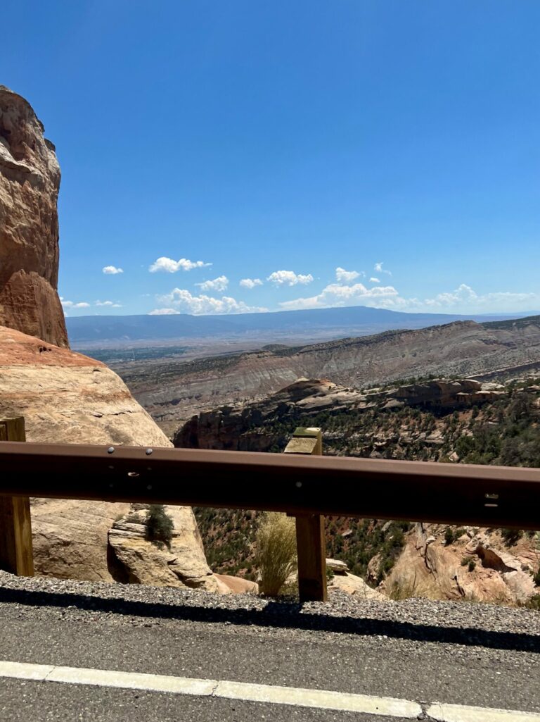
At this point, the cliff drop off about 200 vertical feet just over the guard rail. This picture doesn’t really capture that but it is about here that I realized my life-long attraction to heights had given way to a very visceral fear. Strange. The ever present Grand Mesa looms in the background.
In the ‘80s, The Coors International Bicycle Classic included a stage of the race up The Monument and around Rim Rock Drive. Though the race is no more, Grand Junction has developed itself into a world-class destination for serious bike riders.
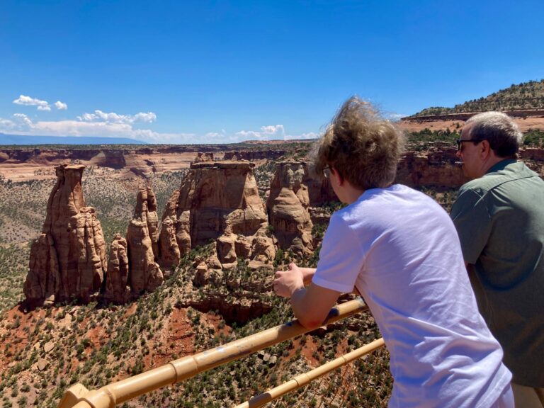
There are multiple pull-outs and trail heads from Rim Rock Drive. This is one of them. A short walk down some slick rock brings you to this overlook of some of The Monument’s characteristic rock formations. The spire on the far left is known as the Kissing Couple, a comparison more obvious from other view points. Moving to the right of the Couple are The Praying Hands, The Needle’s Eye and The Pipe Organ. I’ll let you sort out which is which.
The northern entrance to Rim Rock Drive has a very nice little visitor’s center with an excellent non-cheesy video that runs on a loop all day and tells a concise story of the park, geologically and historically.
Part III will see us driving back roads up out of Colorado into Utah’s LaSalle Mountains and down through Castle Valley to the Colorado River.
Baud
I would love to go on a long road tour of the noncoastal western US. It’s sad that the beauty isn’t matched by the politics of those areas.
eclare
Beautiful! And walking sticks are always good. They give you three points of contact.
Wag
Nice photos the Monument is an overlooked gem the campground is perched on the edge of the canyon, and is my second favorite NPS campground after Arches NP Otto had an eye for beauty
@Baud: Agreed. GJ is Boebert central
Wag
@eclare: I use them in pairs. Interesting study looking at the use of hiking poles showed that they increase speed and decrease perceived exertion while increasing calories burned by 15%
Cheryl from Maryland
Beautiful area. I was near Grand Junction in Fruita about 6 years ago setting up an exhibition on a Giant Snake Fossil (mid to late Paleocene). The fossil was found in a very arid area of Columbia — which was a lush wetland during the Paleocene. The scientists hypothesized that the giantism of the fossils (giant turtles, crocodilians, and fish were also found) was due to a hot climate with plenty of food, thus increasing size. When I asked the staff in Fruita if the exhibition text, which included this warming information, would be controversial, they laughed NOT! My, times have changed.
Albatrossity
I love the Grand Junction region; these are gorgeous pics of a gorgeous place!
And when WaterGirl told me that I had the day off and could sleep in, I sent her this. Thanks for the extra forty winks!
Kevin
It was on my “to visit” list already, I think it just bumped up a few notches. Great pictures.
mvr
Nice!
Thanks for the views!
cope
@Baud: I’m happy to have Boebert as my rep versus having DeSantis and his goon squad running the entire state any day.
J R in WV
We drove around there from the Utah side, Wife and I visited Dinosaur National Monument, Fossil Butte Nat. Mon. Grand Teton and Jackson Hole, and Yellowstone. Flew into Salt Lake and rented a Lincoln, which got nearly 30 MPG on the long tour. Was a great vacay.
Lots of fossils, at Dinosaur National Monument you walked up a ramp and into a building over a famous quarry where Dinos were excavated for decades, until helicopters made it practical to excavate deep in the badlands. Hundreds of Dino fossils embedded in a rock face, giant skull looking out at you. Amazing.
Dunno if it’s still there, I went back by years later and it was closed for asbestos abatement, which may or may not have ever happened… hope it is now open again. OK, web site looks like the quarry is now open, if the snow isn’t 20 feet deep. As we drove across the Uintas Mtns, Wife asked “What are those orange poles beside the road?” They were like 15 feet tall orange plastic poles attached to the guardrails. After a minute I said “Those are to help the snow blower driver find the road under the snow.”
JanieM
Thanks for the vicarious enjoyment, cope. Beautiful images of some beautiful country, and interesting info too. I’m glad you got to make the move to a place you love.
cmorenc
I am heading to Grand Junction (yet again) a couple of weeks from now – my older daughter (and grandkids) live there, and wife and I go there at least 3-4x per year. Paradise for those who like active outdoor activity, but for times (or folks not so actively inclined)- just the surrounding scenery (Grand Mesa, book cliffs, Colorado National Monument, and….the Colorado River…are right there in front of you from most points right in the middle of town.
One downside is that on business 70 headed east into downtown, there is a giant billboard with Lauren Bobert’s smirking face, reminding you that while the town itself leans light red, much of western Colorado outside the ski towns is deep red, and it’s mainly the deep-blue goliath of Denver that makes Colorado a blue-leaning purple state.
BigJimSlade
@Wag: Weird. Each time I’ve used them, it feels like it’s way more to pay attention to – I have to figure out where I’m putting each foot, and each pole (not on a dirt road type of trail, but a single track where you have rocks and ruts, etc). I found it very distracting, like it was more work to go slower. I have cranky knees, so I’ve used them a bit to help with steep downhills, but mostly I leave them at home.
Also, when I want to take a picture, I have to figure out what to do with the dang poles. Needless to say, I haven’t taken to them yet.
ETA: my wife feels just as I do about them.
BigJimSlade
Looks like a wonderful area!
JanieM
@BigJimSlade: I feel as you do about poles. They take away the use I make of my arms for balance, scrambling, and yes, picture-taking. Plus now I have to worry about where to put them as well as where to put my feet. The last time I went on a minor hike up a real (if little) mountain, one member of the party nagged me the whole way up and down to try out her poles. Aiy. No poles, no nagging hiking companions next time!
Almost Retired
This is great! We’re heading out for a road trip with the eventual destination of four nights in Moab. Looks like Grand Junction/Colorado Monument would make a great day trip.
Philbert
I had passed through GJ regularly but the name is not real dramatic. I had a great surprise when I discovered The Monument, what a wondeful campground!, perched on the edge of the ridge! Best sunrise of a 3 week Seatrtle-ALbq ballon fest road trip.
I’m fine with it remaining low-key, it will get more crowded soon enough.
I see Grand Junction made a list, I’d be happy to hear more about it, is it a reasonbable retirement place to a jackal?
StringOnAStick
Ah, born and raised in Grand Junction, left for graduate school and never moved back after sampling places on the eastern side of the Colorado Rockies that aren’t so hot in the summer; we live in central Oregon now in a blue city surrounded by deep red crazy, so that aspect of our lives hasn’t changed.
Cope, be sure to do the Rimrock drive when there is fog in the canyons sometime, usually a winter or spring thing, you’ll get some gorgeous photos when the fog isolates the freestanding spires. Also, there is a more difficult trail that starts on the valley floor after you drive through some residential areas, more towards the middle of the whole Monument (sorry, can’t remember the name but it is well known with an official parking lot); every time we’ve hiked up there we have seen Desert Bighorn sheep, a real treat.
Philbert
@StringOnAStick: I need more sun, but not that much heat. tnx!