On the Road is a weekday feature spotlighting reader photo submissions.
From the exotic to the familiar, whether you’re traveling or in your own backyard, we would love to see the world through your eyes.
🐾BillinGlendaleCA
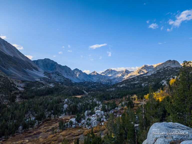
UncleEbeneezer shared with y’all the fall color in the lower portion of Upper Rock Creek, I shot there a week later and my shots were exactly the same(same location and compositions). However before I shot those same shots a week later, I first ventured all the way up the road to the trailhead for Little Lakes Valley at Mosquito Flats. As you may recall, a few fellow photographers and I headed up this trail to Long Lake last year to shoot the Milky Way reflected on the still waters of Long Lake before the clouds and the wind arrived to cut short our photoshoot. I decided to start off my morning hiking a ways up the trail and get some morning shots. I made it as far as Marsh Lake(the second lake on the trail, but I thought it might be Heart Lake) and shot the sunlight on the peaks at the south end of the valley. As I packed up to head back to the car, I noticed some fall color on the hill and decided to hike part way up the Mono Pass trail. About a 1/2 mile past the trailhead at Mosquito Flats, the trail forks, the main trail heads up Little Lakes Valley to Marsh, Heart, Box, Long, Chickenfoot and the Gem Lakes; and the other trail heads west and up to Mono Pass at about 12,000′(this is a hike I want to get in this year). So, to get a better view of the fall color in the valley, I headed up the Mono Pass trail for about a mile until I reached a small pond. At that point I decided to turn around and see the fall color that UncleEbeneezer shot in his post.
It was a rollercoaster day, I headed to South Lake after getting my shots at Upper Rock Creek. It began raining as I headed back up into the Sierra and then it stopped as I approached the parking lot at South Lake. Getting out of the Prius, I realized it was snowing. I ended my day, driving back to the Owens Valley and east and up to the Bristlecone Pine forest in the White Mountains.
These photos were shot with either a Samsung NX-1 and Samsung Galaxy S22 Ultra.
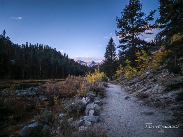
I started up the trail before sunrise and noticed a bit of fall color along the trail with Rock Creek to my left.
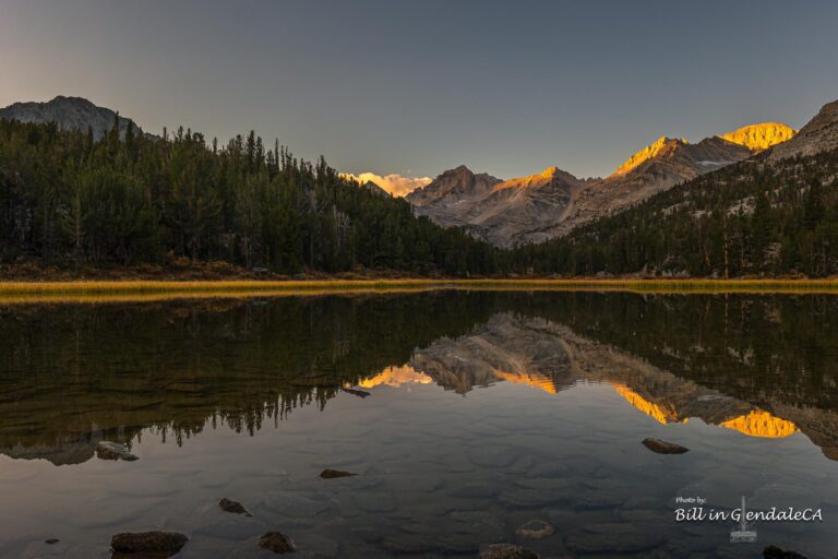
I was unsure if I’d past one lake or two, so I was unsure if this was Marsh Lake or Heart Lake(it seemed a bit heart shaped), and set up my camera along the shore to get some sunrise shots as sunlight hit the peaks at the south end of Little Lakes Valley.
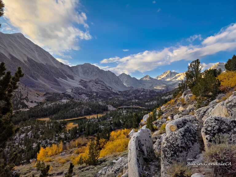
After shooting at the lake, I headed back to the car, but stopped at the fork in the trail and decided to head up the Mono Pass trail for a view of Little Lakes Valley from above. As I climbed the trail, I could see more of the valley and fall color that lay below. I could also see that I was shooting at Marsh Lake.
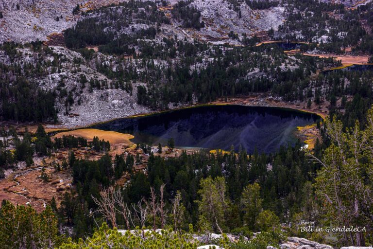
This is Heart Lake from above, you can better see how it gets it’s name.
As I headed up the side of the valley, I could see more fall color further up the trail.
At this point, most of the fall color was below me.
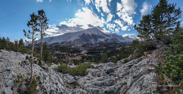
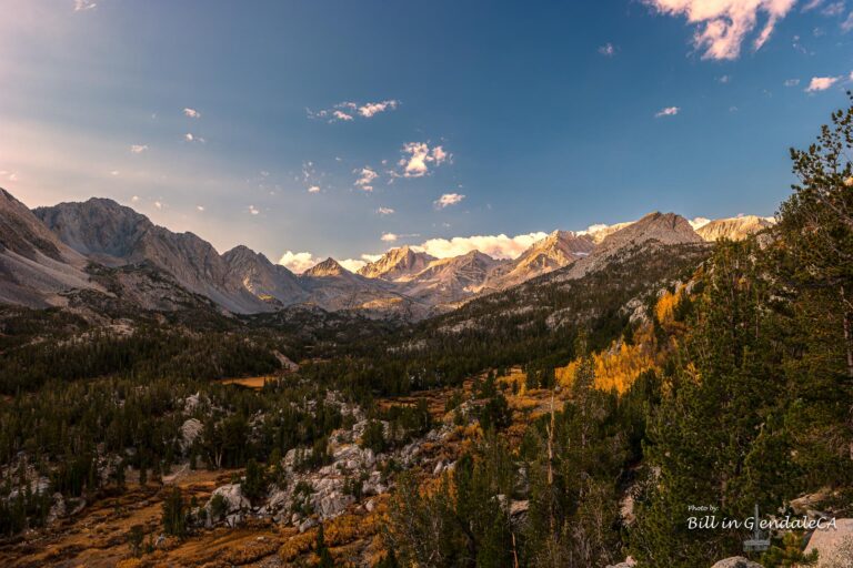
I found this nice break in the trees and shot a panorama of Little Lakes Valley.
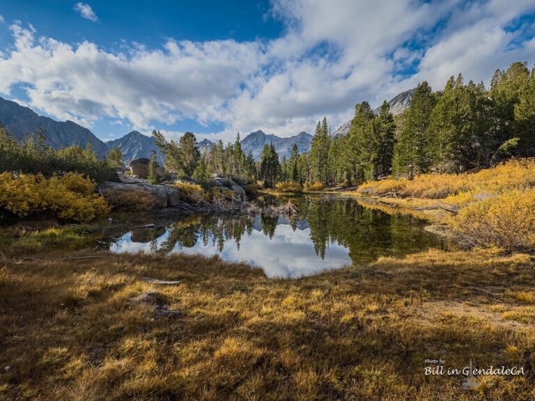
This small pond was alongside the trail and I decided that it would be as far as I’d go that morning. It was getting relatively late and I didn’t have supplies for a longer hike, so I headed back down to the car for fall color around Rock Creek Lake.
Baud
California is pretty.
🐾BillinGlendaleCA
@Baud: One YouTuber calls the Eastern Sierra, California’s Alps. I don’t think he’s too far off. I had my early b-day dinner with Madame and the kid Monday night, I encouraged her to try Little Lakes Valley for a first hike in the Sierra. She had been thinking of Big Pine Creek. Then again, she was thinking May timeframe initially, don’t think the snow will melt off at the higher elevations before July.
Benw
Very nice, ty
mrmoshpotato
Great photos, Bill. Thanks for sharing.
🐾BillinGlendaleCA
@Benw: Thanks and you’re welcome.
@mrmoshpotato: My pleasure.
JPL
Beautiful!
🐾BillinGlendaleCA
@JPL: Thanks, a commenter here clued me into this valley.
Betty
I especially like the sunrise pictures. Lovely scenery.
delphinium
Wonderful photos-thanks for sharing your trip with us!
WaterGirl
That first photo is my favorite photo of yours, ever!
Lovely set.
stinger
The mirror images in the still still lakes are amazing — that second image especially, but also Heart Lake and Small Pond. And I love a path winding off into the distance. Spectacular photos!
lashonharangue
Great photos. I believe the Mosquito Flat trail head is the highest starting point you can drive to in the Eastern Sierra. Very popular on summer weekends.
Steve from Mendocino
Nice composition, good visual movement within the frame, the light is gorgeous. Good job and thanks.
MelissaM
These are really lovely!
I grew up in the ‘burbs of Chicago, so Lake Michigan was the only lake I knew, and I knew you couldn’t see across it. So kid me is like “Heart Lake? that’s no lake!” It took me a while to understand that lakes don’t have to be as vast as the Great Lakes in order to be called lakes.
UncleEbeneezer
Great pix Bill and thanks for the mention/tag. With all the snow they are getting, it’s likely that the waterfalls and lakes should be in really great shape this Spring/Summer (better than the last couple heavy drought years, for sure). We are already talking about various camping trip options :)
UncleEbeneezer
@🐾BillinGlendaleCA: Is she talking day or overnight hike? For day hikes, it’s hard for me to imagine too many better than LLV. It really blew us away the first time (though we could only go so far due to our elderly doggy getting hot/tired). And while it starts at high altitude the elevation gain is pretty chill compared to so many other day hikes in the Sierras.
One day hike that we were considering recently is the Chocolate Lakes Loop out of South Lake (Bishop). Note: hike footage is just first 8 mins, the rest is hike details/info for planning.
cope
Absolutely lovely pictures, thank you. Except for the first picture, I couldn’t see a single piece of evidence of humans or human activity in any of these shots. Earth does, indeed, abide.
Thanks again.
StringOnAStick
@🐾BillinGlendaleCA: The “magic hour” really is magic, thanks for your images.
We have friends who are going to hike the PCT this summer; the Sierras will probably be the part they do last thanks to all the snow.
munira
Gorgeous. That sunrise shot is stunning.
Wag
Beautiful. I love the sunrise photo
Almost Retired
This is great! I’ve been up to Mammoth many times, but I have never heard of Little Lake Valley. That’s where I am headed for my next Sierra hiking trip, after seeing your wonderful photos!
BigJimSlade
Excellent scenery and colors :-)
Kevin
Love the photos. Thanks for sharing them with us!
Mike Mundy
Mike made it up to Morgan Pass in 2013. Alas, not very colorful at the time, except for the fellow photographer’s garb up at the top.
trollhattan
Nice! Classic southern high Sierra. Now I want to go backpacking.
NB–for the first time in ages, it could be a very late opening of the high-Sierra backcountry this year.
🐾BillinGlendaleCA
@Betty: Thanks, sunrise on the mountain peaks always looks nice, when I night shoot, I usually stay up for sunrise. In this case, I just got up there really early.
@delphinium: Glad you like’em.
@WaterGirl: That’s one of the phone pictures, just a snapshot as I started up the trail.
🐾BillinGlendaleCA
@stinger: Thanks, most of the “little lakes” have a nice mountain reflection, especially when the air is still.
@lashonharangue: It is the highest paved road in the state, White Mountain Road is the highest road(I also drove that road to the Ancient Bristlecone Pine Forest) which I also drove the same day. White Mountain road is unpaved after the Bristlecone Pine Forest, but goes all the way to the top of White Mountain Peak at over 14k.
@Steve from Mendocino: Thanks, one thing about Little Lakes Valley, it is hard to take a bad photo there.
🐾BillinGlendaleCA
@MelissaM: Well it is called “Little” Lakes Valley. Most of the lakes in the Sierra are pretty small.
@UncleEbeneezer: I’m looking at several hikes as well, I mentioned Mono Pass as one, but I’m thinking late summer or fall for that one since it is above the tree line at 12k(I’ve never been above 11k and that was 50 years ago).
@UncleEbeneezer: I pretty sure she’ll start with a day hike, though she was asking about whether it was a day hike or overnight. I think she’s open to overnight, but she’d need stuff and you need permits and stuff which I told her about. I see you’ve seen some of Sheetie33’s vids, I’ve been watching them too. I might try the hike to Blue Lake from Lake Sabrina, I think that was the hike I took in the scouts 50 years ago, might be nice for some Milky Way shots.
🐾BillinGlendaleCA
@cope: This is pretty much all in the John Muir Wilderness, so the only sign of humans is the trails.
@StringOnAStick: It was nice and peaceful up there and cold. The kid was talking about May for a hike up there, I was saying July might be better due to the snow.
@munira: Thanks, I recently shot the sunrise at the Alabama Hills, but no lakes.
🐾BillinGlendaleCA
@Wag: Thanks.
@Almost Retired: Good News! Little Lakes Valley is slightly closer than Mammoth, you get off 395 at Tom’s Place just after you go up the side of the volcano after Bishop. I may try a winter hike up near Mammoth, but right now the snow is just too deep, about 6 feet.
@BigJimSlade: Thanks much, the eastern Sierra is hard to beat.
way2blue
Stunning shots.
🐾BillinGlendaleCA
@Kevin: Thanks much.
@Mike Mundy: Your fellow photographer won’t get lost in the woods. The trail past Morgan Pass is closed right now, not just due to snow.
@trollhattan: Right now, I’m thinking June may be the earliest that enough of the snow may melt off, but if we get another round, could be July
@way2blue: Thanks, I may have to post some shots from the Big Pine Creek trail.
agorabum
Marsh Lake never disappoints in the Little Lakes Valley – I prefer it to Heart Lake.
First time I visited it, I also thought it was Heart Lake