On the Road is a weekday feature spotlighting reader photo submissions.
From the exotic to the familiar, whether you’re traveling or in your own backyard, we would love to see the world through your eyes.
Athenaze and Ariobarzanes
By the middle of the 2nd century CE, the Romans had constructed a complex series of frontier installations in northern Britain. Hadrian’s Wall (“the Wall”) is the most well-known element of these installations. Featuring a stone curtain wall punctuated by milecastles, turrets, and forts, as well as ditches to the north and south, it stretched 80 Roman miles from what is now Newcastle-upon-Tyne to the Solway Firth.
Although it might be tempting for Americans in particular to draw a direct comparison between the Wall and the various walls proposed for the southern border of the United States, the Wall was *not* a “border wall”, simply because Romans in Hadrian’s era did not see Roman power as something that had fixed and immutable limits. Rather, the Wall—like comparable installations in e.g. Germany—had a rather different function. It helped Romans control the flow of people between two different kinds of social and economic zones: those “inside” the wall, which were dominated by settled agriculture and settled populations that could be easily taxed and controlled, and those “outside”, which had higher concentrations of mobile pastoralists and fewer big, permanent settlements. The Wall was therefore one element in a much wider frontier zone, which—to the Roman mind—separated peoples who had already been incorporated into the Roman imperial order from those who had yet to be properly “civilized”.
Today, Hadrian’s Wall Path—an 84-mile-long hiking trail maintained by Natural England—allows ramblers to explore the old line of the Wall. Adhering as closely as it can to where the Wall once stood, it leads hikers through open country, charming villages, and archaeological parks dedicated to the UK’s long past (Roman and otherwise). Visitors can plan true through-hikes, stopping at a different B&B every night, or they can walk bits of the trail on day trips. We’ve completed two separate through-hikes: in August and September of 2010, we followed the path from Newcastle-upon-Tyne in the east to Bowness-on-Solway in the west over a period of nine days; eight years later, in May and June of 2018, we spent eight days hiking in the opposite direction. The pictures that follow are drawn from both of those trips, but are organized to display the west-to-east route (we think this is the best way to walk the trail, since it builds to a dramatic climax with the walk into vibrant Newcastle).
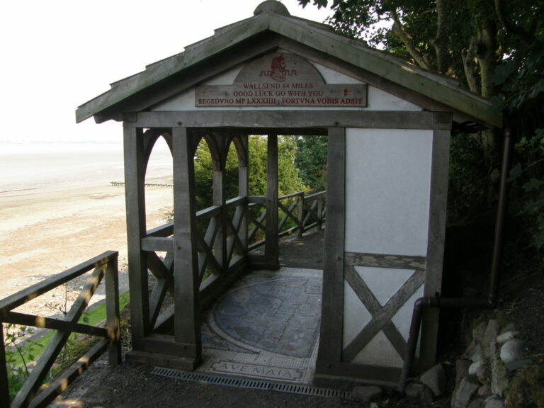
From the west, the path proper begins at Bowness-on-Solway, a quiet little town on the Solway Firth. English Heritage maintains this nice little pavilion, where hikers just starting out on their journey can gaze out over the tidal flats, and those finishing up can flop down and rest while they wait for the bus to Carlisle. Locals spend time here too. When we ended our first hike here in 2010, an old man in a powered wheelchair drove into the pavilion while we were taking a well-deserved break, stopped to look north toward Scotland, and muttered “Savages!” Memories of the violent raiding conducted by the English and Scots against one another across the medieval and early modern frontier apparently live on.
The Latin on the sign mounted on the building’s pediment translates the English above it; Segedunum was (probably) the Roman name for the fort at the wall’s eastern terminus at what is now Wallsend. On the threshold, a mosaic greets visitors with the legend “Ave Maia” (Greetings Maia), a reference to the probable name of the Roman fort that once stood here at the western terminus, Castra Maia (“the Greater Encampment”).
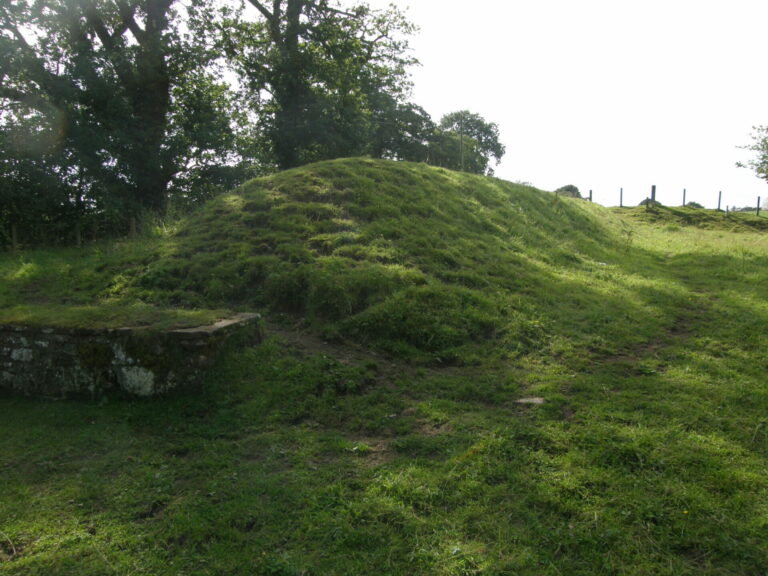
At Dovecote Bridge, hikers from the west are *finally* treated to their first sight of genuine, in-situ surviving remains of Hadrian’s Wall. No, not the stonework you see on the left edge of the shot, but rather the big mound of turf. It covers a few courses of Cumbrian sandstone blocks, which were excavated in 1983 and reburied in the early 2000s to protect them from erosion.
On our first trip, when we were walking from east to west, we ran into a couple of Dutch hikers a few miles to the west of here. They had started at Bowness-on-Solway, were on the third day of their hike, and desperately asked us if they would ever actually see some of the Wall. They were really excited when we said, “Yes, you’re almost there”—and almost equally crushed when we told them that the first section they’d see was indistinguishable from a pile of grass-covered dirt.
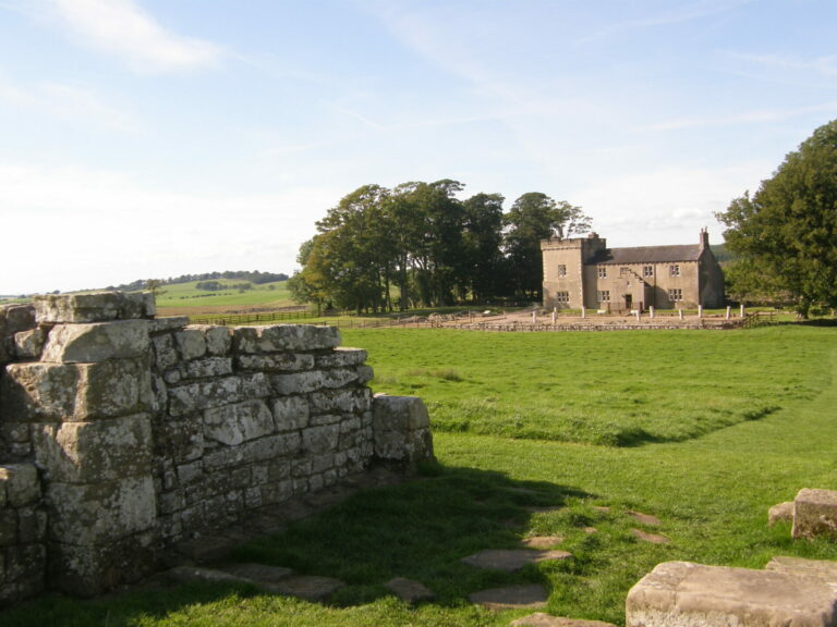
Just a couple of miles away from Lanercost, eastbound hikers starved for their first real glimpse of the Wall itself suddenly go from rags to riches. They first encounter a tall stretch of Roman wall rebuilt in the Victorian period at Hare Hill (mile 28.5), several low courses of stones consolidated more recently by English Heritage at Banks (mile 29), and then the spectacular remains of the ancient Roman fort at Birdoswald (mile 32).
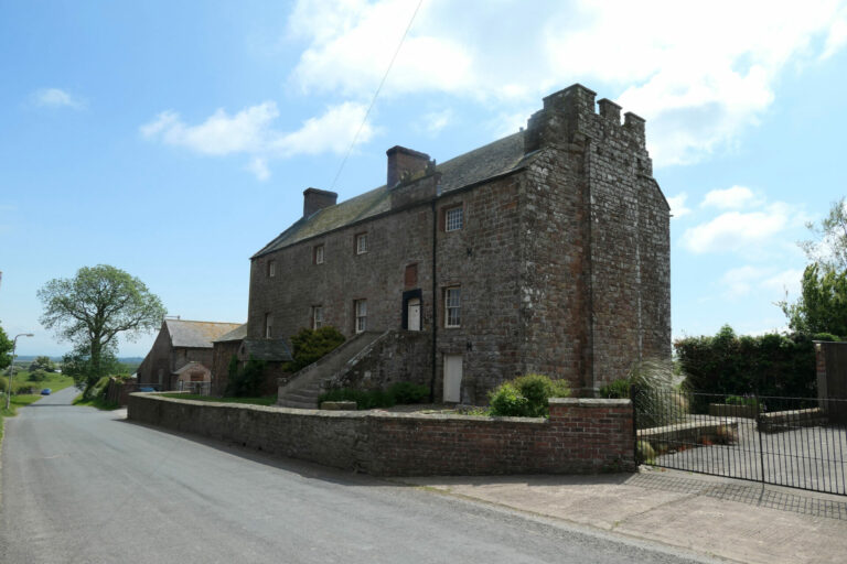
Probably known to the Romans as Banna, Birdoswald was one of about fifteen major Roman military bases that were situated at strategic points along or near the Wall (some of which predated the Wall itself by several decades). Birdoswald sits right on the Wall; like other forts in the area, it housed a garrison of non-citizen auxiliary soldiers levied by the Romans from provinces in their empire. The photo above shows the remains of the fort’s south gate and, in the background, a 17th-century farmhouse that has been recently converted into a bunkhouse. Both the Wall and the path run just on the other side of the farmhouse.
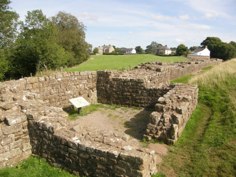
East of Birdoswald, hikers are treated to the longest and best-preserved sections of the Wall that have been consolidated by English Heritage. This section sits just to the west of the village of Gilsland (part of which can be seen in the background). The foreground is dominated by the lower courses of one of the observation towers (“turrets”) that the Romans constructed to house sentries along the wall; typically, each mile of wall had a garrison house (“milecastle”) at either end, and two turrets like this between the milecastles.
Modern archaeologists have created an indexing system to designate milecastles and turrets by numbers and letters. Milecastles are numbered sequentially by Roman mile, beginning from the Wall’s eastern terminus at Wallsend in Newcastle; turrets take the number of the milecastle immediately to their east, and then either “a” (for the first turret one encounters moving westward from a given milecastle) or “b”. This is officially Turret 48a, i.e., the turret immediately to the west of milecastle #48.
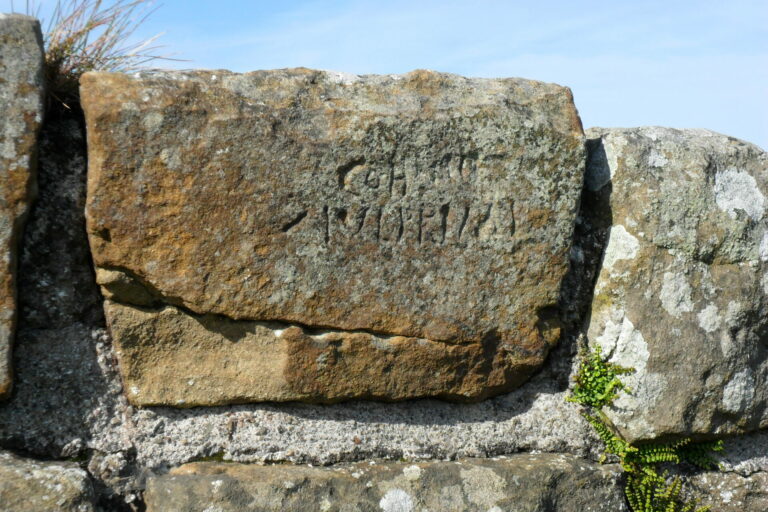
On the stretch of the wall just to the west of Turret 48a, hikers with sharp eyes can pick out a stone with markings chiselled onto its surface by the original Roman builders. It’s a great example of a “Centurial Stone”—an engraved stone recording the military unit responsible for laying the stonework along a particular stretch of the Wall, usually in lengths of approximately 25 to 35 feet. About 200 of these stones still survive, some (like this one) in situ, others in buildings constructed from plundered wallstone. The inscription on this one reads:
COH VIII
IUL PRIMI
Roughly translated, “this chunk was built by the soldiers of Iulius Primus’ century, which is part of the eighth cohort” (a legion in the second century CE typically consisted of ten cohorts, most of which were subdivided into six centuries, each manned by about 80 soldiers under the command of a centurion).
kalakal
Thank you for posting this, brings back memories. Went on many school trips to the wall. More towards the East mainly, I must have been to Vindolanda a dozen times. Looking forward to the rest of the series. I like the ‘savages’ bit 😀
J.
What a great thing to do! We love to go hiking, especially in places with lots of history. Thanks for sharing.
eclare
Thank you for the photos and history. Fascinating.
Wag
When I was a kindergartner my family lived in Newcastle for a year. I have distinct memories of walking sections of the wall, as well as exploring the Northumbrian castles along the coast. I am looking forward to the rest of the series.
AM in NC
Thank you for sharing the photos and the narrative! So interesting and beautiful.
This very much makes me want to do the hike. Logistical question for you: do you hike with a pack carrying your gear between each B&B on your stop? And if so, is it a pain to have it with you when you do “side trips” to explore (eg: Carlisle)? Thanks again!
Dorothy A. Winsor
Your pics and story are fascinating. It’s easy to imagine the people building and serving along this wall, and then the people building from it.
Barbara
I loved exploring this part of Northern England. The pictures are lovely.
Kabecoo
What a fantastic route! And even better narrative! Thank you
twbrandt
Lovely pictures and narration! I look forward to parts II and III. (Also thinking I might do that hike myself!)
JCJ
Lovely! In 2011 we took a driving tour around England and Scotland. There was a huge storm with ferocious winds which would intermittently blow through the area. We went to the part of the wall at Housestead. It was lovely, but then another wave of the storm rolled in with ~70 mph winds and rain. I used my umbrella as a shield and walked back to the visitor’s center with my daughter using me as her shield. When we got to the gate that prevents the local sheep from wandering off I turned around to make sure my daughter was still behind me. Not only was she behind me, but so were three others who were trailing her to use us as their wind/rain shields. Later on that trip when we went to Edinburgh the castle was closed due to the winds.
Ariobarzanes
@AM in NC: We were a bit masochistic and carried our packs with us on both hikes. Generally, visiting sites along the route with our packs on was not a problem, though at one or two sites we needed to leave them in lockers.
That said, a lot of people who do through-hikes these days sign up with a travel services company to move their packs from one B&B or hotel to the next. There are definitely outfits like that serving Hadrian’s Wall country, but since we didn’t use any of them, we can’t give you good recommendations.
AM in NC
@Ariobarzanes: Thanks for the response. I think we’d carry our packs, but wanted to make sure that was feasible and not a huge hassle. We’re in our mid-50s so I think it’s doable still for us.
sab
“Oh to be in April now that England is here” announced by a friend on a freezing wet day in October while mournfully gazing at Vindolanda on the wall.
knally
Always meaning to visit the wall and this has certainly encouraged me to actually plan something!
Miss Bianca
So.cool. Thank you!
MelissaM
Locals. Snort.
This is great, I’m loving the pictures and the information. Looking forward to the rest of the hike!
Origuy
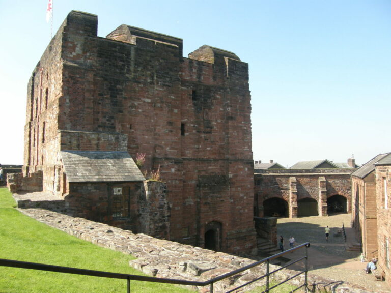
Thanks for the memories. I was in Britain in 2011. I drove up from Manchester and stopped in Carlisle. I saw the castle and the nearby museum, which has a lot of information about the area in later periods as well as the Roman. They have exhibits about the Border Rievers, who were a group of families that lived in the anarchic Borders before the Union of the Crowns, including some of my ancestors.
When I was at Lanercost Priory, I wanted to go to Bowcastle and see the large Anglo-Saxon cross at St. Cuthbert’s. A nice English Heritage lady drew a map on a napkin to show me how to get there. (I really should have bought a map!) The route took me along some tiny roads where sheep were grazing and I had to wait for them to get out of the way. It’s very remote.
JustRuss
Many years ago I visited an acquaintance in Newcastle and they took us on an excursion to the wall. Thoroughly enjoyed it, clambering over a fascinating piece of history in a beautiful setting.
StringOnAStick
Lovely! This has been on our list.
Ariobarzanes
@JCJ: We had a day like that too on our first hike–blustery, winds reaching gale strength, some rain. Not a whole lot of fun when you’ve got a 25lb pack on your back!
Winter Wren
Fascinating history and lovely pictures. Looking forward to the series!
Athenaze
On our first trip, we met a delightful person, Max, who was working for English Heritage at Lanercost. He was one of those people super excited about the history and wanting to share. We talked to him until other visitors showed up, and he had to attend to them. The next day, we saw him again at Carlisle Castle (also an English Heritage site), and chatted again. On our second trip almost 10 years later, we decided to ask about Max at Carlisle Castle, and he was still working there, although about to move on. He didn’t remember us, but I think was touched that we remembered him and sought him out.