On the Road is a weekday feature spotlighting reader photo submissions.
From the exotic to the familiar, whether you’re traveling or in your own backyard, we would love to see the world through your eyes.
TKH
More pictures of geology and landscape
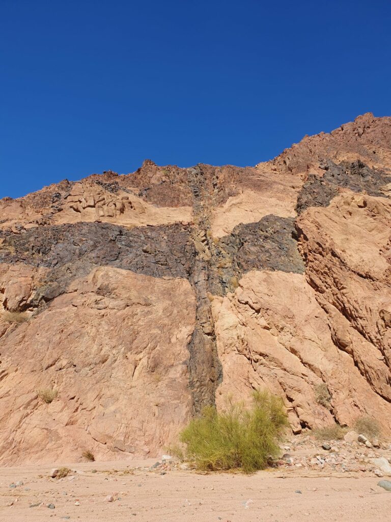
The Sinai peninsula was lifted out of the sea by lava pushing from below. In this process cracks opened up at right angle to the direction of the lift. These cracks were filled in by lava which then cooled. The color of this fill is different than that of the surrounding granite, which is typically grey or pink. As a consequence one can observe these black veins that are running as a straight line for as far as one can see.
This particular spot was unique in that two of the fractures crossed each other leading to this black cross on the mountainside.
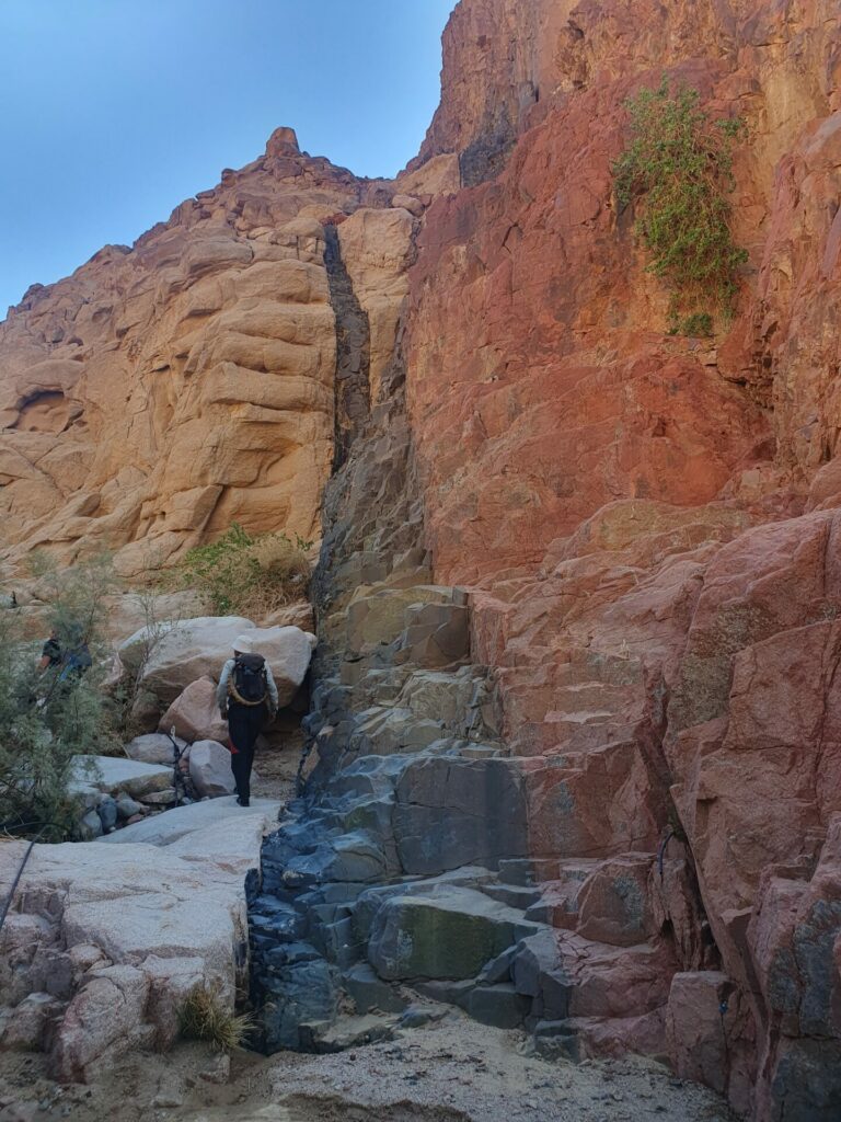
One such crack with one of our guides for scale.
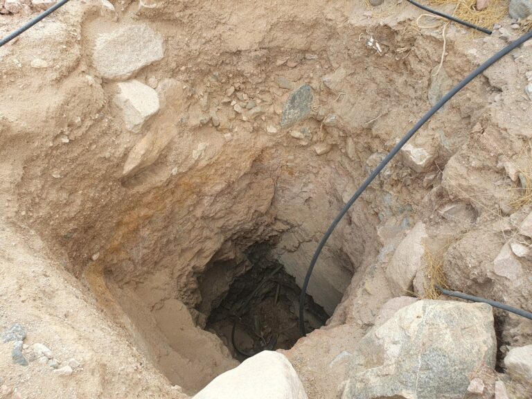
Whether an area is inhabited by people is determined by the availability of water. When it rains in the rainy season most of the water runs off as surface water in the form of flash floods of immense power. The Egyptian government has funded the construction of dams some of the major wadis leading to the ocean to retain some of this water. One would expect this water to be piped to where the population lives, but owing to low population density this is not how it works. Instead the water is retained in underground cisterns from which water can be retrieved via pulley to provide water for animals and humans (we avoided drinking this water).
In minor wadis individual Bedouin can build wells such as this one. These are invariably built by hand with pick axe and shovel, dirt being hauled up via pulley. Water is pumped up with gasoline-powered pumps through thees black PVC pipes that are ubiquitous, the same way they are in SE Utah. This particular one is dry, but we saw much deeper wells of this kind that had water in them.
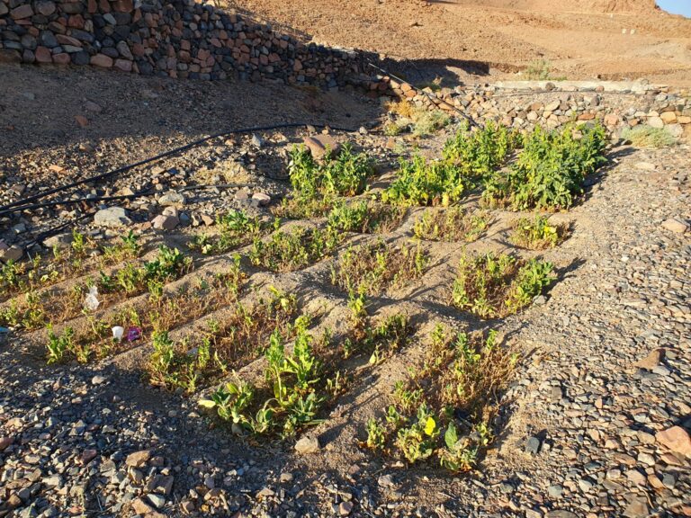
This a typical Bedouin garden with depressions of about 2 x 3 ft dug into the soil. These will be flooded every couple of days to provide water to the plants. I don’t know exactly what this crop is, but we saw some “interesting” plant life.
An anecdote from the trail: We had been climbing a steep wadi/canyon for the entire morning when we happened on a garden that featured some dried poppies and marihuana plants. There was a hut/shack nearby, built next to a big rock and covered with a blooming clematis-like plant. The owner invited us in for chai as is the custom and then had his gardener prepare lebba for us (see Pt. 1). As we entered the shack the smell of pot could just not to be ignored. As we found our spots to sit one of us touched a blanket that separated a small side room. As the blanket fell down bags of weed packaged and weighed out for sale were revealed. Our local drug lord however was undisturbed and continued his conversation with our guides. We had lunch in this most welcome shade. As we were done eating the owner prepared to leave and carefully and impeccably arranged his keffiyeh (head shawl) on his head, donned a camouflage jacket over his impeccably white thawb and took off. He was not some hick farmer, he was a businessman and dressed the part.
Our guides assured us that their tribe was not participating in the drug trade and it was “them other guys” who did that.
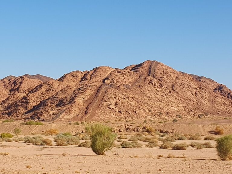
Back to a less sensitive topic than the local variety of agriculture, namely geology. Here is another form of seams running through the landscape that are not volcanic in origin (I think). This one could see running across the wadi we were in but I don’t know whether there was a wider scale to it than just this wadi
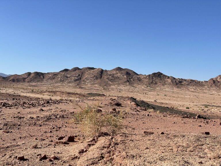
This another illustration of what happened when the peninsula rose. On the horizon you see six more or less vertical stripes where lava has filled in cracks formed when the bulk rock cracked as the ground rose. Closer to the photographer running from bottom right slanting up to the left is another of thees cracks filled in with black lava.
As I have said elsewhere in this series of posts, the lack of ground cover provides an opportunity to see geology that in most other places in the world that I have been to would be covered up by top soil and flora.
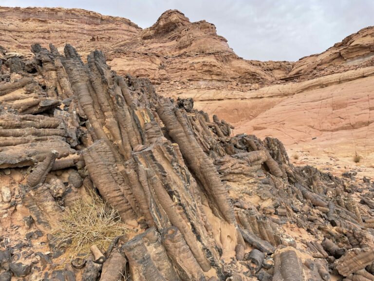
This is a unique site that is an ancient undersea hot vent where mineral rich water from the Earth’s interior was pushed up and reached the ocean bottom where owing to colder temperatures the minerals crystallized out forming long tubes that were hollow inside and filled with still hot water and the dissolved minerals. There are many such vents in the world’s oceans. they are noticeable for their unique fauna and bacterial flora.
When the Sinai peninsula rose the hot vent shown in this picture rose above sea level and is now the site the Bedouin call “the volcano”.
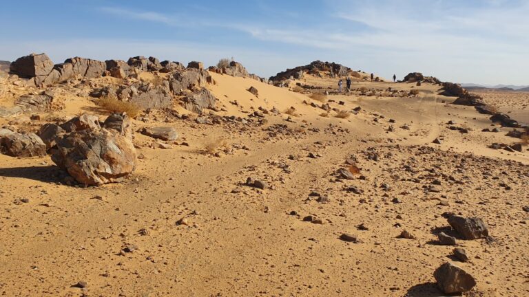
Another scar running for miles through the landscape. This is one of the biggest ones we saw. The dark rocks on the left and the right are different from the bulk rock in this area.
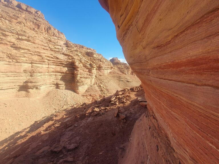
Some colorful layered sandstone with iron minerals included. The yellow ones are aptly called limonite, the red ones are hematite. They are iron oxides with different degrees of hydration (StringOnAStick, the resident geologist if memory serves, should feel free to correct me if I completely bungled this).
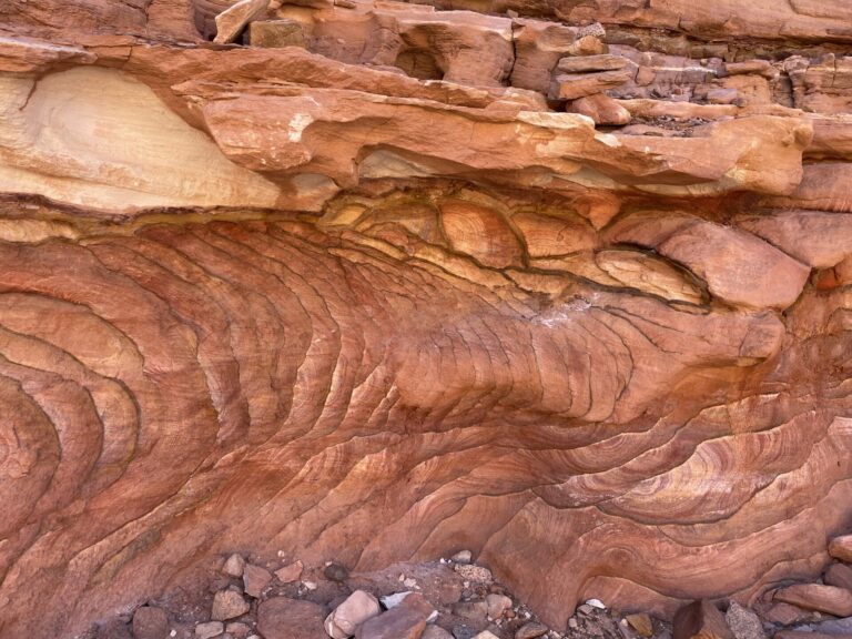
Another example of colorful sandstone.

Manyakitty
Trip of a lifetime. Wow
Baud
Geology is cool.
OzarkHillbilly
Stories like this are what make travel so worth the trouble.
Really cool and certainly unique.
Love it.
Thanx for all of it TKH.
knally
I’m really enjoying this On the Road. It’s an area I’ll never be able to see for myself and it’s starkly beautiful.
The geology is just fascinating!
Traveller
Your writing and images on the Sinai have been fabulous….they together, the writing and the images, are almost sufficient to transport a person there, there into that wondrous rocky desolation. Thanks for taking us along. Best Wishes, Traveller
Dorothy A. Winsor
That’s fascinating.
blindyone
Thanks for this travel series. I love to see interesting rock formations and appreciate the explanations of what created them.
Betsy
Amazing and interesting.
Some of the garden plants look like they could be spinach, especially in that first rank across the bottom of the picture.
The taller ones in the rest of the garden, maybe amaranth, or a spinach-like plant called “New Zealand spinach”?
stinger
Love this series!
PBK
Just an amazing part of the world and your superb pictures and writing are doing it the justice it deserves. Thank you!
StringOnAStick
Thanks for the shout out, but in minerals Triassicsands is the better geologist, my area is geomorphology (landforms) and groundwater, and wow is this some interesting geomorphology! I’ve been meaning to look up the details of plate tectonics for this area because this density of magma intrusion features is very unique. I will get to it later today and hopefully have something to add to the discussion.
pat
Amazing landscape, thank you! What a trip, indeed. But it’s hard to imagine anyone actually living there….
mquirk
I hope you got to go to the Monastery of St. Catherine. It’s got a fascinating history, including being both a Christian and a Muslim holy site.
cope
This series of pictures and stories is great, thank you for letting us see a glimpse of such exotic locales.
The first picture really spoke to me because it shows a classic cross-cutting relationship: the vertical dike of darker rock cuts across the horizontal dike indicating it is the younger of the two dikes. The picture of exposed volcanic vent tubes is just spectacular. I have never seen a picture of them except on the sea floor.
I wrote a paper on the tectonic history of the Red Sea (which I discovered I still have a copy of) when I was in grad school but didn’t expand my topic enough to cover the geologic history of the Sinai so it is interesting to me to see expressions of those tectonic forces on the land adjacent to the Red Sea.
Thank you again for taking me places and showing me things I will never see.
BigJimSlade
Great set! Undersea hot vents not undersea anymore!
way2blue
TKH. your photos of these fascinating rock formations piqued my curiosity enough to ping Mr Google. The Great Rift Valley of Africa extends up the Red Sea, then shifts to the east side of the Sinai Peninsula before becoming a left-lateral fault through the Dead Sea region. That’s today—not the rifting marked by the older volcanic intrusions. With the current rift marking a boundary between two tectonic plates. Very complicated. And very cool…
TF79
Super cool – I love going hiking with geologists who can piece together the history of the land.
TKH
Thank you all for your kind words, you are all most generous
Chris T.
@StringOnAStick:
Aren’t the lava flow areas in Idaho (near Craters of the Moon) and Utah (all over the plateaus) pretty similar?
cope
@Chris T.: My understanding of the flood basalts of the NW is that they are the product of magma from a plume or “hot spot” under the North American plate following fractures through the crust to spread out over the land. This is different from the basalt dikes associated with the plate motions of the Red Sea/Sinai region.
Dmbeaster
@Chris T.: Those are surface flows. The pictures show dikes that solidified underground. It is very unlikely given the small size of the intrusions that magma penetrated all the way to the surface via those dikes.
Maybe there are dikes beneath the surface features in Idaho or Utah, but unlikely as to Idaho.
The volcanics of the Snake River plain in Idaho are basalt outpourings from the passage of the Yellowstone Hot Spot, which just fried the entire crust as North America drifted west over it.
Recent Utah volcanics (under 5 million years) have been created by crustal extension, and is a phenomena found throughout the Great Basin for the same reason (you find them in Nevada, eastern California and northern Arizona). Maybe there a buried dike formations underneath, but most of it represents magma getting through to the surface as the crust is stretched.
ronno2018
wow! very cool. I had no idea the Sinai was like that!