On the Road is a weekday feature spotlighting reader photo submissions.
From the exotic to the familiar, whether you’re traveling or in your own backyard, we would love to see the world through your eyes.
TKH
After cresting the cliffs to the west of Capitol Reef/Glen canyon National Recreation Area I had to find my way into Stevens Canyon by way of an unnamed canyon which in the long distance hike community has acquired the name “Exit” canyon. Hiking towards the West, for me it was the “Entry” canyon that would get me on level down so that I could connect to Stevens even further down. I had been to Stevens Canyon before, in fact some of the pictures are from my earlier visit, but the descent from the crest and the “Exit” canyon route were new to me. I had a few waypoints for the approximate location of critical features of the route, the rest I typically make up as I go.
I hope that you enjoy the pictures from one of the more remote areas in Southern Utah!
Cheer
Thomas
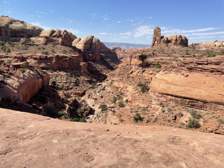
This is “Exit” canyon the way you first see it hiking East to West. Holy smokes, this does not look like an exit or entry at all! But rancher Baker got cattle out of there and others have come up or gone down this way, so there must be a way in. And of course there is.
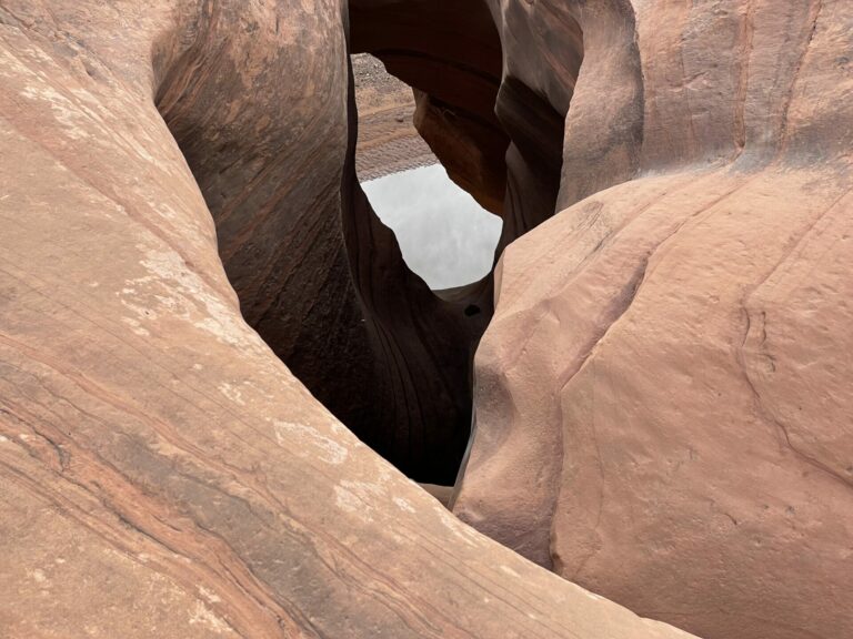
Hidden from view is a weakness in the cliffs, maybe some 50ft in width, that allows you to get through the top sandstone layer. Some further improvisation informed by experience and intuition as well as trial and error then gets you into the drainage that you see slightly off-center to the left, right above the immediate foreground. You follow this drainage until you can climb out to the left onto a ledge that runs high above the drainage. The drainage has several massive dryfalls that you can only get past if you walk the ledge.
A view from the ledge. In the center of the picture you see the inner drainage zig-zagging towards the distance. You have to find your way on the ledge to the left. In principle you could also walk on the right ledge, but I am not aware of a way to get off the ledge on the right into Stevens Canyon.
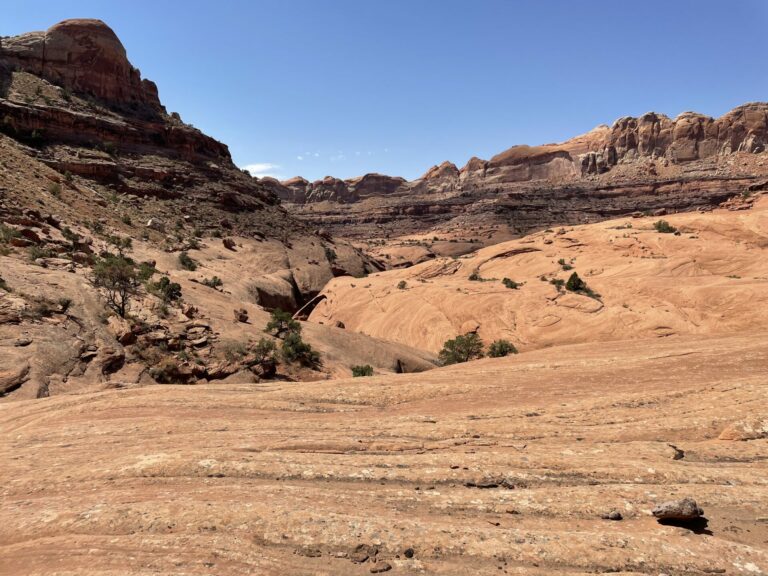
The ledge overall slopes badly into the drainage below, but you can almost always find a level bit to walk on that does not slope too badly. And sometimes you just have to take your heart in both hands and get across an uncomfortable stretch.
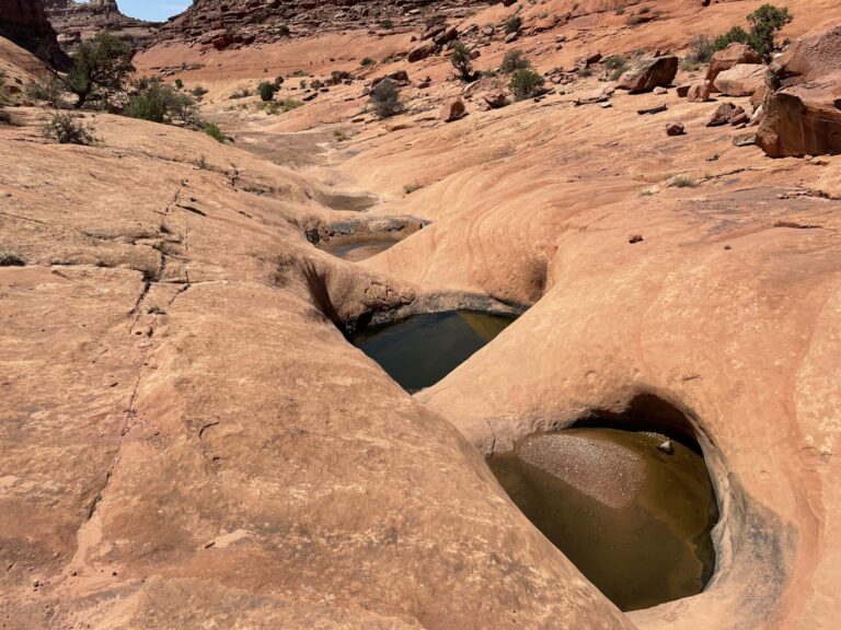
In its lower reaches Exit canyon has potholes where rain falling onto terrain to your left drains across the ledge into the drainage below. These potholes often occur in strings (and I have no idea why this happens) and often only some of the potholes contain water while others are dry (and I have not idea why this happens). The water is typically clear and easily filtered as well as, most importantly, cold.
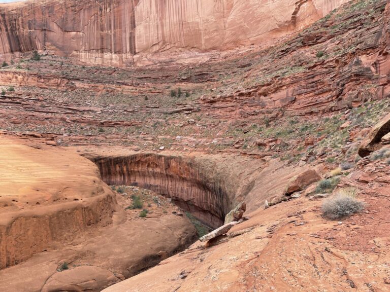
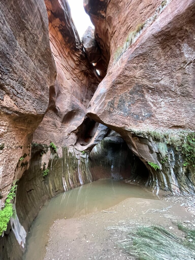
This is a view of the inner canyon of Stevens canyon. At the upper end of this inner canyon is a massive dryfall (about 100 ft) that you can’t climb and the walk on the ledge shown in the foreground is the way to get down canyon. After about two hours of walking on this ledge there is a very steep slickrock ramp that gets you down into the inner canyon.
Below the dryfall mentioned earlier is a giant pothole. This picture is taken from right above the dryfall through holes in the intricately carved sandstone to the pothole below.
Further downstream from the ramp I mentioned is the next obstacle, Poison Ivy hill. Here erosion of the surrounding cliffs has piled up a mountain of rocks and dirt. This mount has been claimed by poison ivy and you have to watch it like a hawk. It does not help that there is a spring right in the middle of the narrow use trail that leads across the mount, which makes the dirt really slippery. I have descended the mount mostly on my ass after my feet lost traction in the slick mud.
This picture is taken from the downstream side of the mount and offers a view of the crypt and the lush vegetation that depends on the water seeping out of the mount. During a flash flood this would be an “interesting” spot to hang out.
Stevens Canyon is very twisty, often making 180 degree turns, leading to this picture of a gooseneck.
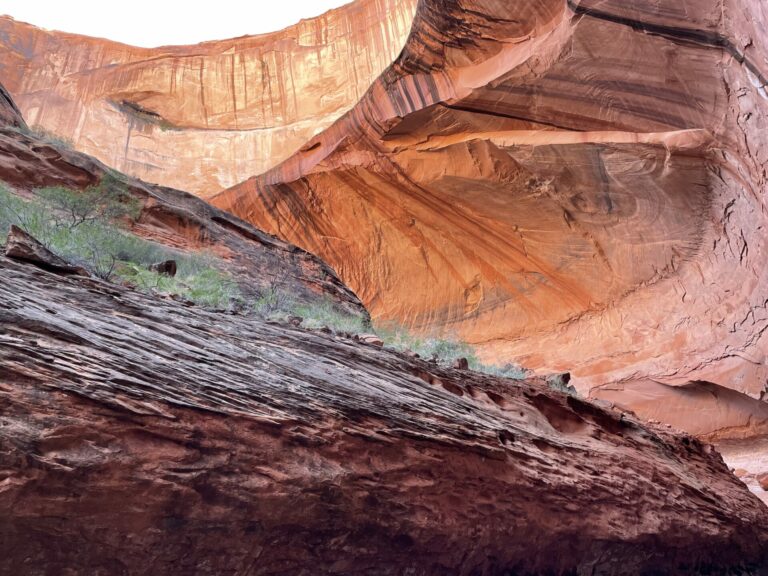
Never a dull moment in this canyon, color, light and shape change constantly.
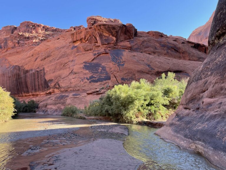
After exiting Stevens and wading the Escalante, a look back to the junction of the two canyons. The entry to Stevens is right by the bright green brush in the center of the picture. This location is about a 45 min wade (I pity the longitudinally challenged!)/walk from the bottom of Coyote Gulch.
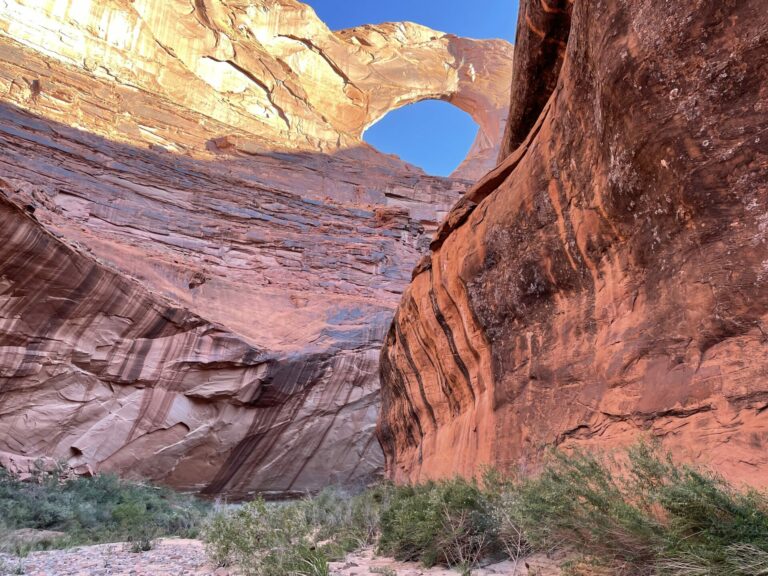
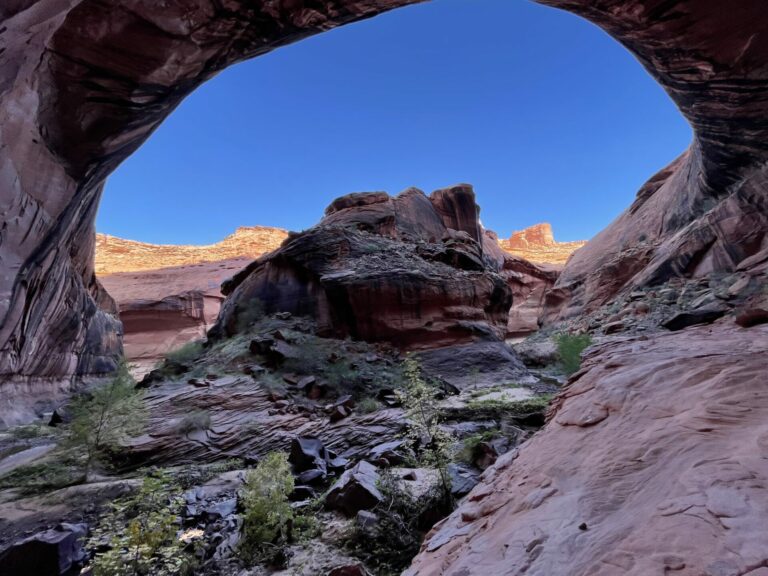
Stevens Arch is a major landmark at the bottom of Stevens Canyon. It is a massive hole in the wall. Air Force fighter pilots like to use it as a landmark. I was quietly hiking along minding my own business when in rapid succession three F-18 or F-22 were screaming across the canyon at low altitude. You can imagine how that noise reverberates in a narrow canyon.
Wag
I love the play of light in the last three photos. Thanks again for sharing.
Amir Khalid
American fighter pilots fly through canyons to exercise their skills. At least, that’s what all the fighter pilot movies tell us. I sympathise with you and everyone else whose quiet contemplation of the majestic beauty in these pictures was rudely interrupted by an F-22 flyby.
Betty
Challenging doesn’t quite describe your experience, but the photos explain why you do this.
BretH
Thanks for the great photos and excellent writing! I want to teleport to some if those locations, but understand that I would miss the many subtler delights found in the way down/in.
TriassicSands
@Amir Khalid:
In 1986, when Halley’s comet returned, my father, brother, brother-in-law, and I went to Utah and Arizona to view the comet. The further south we went, the better the viewing. Initially, I told them I would meet them at Muley Point, which sits thousands of feet above the San Juan River. There are two main levels. Muley Point at the top of towering vertical cliffs, an expansive level area far that stretched to edge of the canyon rim through which the river flows far below. From Muley Point you can see the Goosenecks of the San Juan, a spectacular formation.
At one point, as we took in the magnificent scenery and serene quiet, a camouflaged B-52 bomber flew beneath us across the expansive area and disappeared around the cliffs in the distance. I’ve never seen a more incongruous sight in my life. It was, at the same time, impressive and upsetting. Somehow, an airplane that can carry nuclear bombs didn’t really seem to belong in the midst of so much natural beauty.
Nothing plagues the desert west of Utah and Arizona, including the Grand Canyon, more than airplane and helicopter tourist flights. One of the reasons to go to those places is to escape the noise of “civilization” and absorb the natural sounds of the desert. Planes and helicopters destroy that and should be banned entirely from flying over such areas — unless they airliners flying at 30,000+ feet. I’ve long believed that it’s important for people to visit those kinds of places when they are young and healthy and not wait until they need cacophonous machines to allow them to see the sights. There are now more than 300 flights a day, on average over the Grand Canyon
The goal should be to experience natural beauty. There is nothing natural about helicopters and planes in the wilderness.
OzarkHillbilly
The pictures most definitely yes, but I appreciate the stories that go with them even more.
cope
Wonderful pictures and a lovely ramble nicely told. Thank you.
Gin & Tonic
Very much appreciate the pictures and the words that go with them. As I’ve noted, I love this area and have been there several times, but by now the days of even contemplating a trip like yours are pretty far in the rear-view mirror.
Spirula
The pictures are great. I think the “pot holes” are the result of whirlpools forming in the same spots during fast moving floods. Over many flooding episodes the whirlpools carve out holes.
Anyway
Love this so much – the description of the trail, canyon and the pictures – all of it.
Last year I was in the area and hiked up to Cassidy Arch – no aircrafts to disturb the peace just other hikers. It was nowhere as challenging but enjoyable nonetheless.
Elizabird
Lovely visual hike with you! The contrast of water and rock, and where-water-once-was-on-the-rock, is endlessly interesting. I’ve always thought that the beautiful vertical striping of desert varnish, as in your final, Stevens Arch photo, look like the unfurled wings of thunderbirds.
mvr
Thanks for these photos and the narrative! The photos are great. And, among other things the narrative gave a good sense of your determination to get there.
Netto
After a hot hike to Observation Point in Zion, I sat enjoying the view of tourist traffic, so far below me that no sound made it to me. Then I heard a distant rumble, and I saw two specks flying below me from the direction of Springdale. As they approached the abrupt bend of the canyon at Angels Landing, the two A10s pulled up out of the canyon over my head, leaving a lingering echo that dispelled any semblance of escape from civilization.
West of the Rockies
@Amir Khalid:
Well, they’ve got to train to destroy The Death Star somehow…
STUNNING photographs, Thomas! What a hike! What age-range of people can take on your hike?
StringOnAStick
@TriassicSands: Completely agree. The rise of helicopter tourism in areas that are otherwise wild and scenic is an abomination. The desert country of the US west is rife with it now. We chose not to do the helicopter trip to see the Nai Pali coast in Hawaii for that reason, and hiked the existing trail as far as we could instead; it was plenty scenic on foot. And quiet too.
StringOnAStick
@Spirula: As a geologist in my prior life, I concur. The rocks and sand that spin around in those whirlpools during high water flows do a great job of continuing to enlarge the hole. It’s faster in sandstone though I’ve seen great examples here in central Oregon along the rivers, in very dense nonvesicular basalt, with the grinding stones still in place, waiting for higher flows so they can go another round or two.
StringOnAStick
Fabulous photos and story Thomas! We are so lucky to have such places in our country, and to have your photos and stories about them.
TKH
@West of the Rockies: There are out of shape twenty-somethings and in shape people in their sixties and seventies, so I would say that age is not the most important factor per se. You have to be able and willing to hike 10-12 hrs a day with a ~ 25 lb pack. That’s really the core requirement for the route I described in this two-part submission.
Alternatively you could come in from the bottom, from Coyote Gulch. That would knock off a couple of days and a few pounds of pack weight. Four days/three nights would get you to Exit canyon and back out. This approach would also eliminate some of the orienteering challenges inherent in the route coming over the circle cliffs. As well as eliminate the need for an eighty mile hitchhike to bet back to your car.
way2blue
A remarkable trek in a remarkable corner of the country. TKH, thanks for sharing this glimpse. The textures, shapes & colors of the sandstone cliffs are extraordinary. Your last comment reminds me of when I was mapping a valley in the Wasatch Mountains—Air Force hot dogs would scream through the canyons on training runs and buzz me. Very memorable…
TriassicSands
@StringOnAStick:
I hiked the Na Pali Coast trail in January ’86. It was beautiful. You did the right thing to walk instead of fly.
The photos in this OTR should be an inspiration to everyone who can to make and take the time to visit some of the red rock country (especially in Utah) before it is too late. Capitol Reef is a wonderful park and worthy of many visits. Many of the happiest, most fulfilling days of my life were spent hiking, photographing, and rock climbing in Utah.
Of course, the same problem that plagues virtually every park today — too many people — is one we can’t do anything about. I was lucky enough to spend considerable time throughout the red rock country before it became so crowded. Still, as beautiful as photographs can be they are no substitute for being there. And if you are relatively young and healthy it isn’t that hard to escape the mobs. Most tourists never get far from the road, though there is plenty to see from there.
TKH
@StringOnAStick: It surely would be interesting to be in that spot when the water is running high to see this process live. Alas, it is “interesting” in the sense of the Chinese curse “May you live in interesting times”.
West of the Rockies
@TKH:
Thank you!