On the Road is a weekday feature spotlighting reader photo submissions.
From the exotic to the familiar, whether you’re traveling or in your own backyard, we would love to see the world through your eyes.
TKH
Since 2018 I have crossed Southern Utah on foot twice by two slightly overlapping routes when such overlap could not be avoided. I just concluded my second traverse with a hike through the Grand Canyon, or rather, parts of it.
I entered the National Park close to its Eastern border using the the somewhat notorious Nankoweap trail. I then walked down on the right bank to near the junction with the Little Colorado River where I caught a ferry ride with one of the rafting parties to the left bank. After walking downstream for a couple of days I ascended to the zoo that is the South Rim for a resupply, descended to the river along the zoo that is the South Kaibab trail and ascended the other side on the North to North Rim. After two days hiking through the North Kaibab National Forest I descended back down to river level, walked along the Colorado for two days and then ascended to what’s called the Arizona strip.
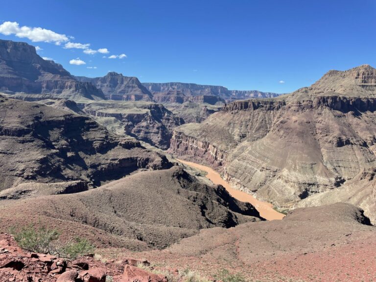
Along the way I took some pictures of the Colorado the way few people who are not backpackers or rafters ever see it. Most visitors drive along the highway on the South Rim and view the canyon from on top for about two hours (this is literally true the rangers tell me) and then move on.
It was an absolutely mesmerizing trip, even if the last days along the river and the climb out consisted of some of the most demanding hiking hiking I have ever done. At the moment I categorize this last section as type 3 fun, not fun while doing it and not fun in the retelling. There is a chance that it will morph into type 2, not fun while doing it but fun in the retelling. It’s early days after all.
These photos again were taken an iPhone camera to lighten the load I have to carry as much as possible. The kind comments to my High Sierra pictures indicate that the readership does not mind, so here we go again.
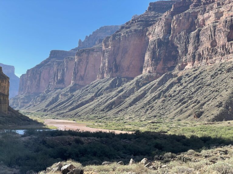
Nankoweap beach is the second-most Eastern beach in the park, a popular stopover for rafting parties. One such party was taking off as I arrived after a very wet and cold descent along Nankoweap trail. This trail is said to be one of the most difficult of the maintained trails in the park. I did not find it that hard, but I am not afraid of exposure. Those who mind exposure will find it harrowing places as you have to pass over every narrow ledges with the cliffs pressing in from the left and a giant void to your right tugging at you.
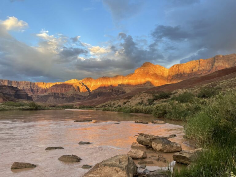
As I hiked along I experienced what I have always minded in photos of the canyon taken in full daylight. It tends to yield pictures that look a bit hazy and kind of flat. early morning or late afternoon pictures, by contrast tend to look a bit better in my opinion.
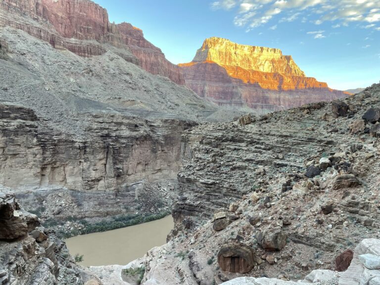
This picture was taken near one of several side canyons west of Nankoweap in the early morning. The hiking is challenging as it is almost entirely along use trails or off-trail. There are plants with thorns an inch long that apparently need a blood meal like a mosquito for their life cycle, the sun is relentless and shade is at a premium. I don’t know how people do this in 100 degree weather.
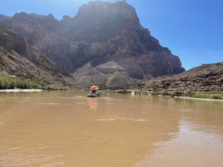
I had not quite reached the recommended ferry point as I rushed along the bank to reach said point at the time I figured I needed to be there to get a ride when I heard voices behind me and there was rafting party right there. They had not yet seen me when I asked for a ride and they readily agreed. I was plied with a cold beer and food while we drifted along and across the river. These rafting parties live lives of comparative luxury in comparison to a backpacker. The boat ahead of us had a sun umbrella to provide some shade from the unrelenting sun.
I was fortunate to be able to wade the Little Colorado as its levels had receded sufficiently after recent rains that the depth and the flow rate were manageable for me. The water level was to hip belt height for me (6’4″) and the flow made my hiking poles vibrate. That’s a level I am still comfortable with. Another hiker a day or two behind me reported that he could not cross the stream when he tried as there were more thunderstorms and heavy rains in the lands off the canyon. You can see the consequences of this additional inflow in the turbidity of the river. This, incidentally, made the preparation of drinking water from river water a really time consuming chore.
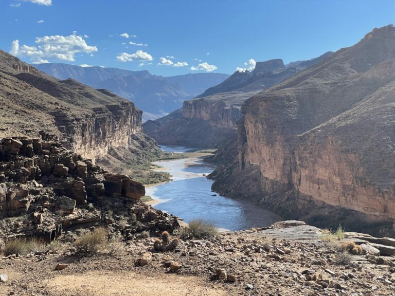
After you have crossed the Little Colorado you walk on the Beamer trail, a narrow trail or “trail” high up on the edge of the cliffs above the river. The exposure is something to behold in places. Washes cross the ledge and these are simply wild. Water from a large drainage area is shooting down these drainages during rains and you would be suicidal if you were to cross them under these conditions. When they are dry, as during my hike, they are just a wild jumble of rocks of all sizes, mud and sand. The floods remodel the washes every time they happen, so you need to have good route finding skills to get across them and to reconnect with the trail running along the cliffs above the river.
The second to last night I spent at river level on the South bank was at Cardenas beach. From there you have a choice to take the Tanner trail up to the South rim or you can continue and move up to the South rim via the Grandview trail (my choice) or via the East Tonto trail and then the South Kaibab trail (ugh!). I wanted to see more of the river, first of all, and the Tanner trail spits you out on the South rim very close to the East entry and it’s challenging to get to the resupply point on the South rim.
That evening at Cardenas was a real delight as Nature pulled off a real light show.
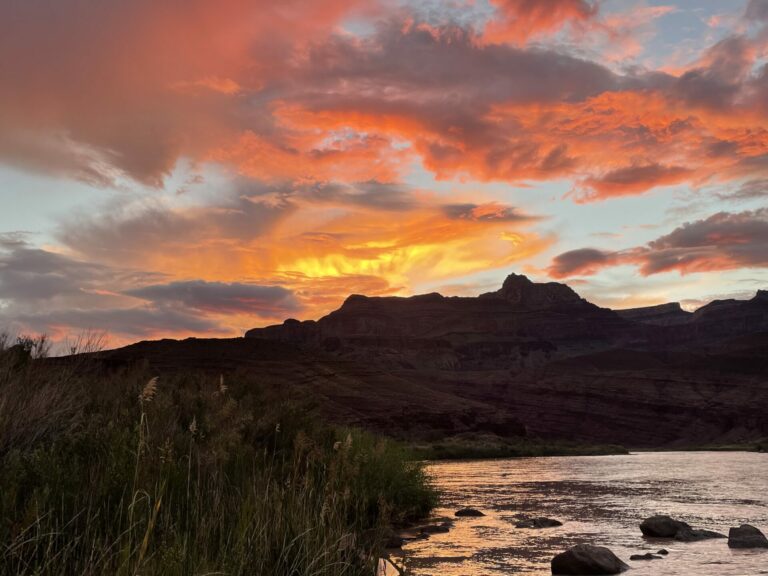
As my water filter worked drop by drop to get me some water to cook dinner with I had a lot of time to capture the light show around me. It was an exceptional evening.
From Cardenas beach you ascend along the Escalante trail which takes you up some 1500 ft only to dump you back down at the beach again. I was lucky in meeting a rafting party at the beach who were delighted to wine and dine me in exchange for stories from the trail. By that time on the trail I am delighted to eat something else than my standard dinners and to drink something with a tad more flavor than water.
This picture was taken along a ridge shortly before you start descending gain to river level.The timing was not quite ideal, I am told the view is even more impressive later in the PM, but I had to get down to river level again in order to reach water and there was a difficult canyon waiting for me to descend into and then make my way to the shore. It lived up to its reputation and I reached the beach with maybe 45 min of daylight to spare.
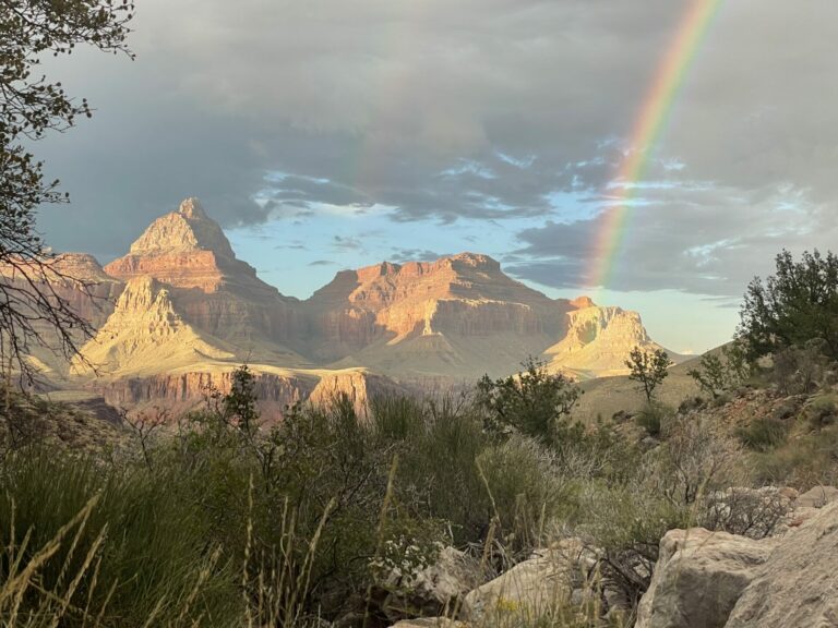
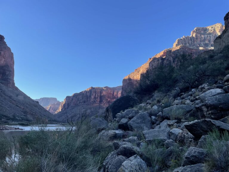
This is the view from Hance trail, which is the first portion of the ascent from river level to the South rim, over to the North shore across the river. The weather causing the rainbow was going to hit me 30 min later, leading a very uncomfortable night on a narrow ledge below Horseshoe Mesa, as I had no way to determine how the weather was going to develop during the night. You don’t want to camp in a sandy drainage when rain is even a remote possibility.
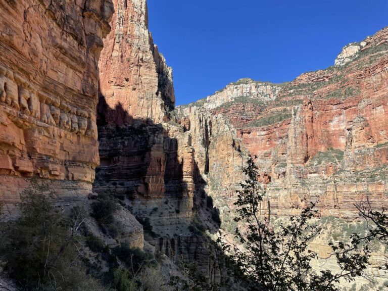
The Kaibab trail is the main corridor to get from the South to the North rim or vice versa. There are other trails, but they all require a ferry ride across the Colorado, while the Kaibab trail uses a suspension bridge near Phantom Ranch to get you across the river. The ascent from river level is gentle at first and then above the Manzanita rest house the going gets tough abruptly.
You may be able to see the trail just at the foot of the cliffs on the left. You then contour into the shady area on the left where a series of switchbacks elevates you to roughly the level where the sunny and shady areas border each other. From there you climb deeper into the valley behind the yellow rock in the center of the picture continuously rising through the red rock you see above it in the center of the picture below the white top layer.
It’s about a 5.5k ft climb and it takes you most of the day even if you start before sunrise on the South rim. Most of the time you don’t even see where you’ll be walking five minutes hence unless you can spot people who are ahead of you. I had a great time.
Baud
I am livid.
Cool shots. GC is a bucket list item for me. One day.
Princess
Amazing.
raven
Awesome!
Wag
The view from the Hance Trail is the kind of view that helps temper Type 3 fun into Type 2 fun. Maybe call it Type 2.5?
What a phenomenal trip. Nicely done
Betty
Sounds like a grueling experience. Just staying hydrated must have been challenging. Congratulations on making it through.
AM in NC
Wow. What an adventure! Do you mind if I ask how old you are?
Thanks for sharing the photos and narrative of your journey.
TKH
@AM in NC: I turned 69 a few days before entering the canyon. I am out backpacking four to five months a year, doing somewhere between 600 to a 1000 miles per year, depending on the difficulty of the route I am on.
Kevin
Great pictures and narrative. Must have been an adventure.
JPL
Your pictures are amazing!
SteveinPHX
Great story. Great photos.
Mike S (Now with a Democratic Congressperson!)
Thanks for sharing this. I know I will never see the Grand Canyon from these points myself. My fear of heights makes those trails impossible.
Although I have done and and can do whitewater rafting. Cold beverages and a sunshade, hmmm….
Thanks again!
JanieM
Stunning place, wonderful pictures. I would put several of them on my wall…..
And they’re giving me nostalgia like you wouldn’t believe. Except that having been there, you would.
I hiked in the Canyon for two weeks in 1972 and again for a shorter trip in 1984. The first trip was down the Bright Angel and then partway up the North Kaibab, where we camped for a while and did shorter walks, then went back out the way we had come.
The later trip was down the South Kaibab and then upriver from Phantom Ranch along a trail I can’t remember the name of, that ran alongside a drop that would have landed anyone in the river who took a misstep. I did fine on that trail while we were on it, then spent a lot of the night in terror, knowing I had to go back over it to get out. Our assigned camping place had us “sleeping in the arms of Zoroaster” (Zoroaster Temple loomed above).
Such memories! In 1972 the place wasn’t the zoo that it would become later. There were lots of people (including lots of idiots) on the Bright Angel even then, but there was still basically no one on the South Kaibab in 1984, although unlike in ’72 there was a reservation system for camping spots in place.
Thanks for both the pictures and the memories they trigger. I’m 72 and my knees and other joints couldn’t possibly get me to the river these days. You’re lucky to be going strong, and your hiking adventures sound wonderful.
MelissaM
Lovely! that rainbow picture is just wonderful! I’d love to hike with you but I know right now I’m not in any shape to. Maybe when I’m 69 in 14 years?
Yutsano
It’s too bad the weather kept you from going further. I think I see a glint of gold under that rainbow.
Such stunning photos! I still stand eternally grateful that Teddy Roosevelt created the National Park system. I shudder to think what the canyon would look like if he hadn’t.
Netto
@TKH: What a terrific trip!
Are you on speaking terms with Colin Fletcher? ;-) I read his books way back when with the idle “if only” attitude that keeps most of us in our easy chairs.
munira
The rainbow, the sunset, the light on the canyon walls – beautiful.
way2blue
If you thought the Kaibab trail was challenging, I wonder how mere mortals fare? [N.B., A group at work floated the Colorado River through the Grand Canyon a few times with sidescan sonar to see whether the effort to release flood-sized pulses of water from behind the Glen Canyon Dam succeeded in moving sand from the river bed back onto the beaches.]
Thanks for sharing these remarkable vistas of the Grand Canyon…
TheOtherHank
I rowed a raft down the canyon in the summer of ’83. It was amazing. On of my favorite memories is the night we were camped on a beach in the wider part of the canyon and when the full moon came up over the rim it woke me up. The view of the bottom of the GC illuminated by the light of the full moon is really something.
JustRuss
Amazing. The Hance Trail photo is sublime.
Chris T.
@Mike S (Now with a Democratic Congressperson!):
Me too, although a tiny dose of escitalopram (generic Lexapro) helped out a huge amount here.
—
Re the haze in mid-day pictures: a polarized filter would help a lot, not sure if one can do that with an iPhone camera though. (Probably someone makes some sort of clip-on device?)
What really amazes me are the people who do the rim-to-rim run. 😅
Steve from Mendocino
Lovely pictures. Nice framing. Good use of light and shadow. A pleasure to look at your work.
Another Scott
Fantastic pictures and stories.
The first time I saw the GC was when I accompanied my J to a conference in Phoenix in September(?). After her meeting were done, we saw the weather forecast – 65F and sunny – when we started the drive up. We pulled into our parking space at the South Rim just in time for a heavy bank of clouds to fill the canyon. I saw a tiny glimpse of it, J didn’t see anything. :-/
The next morning we got up and the rangers said we may want to leave soon because they were expecting the roads to be impassible with snow in the next few hours. We left and spent a few days in Sedona instead.
We managed to get back a few years later and had a nice time hiking around the south rim. We met some old ranger guy who was (like us, flatlanders) formerly from NoVA who said that he used to have knee problems but that went away when he started doing trail running marathons – had done 50 or so of them by that time. He was telling stories about young tourists in flip-flops hiking down to the river (without water) and having severe issues trying to get back out again. We weren’t crazy enough to go that far.
Humans are weird!!
Thanks again.
Cheers,
Scott.
Wil
Don’t hold it against those who drive along the top rim for two hours and see what can be seen from there.
I’ll be doing exactly that in a few months with older people in tow that are not able to do any sort of hiking.
JanieM
@Another Scott:
When I hiked there in 1984 it was November — snowing at the rim and a nice July day in New England down by the river. A mile of elevation change will do that to you.
TKH
Thank you all, you are being very kind. I am pleased that looking at these pictures was a walk down memory lane for some of you, and in a good way!
Dan B
There’s a lot of spectacular and sublime scenery in Washington and I’ve backpacked much of it, including many hikes where the topography was more than a vertical mile, but the Grand Canyon (North Rim) blew me away. These pictures are an amazingly different perspective. The other park that was equally amazing to me was Glacier. There’s something about nearly vertical walls.
Traveller
I was particularly impressed by your lack of coyness, no shilly-shally.ing about your age…but then of course I suppose there should not have been any of that…living a life of a lifetime several times over is something to wear as a badge of…(honor? Courage?)…but regardless it is impressive and maybe a goal for others sometimes to live up to where you are, maybe, or at least to vicariously enjoy.
I am always impressed by your photo journals from the far edges of the world. Thanks!
TKH
@Traveller: Thanks! The birthdays come around, whether you acknowledge them or not. I am always mystified when I encounter the shroud of secrecy around that topic.
To me the experience of long distance hiking was truly liberating when I started at 62. I was worried that they’d be carrying me out of my office and lab, feet first on a stretcher. I was a chemistry prof and had become weary of the grind. And there, I would not say unexpectedly, but delightfully I stumbled onto something that I could use my energy for, for however long my luck will be holding out.
And I am happy to encourage others to go out, take a chance or a risk, and find out that you may be capable of more than you know or give yourself credit for. Without being preachy about it. I don’t want to become the Marie Kondo of hiking after all.
Tehanu
I’m one of those 2 hours at the rim folks — it looked so much like all the postcards that it just made no impression. Your photos, OTOH, are fantastic! I had no idea of how it looks when you’re down in it. Really wonderful!
TKH
@Wil: I am not holding it against them. Just as you will be doing, I did with my parents when they were in their seventies.
@Tehanu: This is what I am talking about! If you can do it physically, go down at least to the Tonto trail level and the experience will be entirely different and so much more worthwhile.